Prioritize…
After completing this section, you will be able to:
- define general circulation and demonstrate understanding of a “cell” in the atmospheric circulation
- define a thermally-direct cell and how air rises, sinks, and moves either north or south based on where the atmosphere is warmer or cooler.
Read…
OK, let's start actually using those forces we just learned about to explain the general circulation of the climate system. The “general circulation” in a climate context refers to the large-scale movement of air that helps distribute heat and moisture across the Earth.
As previously discussed, equatorial regions receive intense solar radiation, more so than regions further north and south away from the equator. Without a mechanism to redistribute this heat, the equatorial regions would get hotter, and the higher latitudes colder than they currently are. The intense solar radiation in equatorial regions leads to a warm surface with warm moist air in the atmospheric column above it.
The extra warming at low latitudes fosters something known as convective instability, i.e., the unstable situation of having relatively light air underlying relatively heavy air. Where that instability exists, there is rising motion in the atmosphere as the relatively light (warm and moist) air rises above the heavier (colder and drier)air.
Take a look at this YouTube video detailing an experiment you can do at home on your stove top that illustrates the concept. Now imagine the stove top as the equator – instead of the burner heating up, it’s the Earth’s surface due to the copious amounts of solar radiation!
Video: Warm Air Rises - The Spinning Paper Plate (2:37)
Warm Air Rises — The Spinning Paper Plate
Presenter: Hello, I am Jared, back with some more experiments on the idea that warm air rises, heat rises. It is difficult to see that. Kids have that schema, that background knowledge that warm air rises. They have seen hot air balloons, they have gone through that fire company training, you know, of smoke detectors up high because smoke rises. The smoke rises because the warm air is heated and it rises.
And just to get them to see that is really an interesting thing, and it is easy to do. So I have a paper plate, a Sharpie, and all I am going to do is draw a swirl pattern on that plate. Nothing pretty, I am going to start in the center, and I am going to show you what that looks like, taking my time. There is no exact pattern here, I am just going into a swirl... does not take long... to the edge... and I have a swirl. When I cut that out, I am going to be left with this. And when I hold it up, it is going to dangle down. I did snip the outer edge of the plate off because it would dangle, oh, a good two or three feet. So I snipped it off, and what I want to be able to do is hold this without getting my hand burned.
So I am going to take a simple straight pin drive it through, so the head of the pin is going to keep it from falling through, and I have this. Nothing is happening. This is surrounded by air, but it is not spinning. So what I need is, I need to heat some air to get it to rise. It is going to hit the bottom part of this wind spiral and actually start it turning. So I have a burner. I am going to turn the burner on, it is going to heat up. And the kids have seen this, they have looked down the blacktop road, and they could see the heat waves rising off of the road. So it is simple, this is just the way so they do not have to sit there and squint and try and see the rising heat waves.
They are going to be able to see the heat waves rising because the wind spiral is going to start spinning. So I am going to slowly make sure this is heating up. It is not super hot yet, so I am going to make sure, I am going to slide it over, and it is starting to spin! Again, not my Jedi mind powers making this thing spin. The air is heated, it is rising up, it is hitting the bottom of the wind spiral, and it is actually pushing it and rotating it. It stops- and there it is spinning- and it stops. Warm air rises. Thanks for watching!
This rising motion at the equator leads to what scientists call a cell. An atmospheric cell is a large-scale circulation pattern in the Earth's atmosphere, driven by temperature and pressure differences across latitudes. These cells involve the upward movement of warm and moist air, the downward movement of cooler and drier air, and the associated transport of air either northward or southward at different levels of the atmosphere.
The particular cell we’re discussing is called the Hadley circulation, named after George Hadley (1685-1768), a lawyer who, while not a climate scientist, developed an interest in weather patterns as a hobby.
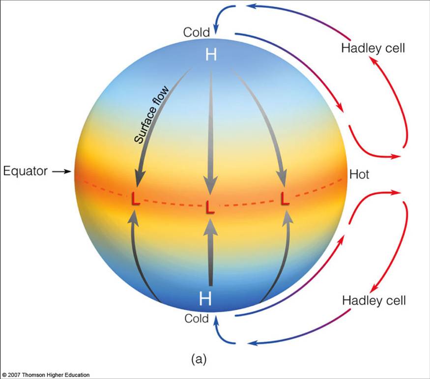
The Hadley circulation can be thought of as a giant conveyor belt in the sky, responsible for redistributing heat and moisture across the planet. Near the equator, air at the surface warms and moistens as intense solar radiation is absorbed by surface ocean waters and land at these latitudes. This warm, moist, energetic air rises and ascends to a region known as the tropopause, about 17 kilometers above the surface at the equator. As the air rises, it cools and loses moisture to precipitation. At this altitude, the air begins to move poleward rather than continuing into the stratosphere. Eventually, the air sinks back toward the surface at higher latitudes.
As warm air rises near the equator and sinks at higher latitudes, it creates a pressure gradient near the surface, with lower pressure near the equator and higher pressure in the subtropics. In the figure below, “H” indicates areas of high pressure and “L” represents low-pressure regions. As we discussed earlier, air flows from regions of higher pressure to lower pressure. This pressure difference drives equatorward flow in the lower parts of the atmosphere (depicted by the gray lines labeled “surface flow”). The rest of the circulation, with its rising and sinking motion, is shown by the red and blue arrows.
In simple terms, at the surface, air flows from cooler, high-pressure regions toward warmer, low-pressure regions. To balance the surface flow, higher up in the atmosphere, the air flows from regions above warm surfaces to regions above cooler surfaces.
Here’s a simpler schematic that may clarify things. Notice that cells where warm air rises and cool air sinks are called thermally-direct cells, and the Hadley circulation is a prime example of this. This may seem intuitive, but since I’m pointing it out, you can probably guess that we’ll soon be discussing thermally indirect cells, where air is actually sinking in the warmer region!

I want to emphasize that this Hadley cell is always on – there is always more energy striking the Earth’s surface at the equator than the polar regions. It is like the “open 24 hours a day, 7 days a week, 365 days a year” player in the climate system. This is important for understanding the climate of tropical regions. The ascending part of the Hadley cell leads to rainy equatorial regions. The descending part of the Hadley cell, where air sinks back down to the surface, leads to clear skies and less rainfall in subtropical regions. Meanwhile, the lower branch of the Hadley cell circulation carries excess moisture from these subtropical areas back toward the equator. But more on this in a little while!