Prioritize...
After finishing this section, you should be able to:
- Explain, at the global scale, what we have seen in terms of changes in precipitation and drought.
- Give some examples of why precipitation patterns vary regionally, including those in a changing climate.
Read...
Remember when we discussed how the general circulation of the atmosphere—the global pattern of winds and weather—is shaped by the uneven heating of Earth? Because the equator receives more solar energy than the poles, this imbalance drives a vast system of atmospheric circulations that distribute heat and moisture around the planet. So, when we talk about climate change, we’re not only talking about shifts in temperature; we’re also talking about changes in this energy imbalance that can impact circulation patterns. It’s logical, then, to expect climate change to influence large-scale precipitation trends as well.
We just explored how a warmer atmosphere holds more moisture, which translates into heavier downpours when that moisture eventually condenses. In the U.S., the data confirm this trend toward more intense rainfall events. However, precipitation patterns are far from simple. It’s one thing to say heavier downpours are on the rise, but predicting how total precipitation will change in any given place—how much rain or snow falls over an entire season or year—is much more complex. Precipitation changes are “noisier,” meaning they vary a lot by location and can be harder to interpret consistently over time.
Why is precipitation so variable? The reasons range from local topography to larger-scale climate patterns. For instance, mountain ranges can trap moisture on their windward sides, creating wetter conditions there, while casting a “rain shadow” of drier conditions on their leeward sides. Oceans also play a big role: they support massive air and water currents, like the monsoons, which bring seasonal rain to regions like South Asia and East Africa. Ocean-atmosphere interactions are critical, and when they shift even slightly, they can change rainfall patterns for entire regions.
Unlike temperature, which has shown a more uniform warming trend globally, precipitation trends are a mixed bag—some regions are seeing more rain, while others face more frequent droughts. These changes don’t follow the same clear patterns as temperature, which is why scientists continue to investigate how climate change impacts precipitation in different parts of the world. This research is crucial for understanding the full picture of change impacts.
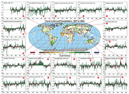
Now, let’s zoom out and take a more global look at total precipitation patterns. The figure below maps how different areas have seen precipitation either increase (in green) or decrease (in brown) over the 20th century. The small red dots mark different locations, each with its own time series showing how precipitation has trended over the years.
Pretty messy, right? Some areas show clear trends, but they’re all over the map. Take southern South America, for example—the time series in the bottom left corner shows a noticeable increase in rainfall across the century, indicating that this region is becoming wetter. On the other hand, regions like southern Asia and India (fourth row, third column) show a drying trend, especially over the past 30 years. These diverse precipitation signals across the world are essential to understand because climate change isn’t affecting every region equally. As global conditions shift, the “winners and losers” in terms of rainfall and drought may shift too. Places that historically supported lush forests and agriculture may face more frequent droughts, while regions previously considered too dry for intensive farming might start seeing conditions that favor crops. By the end of this course, we’ll dive into what these shifts could mean for geopolitics and resource distribution.
While these precipitation patterns are complex and heavily influenced by local factors, we do start to see some overarching trends. Remember the Clausius-Clapeyron relationship? It’s that principle telling us that a warmer atmosphere holds more water vapor before it condenses into cloud droplets and, eventually, rain. This relationship suggests that with a warming climate, regions near the equator—where the Hadley cell drives constant upward motion—might get wetter over time. Why? A warmer, moisture-laden lower atmosphere in equatorial regions means more available water vapor for rain.
So, does this theory hold up in real-world data? When we look at precipitation trends by latitude, we start to see supporting evidence. By averaging observed precipitation changes across latitude bands, a pattern emerges: certain regions, especially near the equator, are indeed becoming wetter over time.
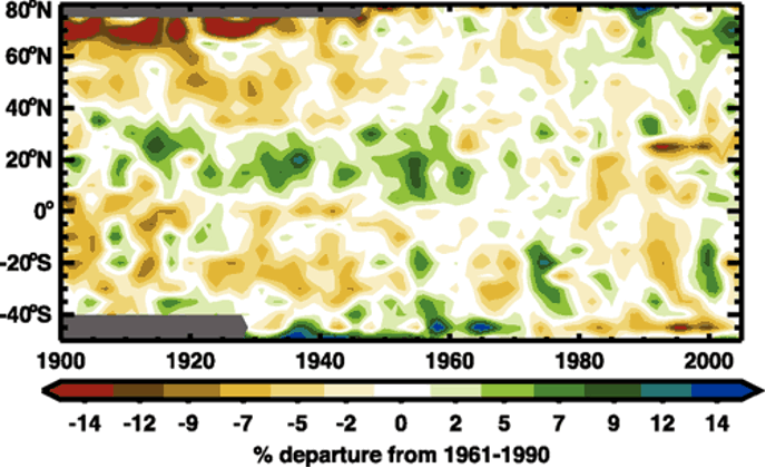
Take a look at the broad green band around 15°N latitude on the graph. This region aligns closely with the Intertropical Convergence Zone (ITCZ), where equatorial rain belts form due to warm, rising air. Seeing a green band here suggests that rainfall in the ITCZ has increased, which matches what we’d expect as the atmosphere warms and holds more moisture. Meanwhile, higher latitudes show a trend toward drying, represented by yellows and browns near the top and bottom of the graph. These drying patterns are consistent with some climate model predictions (we’ll dig into those next), but precipitation trends are notoriously variable. From year to year and even decade to decade, regional precipitation can swing widely, making it hard to confirm clear, theory-matching patterns like we saw with temperature, sea ice, or sea level.
An essential factor in this story is drought—periods of unusually low rainfall. But drought isn’t just about less rain; it also depends on temperature. Imagine this: when rainfall drops, the ground heats up faster, which speeds up evaporation and further dries out soil. This reduction in soil moisture limits the water available for plants, creating harsher conditions for growth. This process can even reinforce itself, with drier soil warming up faster, leading to even more moisture loss—a process often described as “drought begets drought.”
Drought patterns, like precipitation, are complex and vary by region. Yet, we’re seeing droughts become more common in some areas, even in regions where rainfall hasn’t decreased significantly. Warmer temperatures alone can drive moisture out of the soil, which is especially clear when we look at tools like the Palmer Drought Severity Index (PDSI). The PDSI is a numeric index for soil moisture that factors in both temperature and precipitation. The more negative the PDSI number, the stronger the drought.
Check out the time series of the PDSI over the U.S. from 1890 to 2020 below. Do any patterns stand out? Notice the deep drop in the 1930s—this was the infamous Dust Bowl, when a severe drought brought destructive dust storms, devastating agriculture across the American and Canadian prairies. There’s another notable drought in the 1950s, but since then, we haven’t seen anything as extreme. What’s important to note here is that droughts haven’t disappeared despite increases in intense rainfall events. Just because we expect heavier downpours as the atmosphere warms doesn’t mean droughts are off the table in U.S. climate trends. While researchers are still examining historical data, I’d argue it’s too early to definitively say climate change is tilting the scales toward more or fewer droughts in the long run—at least not yet.
