Prioritize...
By the end of this section, you should be able to:
- discuss how the sun’s energy is spread out over the spherical surface of the Earth,
- explain how the Earth's tilt on its axis of rotation impacts how directly this energy strikes the Earth throughout the year, and
- detail how seasons result from the changing angle at which the sun strikes the earth.
Read...
We now have a conceptual understanding of different types of radiation and what happens to radiation moving throughout a medium. But how does this pertain to the climate system?
OK, let’s start with where the energy actually comes from. By far, the most significant source of energy input into the Earth system is via solar radiation – i.e., the sun! It’s not the only energy source – others include geothermal energy, tidal energy, and energy from cosmic rays – but these are all much, much, smaller than the energy we get from our nearest star.
Recall that from above, the spherical sun emits a tremendous amount of energy into space. This energy is emitted isotropically (equally in all directions). As it travels out into space, it spreads out and the energy per unit area of space it passes through becomes less. Imagine blowing up a latex balloon – when you begin to inflate the balloon, the latex is still relatively “dense” and hard to see through. But as you keep blowing it up and spreading that material over larger and larger radii, the density becomes smaller, and the balloon thins. That “thinning” also happens with radiation density. It’s one of the reasons we are quite thankful we are not living on Mercury, where the energy density from the sun is much higher. The same goes for Pluto, too, which is very cold thanks to this process.
On Earth, at the top of the atmosphere (sometimes abbreviated TOA, you can think of this as the area in space just above all molecules in the Earth’s atmosphere), the solar flux density is – a value known as the solar constant. What does this tell us? Well, for our orbital radius, we get 1360 watts of energy input for every square meter (a two-dimensional square 1m on both sides) of that energy’s intersection with the Earth. A watt is just an energy flow per unit time – it is the same as Joules per second. So it’s kind of like measuring how much water is going through a hose and being sprayed on your lawn (well, if instead of gallons we talked about Joules!). We call this a constant because the sun is putting out almost the same amount of energy day-after-day, year-after-year. This varies a bit with sunspots every so often, but can be effectively thought of as something that will remain the same for our entire lifetime (more on its changes through the Earth’s history later!).
Because the Earth is a sphere, the actual average energy per unit area the Earth receives is a factor of four less. Why four you say? Well, imagine holding up a basketball and allowing your friend to shine a flashlight on it. For the person standing with the flashlight, the ball looks like a circle to them – the rays of light emanating from the flashlight get intercepted by the cross-sectional area of the ball. However, you (the one actually holding the ball) can see that the energy is actually not being spread across the “circle” that your friend sees, but rather the surface of the ball (for now, just the half facing the light, but if you spin the ball like the Earth rotates, eventually light is spread over the whole ball for each full rotation). Since the area of a circle is , but the surface area of a sphere is , the actual energy input the Earth receives per unit area is or . This is sometimes referred to as the solar “insolation” – think about it as Incoming SOLar radiATION.
To give you a visual, see the figure below. The yellow disk is what the sun sees Earth as -- a big circle. But we know that the Earth is a sphere, so the energy contained within this circle must be spread out over the surface area of the sphere. We just do our simple division above and get a factor of 4!

Latitudinal variations in solar insolation
We should note that this energy isn’t evenly spread over the surface, even with the planet rotating. The Earth is spherical (well, mostly spherical, although we’ll assume this is the case in this class) which means that as it orbits the sun, different latitudes (from the equator to the poles) receive sunlight at different angles. Why is this? Well, remember our basketball analogy from before – from the perspective of the sun, we see the Earth as just a circle that gets in the way of the rays we send out. Since the sun is quite far from the Earth, scientists make an assumption -- we assume the light is plane-parallel. We assume that every ray of light striking the Earth is moving parallel to all the other rays of light. This means that in areas where these solar rays are moving perpendicular to the Earth’s surface (toward the middle of our basketball or the Equator of the Earth), they are more concentrated in space. You can think of this as “more rays per square meter.” At high latitudes (towards the top and bottom of the basketball or our North and South Poles on Earth), these rays strike at an angle, which spreads them out across the surface (or disperses them). This means “fewer rays per square meter.” You can test this yourself at home right now if you want. Direct your attention to these side-by-side photos of a flashlight shining on a wall.
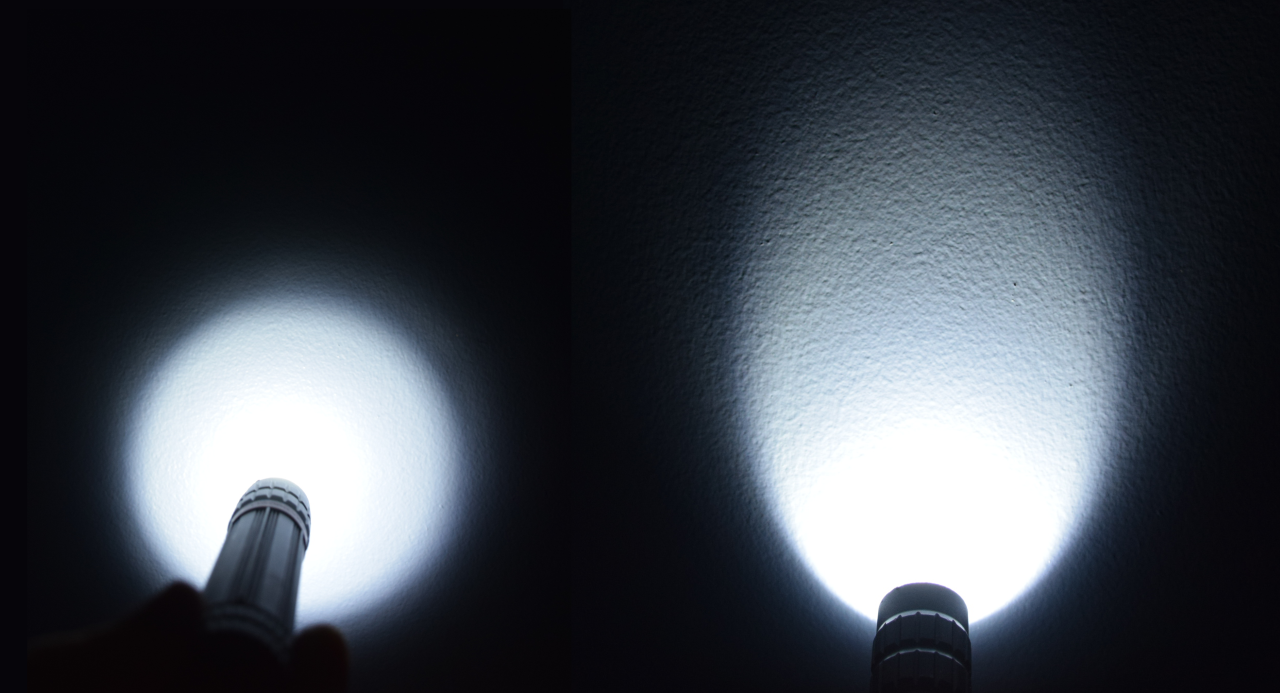
Please note that when the light from the flashlight strikes the surface at a rather direct angle, the light focuses on a rather small area. In other words, the light is intense. On the other hand, if the flashlight is tilted so that the light strikes the surface at a lower angle, the light spreads over a larger area, making the light less intense. Go find a dark room and a flashlight and try it out for yourself!
See the figure below for a visual interpretation.

What this means is over the course of a year, the Equator receives more radiation than higher latitudes. See the figure below, which shows the top of the atmosphere insolation. The average over this whole map is approximately (which we discussed above!), but there are higher values near the Equator where the sun’s radiation is most perpendicular and lower values towards the North and South Poles where the radiation strikes the planet at more oblique angles. Keep this geometry in mind – the fact that the Equator receives more energy from the sun than polar regions underpins why our atmosphere and ocean circulations behave the way they do.

Seasonal variations in solar insolation
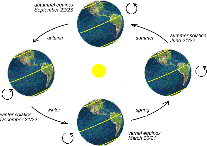
What I showed you above is an annual average of radiation. Can you surmise why I did that? I deliberately left out one last important component of solar geometry –the tilt of the Earth's axis and Earth's orbit around the sun give rise to the seasons. If we didn’t have tilt, everything we talked about above would hold, but it’d be very close to the same temperature every day all year at a given spot on the planet. However, we know from personal experience in the United States that we aren’t receiving the same amount of energy all year long – we generally wear sunscreen more often in summer and usually must bundle up in winter. Why?
At the heart of Earth's seasonal variations is the tilt of its axis. The Earth’s axis can be shown by a line running from the North Pole to the South Pole, and the planet rotates around this axis like a toy top. But if an extraterrestrial alien were to stumble upon our planet in space, they’d realize that the poles are not perfectly up and down (or perpendicular) to its orbital plane, but rather the Earth is slightly tilted. In fact, it is inclined at an angle of approximately 23.5 degrees relative to its orbital plane. As Earth orbits the sun in an elliptical path, the orientation of its axis remains remarkably consistent – it’s always tilted at 23.5 degrees towards the North Star, no matter where it is in its orbit. This means that during different times of the year, specific parts of the Earth lean either toward or away from the sun.
When one hemisphere is tilted toward the sun, it receives sunlight that is more perpendicular to the surface, just like we discussed above. Like a nearly downward pointing flashlight shining directly on the surface from our dark room experiment, concentrated sunlight has heating power consistent with the elevated temperatures of summer. In the summer hemisphere, we also see that this is manifested in longer daylight hours and the sun can climb higher in the sky. You may not have considered this, but try to imagine where you see the sun in the sky during winter – it always feels like it’s not getting too far away from the horizon, even in the middle of the day! But you can certainly remember hot summer days when you craned your neck, stared straight up, and the sun was staring right back at you from directly overhead. This is the recipe for summer's warmth and extended days. In contrast, sunlight arrives at a more oblique angle when that hemisphere tilts away from the sun, leading to shorter days and colder temperatures. This means there are two days per year when the Earth is tilted either as far away or as close to the sun as possible. You may not know it, but you have heard of these days – they are the “solstices.” The periods when Earth's axis is neither tilted toward nor away from the sun are the transitional seasons of spring and autumn, when day and night lengths are relatively equal. There are two days every year when the Earth isn’t tilted away or towards the sun – these are the “equinoxes.”
Think About It...
Do these maps make sense? Think about what the weather is like in December. Do you think your hometown gets more or less direct solar radiation during that month?
For now, we will focus on the annual averages to smooth out these seasonal variations. Still, we’ll return to the concepts of summer and winter and their importance for describing the temporal variations in climate later.
Fate of solar radiation striking the Earth
Since the sun is a constant emitter, the Earth is always receiving of energy at the top of the atmosphere. But why are we being so specific, saying the “top of the atmosphere” – that seems awfully suspicious. All that energy isn’t immediately transmitted straight to the surface – it can also be scattered or absorbed. So where does this energy go?
- About 30% is reflected back to space by air molecules, clouds, and the earth's surface. Note that I'm using the word “reflection” as a loose substitute for “back-scattering,” but there's a big difference between this loose use of “reflection” and the classic, pure interpretation of “reflection.” Pure reflection means that the angle at which radiation strikes an object must equal the angle at which the radiation is redirected from the object (think about how a billiard ball bounces off a bumper on a pool table).
- About 20% gets absorbed by clouds and atmospheric gases.
- Roughly 50% is transmitted and ultimately absorbed by the Earth's surface.

So, of the solar radiation reaching Earth's atmosphere, about 30% of it ends up back in space. It turns out we have a special name for the reflected portion -- albedo, which simply means striking some object that is ultimately not absorbed by it.
Albedo can vary between 0.0 and 1.0. An albedo close to 1.0 means almost 100% of the incoming solar energy is reflected away from the Earth system -- with respect to visible radiation, a mirror has an albedo close to 1.0. In contrast, an albedo close to 0.0 means almost all of it is being absorbed by the surface the radiation strikes. Think something matte black, like fresh asphalt.
On average, the Earth’s albedo is about 30 percent (0.3), but albedo over parts of the Earth varies greatly from location to location and time to time. Things that we consider “white” have high albedos. Two important surfaces that have high albedos are clouds and snow. Do you remember that sometimes your eyes hurt when walking outside on a sunny day after a fresh snowfall? Since snow has a high albedo, solar radiation is being reflected back towards your eyes, effectively giving you a “double whammy” of brightness – the sunlight coming down and the reflected radiation back up. Not a bad idea to keep those sunglasses handy in your glove box! On the other hand, surfaces like asphalt parking lots, forests, or ocean water tend to have low albedos because they don't reflect much of the solar radiation that strikes them. This is why it’s not pleasant to walk on asphalt on a sunny summer day.

Check out the map below, which shows the January surface albedo over the globe. For this figure, clouds have been removed – more on that in a second -- we are only considering the probability of sunlight being reflected at the surface on a sunny day. At high latitudes in the winter hemisphere (northern North America and Eurasia) albedo values are high, owing to snow and ice on the ground. The same holds for mountainous areas like parts of the Rocky Mountains, the Alps, and the Himalayas.

But wait a minute, why does Northern Africa have a similar albedo to the snowy high latitudes? Can you think of a major geographic feature in that area? Northern Africa is broadly covered by the Saharan Desert, which is generally devoid of large areas of water or vegetation. But sand is (perhaps somewhat surprisingly to you) a highly reflective surface for shortwave radiation from the sun. Next time you are at a large, sandy, beach, try and see whether you need your sunglasses more when compared to if you were walking in a grassy field or a forest nearby. You’ll find that your eyes behave very similarly to being over a snowy surface, and you’ll be squinting more when sitting in your lounge chair with your toes in the sand!
Now you may say, “Wait, if the sand in the Sahara reflects so much radiation, why is it so hot there?” That’s an excellent question, and we’ll answer that question in a few lectures – it’s the atmospheric circulation that plays a key role.
