Climate Change and Extreme Weather
Climate Change and Extreme WeatherPrioritize...
When you've completed this section, you should be able to:
- Explain the difference between climate change’s influence on the likelihood of extreme weather events and the misconception that climate change directly causes specific events.
- Describe how global warming shifts the probability of extreme heat and cold events, using the analogy of a “loaded die” to illustrate changes in the frequency of extreme temperatures.
- Explain why we see more record highs than record lows in a warming climate.
Read...
The way most people feel the effects of climate change isn’t through gradual shifts in average temperatures but rather in the increased frequency and intensity of extreme, often severe weather events. These are broadly termed “extreme weather.” Extreme weather can mean (but this isn't an exhaustive list by any means!) things like hurricanes, intense heatwaves, prolonged droughts, heavy rainfall and flooding, severe wildfires, and extreme winter storms.
The link between climate change and extreme weather grabs a lot of attention—and for good reason. As we've learned over the past few lessons, climate change is complex and multi-layered, with influences ranging from human activities at local scales to natural and human-induced changes on a global level. Most news stories focusing on climate change and extreme weather are actually zooming in on one key aspect: human-driven global warming. The central question is often, “How does a warming Earth impact the weather we experience on a day-to-day basis?”
However, this question often gets rephrased in a misleading way—“Did climate change *cause* this heatwave, flood, drought, or storm?” Framed this way, the answer is “no.” Climate change doesn’t directly cause specific weather events. That is, we can't unequivocally say Hurricane Katrina only happened because of climate change, and otherwise, it would be a perfectly pleasant sunny day! Blistering heatwaves, severe thunderstorms, devastating floods, and powerful hurricanes all existed long before human influence on the climate. So, while climate change doesn’t directly trigger a specific heatwave or flood, scientists' critical questions are whether and how climate change makes these extreme events more intense, frequent, impactful, or likely to happen in certain regions.
This is a complex area of study, and the science connecting climate change with extreme weather is rapidly evolving -- this lesson may not even be the same year-to-year! What is clear, though, is that the impacts of climate change on extreme weather differ from place to place. Although the globe is warming, some areas are heating up faster than others; similarly, while sea levels are rising, local factors cause them to rise unevenly across different coastlines. In short, a mix of local, regional, and global climate influences—both human-induced and natural—play into changing patterns of extreme weather. Yet, the human-driven warming of the oceans and atmosphere has certainly altered some aspects of atmospheric behavior.
Let's start with a couple of the more straightforward connections between global warming and extreme weather events. For starters, as the world has warmed, average air temperatures in many areas have increased. Not surprisingly, so have outbreaks of hot weather. On a similar note, episodes of extremely cold weather have declined, which seems intuitive.
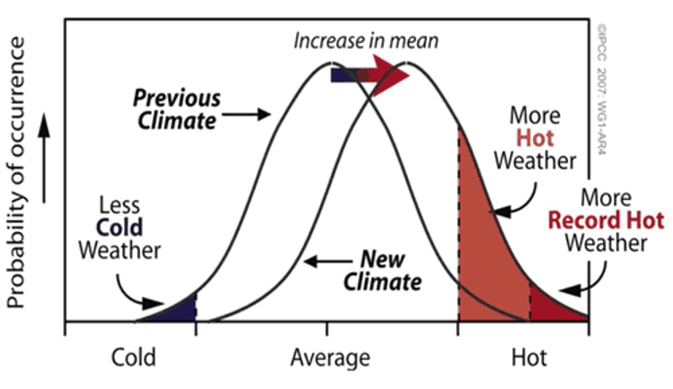
Take a look at the graph above. It shows the probability of experiencing “cold,” “near-average,” and “hot” weather. Notice that the “previous climate” curve has a “bell” shape—this is because, in a stable climate, it’s most common for temperatures to be seasonable or close to average. However, as anyone who’s been around for a few years knows, we also get stretches of both very cold (left side of the curve) and very warm (right side of the curve) weather.
Now, look at the “new climate” curve, which shows what happens when the entire temperature distribution shifts warmer. Every temperature is nudged a bit to the right, making warmer temperatures more likely. Remember our discussion of statistical distributions? What we’re seeing here is an example of how shifting a distribution affects the likelihood of different outcomes. This shift means that, while seasonable weather is still most common, “average” itself has become a little warmer. For example, if May’s average high temperature used to be around 65°F, it might now be closer to 68°F.
So, what’s the result of this shift? With the whole distribution skewed a bit warmer, extreme cold events (on the left) become less common, and extreme heat events (on the right) become more common. It makes sense—by shifting the baseline, we’re tilting the odds toward hotter days.
This doesn’t mean cold spells will vanish altogether as the world warms. Cold snaps can still happen! Take February 2015, for instance, when the eastern United States had one of its coldest months on record (going back to 1895). So, yes, even in a warming climate, frigid weather can occasionally dominate. But when we look over a long period, we start to see a trend: fewer cold spells and more frequent heatwaves.
Do we actually see more extreme heat days compared to extreme cold days? Let’s explore that by looking at decade-by-decade data on the frequency of record-breaking warm and cold days, totaling up all U.S. locations and days of the year. This is what the trend looks like through 2015.

This graph illustrates the ratio of daily record high temperatures to record low temperatures over the decades. Each bar's color and height provide insights into temperature trends:
- Red Bars: More record highs than lows.
- Green Bars: More record lows than highs.
- Bar Height: Indicates the extent of the difference. Taller bars signify a greater disparity between record highs and lows.
In a stable climate, we’d expect the number of record highs and record lows to be pretty even. And that was indeed the case through the mid-20th century: if you look at the red bars in the graph, they’re relatively short, indicating a near 1:1 ratio. In other words, it was about a coin flip whether record highs or lows were more common.
But then came the 1960s and 1970s, when mean temperatures in the Northern Hemisphere actually cooled slightly. This cooling led to more record lows than highs, as you can see with the green bars that pop up. Since then, however, there’s been a sharp shift. As the global temperature trend turned upward, particularly in the Northern Hemisphere and North America, record highs began to outnumber record lows significantly. In the past decade, the ratio of record highs to lows has soared to over 2:1, meaning extreme heat days now occur twice as often as extreme cold days. This trend aligns with the shift in the probability of heat extremes we discussed earlier.
A helpful analogy here is to think about rolling a six-sided die. Yes, yes, we’ve played with this example earlier in the semester, but let’s roll with it again (pun intended)! Let’s set up another little experiment with die rolling to see how probabilities change.
Explore Further...
Start rolling the pair of dice. One of the dice is a fair die, and the other is "loaded", though just how, you'll need to figure out. It should become clearer and clearer as time goes on, and the number of rolls increases. Note that you can "roll" in rapid succession to get larger and larger samples (you don't need to wait for the animation to complete on each roll). Start out with 1 roll, then 5, then 10, 30, 50, 100, and so on, as many as 500 or more (if you have the patience!) rolls of the die. Pay attention to the number of numbers you've rolled for each of the two dice (the percentage of times each possible value of the die is rolled is conveniently recorded for you).
Making sense of it!
Do your rolls seem to be converging towards some well-defined fraction? Is one number showing up more often on one of the two die? When you think you're ready to guess which of the two dice is loaded, go for it. You can repeat the experiment over and over (and over!) again. Sometimes it's the red die that will be loaded, other times it will be the blue die. Can you figure out which number is favored and how skewed (loaded) the results are?
(insert Jeopardy music while you experiment with the dice!)
So, as you've figured out by now, I loaded the die so that sixes would come up twice as often as they ought to. The more rolls you take, the more obvious it becomes that the die is rigged. I'm never going to be allowed to visit Vegas again!
Now, let’s think back to that first time you rolled a six with the loaded die. Was that specific roll directly due to the loading? Not exactly. Like any long-term Monopoly player would tell you, even with a fair die, you’d expect a six about one in every six rolls. But because the die is loaded, it’s now twice as likely that any given roll, including that one, would come up six. This effect becomes clearer with more rolls.
This analogy is useful for understanding how global warming affects extreme weather, like heat waves. We showed earlier that a modest warming—similar to the average global temperature increase over the past century—almost doubles the chance of seeing temperatures exceed 100°F in mid-summer. And we've also observed that the frequency of extremely hot days in the U.S. has approximately doubled since the mid-20th century.
Using this analogy, we can think of global warming as a way of “loading the weather die” toward more heat extremes. Just as we wouldn’t say that any single scorching summer day was directly caused by global warming, we can say that the odds of such a day occurring have doubled. In other words, the "weather die" is increasingly weighted toward extreme heat events across the U.S. and around the globe.