Lesson 5: The General Circulations in the Climate System
Lesson 5: The General Circulations in the Climate SystemMotivate…

Imagine you're at a hopping party. A lot is happening: music playing, people chatting, food and drinks being served. Now, think of the climate system as that party—dynamic, full of movement and energy. Just like at any good party, there’s a rhythm to everything. The atmosphere and ocean aren't just standing still; they are actually buzzing with activity, with different forces making things happen.
So far, we've hinted at things moving but have spent a lot of time understanding energy and water and heating. “Trust me, they are important!” But now it’s time to focus on the action. What makes the air move? Why does the wind blow? What keeps everything in motion?
It all starts with forces. We'll learn about the pressure gradient force -- it's sort of like the crowd gravitating toward the best snack table. And then there’s the Coriolis force, which adds a twist, like when someone starts a dance circle and suddenly the whole party is spinning in rhythm. Together, these forces, along with friction and gravity, keep the atmosphere in constant motion, creating the winds and currents that shape our weather and climate.
It’s not just a few forces that keep the party going—there’s an entire dance floor of movement out there. In particular, the atmosphere and ocean are two massive, interlinked dance floors, with currents and winds swirling in complex, but somewhat predictable, routines! The atmosphere spins up storms, whisks away moisture, and directs heat. The oceans push warm water to cold places and bring cool water back, moving things around yet keeping everything in balance.
These movements aren’t random—they shape our seasons, create rainforests and deserts, and even control the paths of hurricanes. When the atmosphere and oceans get in step, they can transform the climate in ways that affect everything from daily weather to global ecosystems.
So, as we dive into these dynamic systems, remember: understanding the forces that set the climate in motion is like learning the choreography of the planet’s most epic dance. Let’s hit the dance floor and see how the whole party comes alive!
The Pressure Gradient Force
The Pressure Gradient ForcePrioritize…
After completing this section, you should be able to:
- describe the main force that creates winds in the atmosphere (the pressure gradient force).
- qualitatively relate the strength of the pressure gradient force to the speed of the wind.
Read…
The first step in understanding atmospheric circulation is to identify the forces responsible for moving air. So, let's begin with a simple but essential question: what causes air to move horizontally? In other words, what makes the wind blow? The answer lies in atmospheric pressure, which refers to the force exerted by the weight of the air above a given area. This pressure isn’t the same everywhere; it varies from place to place. Specifically, differences in pressure across different regions of the globe create a force known as the “pressure gradient force,” which sets the air in motion. Let’s take a closer look.
You’ve probably heard the terms “low-pressure” and “high-pressure” systems mentioned during weather forecasts. These refer to differences in atmospheric pressure, which is the force exerted by the weight of air molecules above a given area, caused by gravity. Atmospheric pressure varies with height (the higher you are, the lower the pressure, which is why you may get lightheaded when you fly to a ski resort), but near sea level, it usually measures around 1013.25 millibars, or about 14.7 pounds per square inch. So, what does it mean in a climate context when we talk about “low” and “high” pressure? In simple terms, low-pressure systems occur when the air in a column above a particular region weighs less than the air in surrounding areas. High-pressure systems form when the air column is heavier.
Video: Gravity and Air Pressure (2:10)
Gravity and Air Pressure
[Music]
Narrator: The force of gravity keeps you standing on the ground by giving you weight. But it also keeps air close to the ground as well. Just in the same way our feet press down on the ground when we are standing up, air presses its weight down on the ground too. This is what we call air pressure.
We cannot feel air pressure because our bodies are naturally able to cope with the weight of the air above us. In fact, air is so light it weighs as much as just one bottle of water. We are able to measure the air pressure using a barometer, which looks like this. The barometer displays the pressure on a screen to show where the pressure is high, low, or changing.
[Music]
Sometimes there is more air pressing down on the ground. This is called high pressure. High pressure is caused by air sinking and being squashed together. When air is rising, we get low pressure, and so less air is pressing down on the ground. Air moves from being squashed under areas of high pressure to areas of low pressure where it is less squashed. This movement of air from high to low pressure creates wind.
In the UK, if there is high air pressure during the summer months, then we usually get hot and sunny days, ideal for trips to the seaside. High air pressure in the winter means cold weather and normally a frost in the mornings, so you need to wear warm clothes. If there is low pressure, then it’s normally cloudy, wet, and windy, so it’s a good time to put on a raincoat and wear your wellies.
While the pressure differences between these systems are often subtle—typically just a few percent at sea level—they have a significant influence on climate patterns. These pressure gradients drive wind and atmospheric circulation, playing a key role in redistributing moisture and energy across the globe. For example, regions of persistent low pressure can lead to more rainfall and cooler temperatures, while high-pressure areas are frequently associated with dry, stable weather. Over long periods, these pressure systems help shape broader climate zones. They are the primary influencers of everything from tropical monsoons to polar wind patterns. The movement of air due to these pressure differences is one of the fundamental processes that governs climate dynamics on Earth.

To see what I mean, let's perform a simple experiment. A Plexiglass container (pictured above) has two sections, separated by a removable barrier. The left section has more water (colored blue for easy visualization!) in it than the right, which means the water on the left is heavier – a full glass of water is heavier than an empty glass. Because of this, the water pressure at the bottom of the left section is higher than in the right section. Now, if I take away the barrier, the water will flow from the higher-pressure side (left) to the lower-pressure side (right). So, when the barrier is removed, the water, which was still before, starts moving because of the difference in pressure.
Let’s go back to a basic idea from physics: for something that is sitting still to start moving, a force must be applied to it. Since the water in our experiment was still at the beginning, there must have been a force that caused it to start moving. In this case, that force is called the pressure-gradient force. The key thing to remember about the pressure-gradient force is that it always pushes from areas of higher pressure to areas of lower pressure.
If the amount of water in each compartment is almost the same, the pressure-gradient force (PGF) will be much weaker because the water weights are nearly equal. With a smaller pressure-gradient force, the water will flow much more slowly. This brings us to the second important point: the size of the pressure-gradient force (which in this experiment is represented by the difference in water pressure between the two compartments) determines how fast the water will flow.
Explore Further…
Experiment! You can easily create your own pressure gradient right now!
Take an empty soda or water bottle and loosen the cap until it's barely hanging on by the last thread. Point away from you, your friends, pets, anything breakable… and squeeze!
When you squeeze the bottle, you increase the pressure of the air inside. This air becomes “high pressure,” while the air outside remains at “low pressure.” As the air tries to flow from high to low pressure because of this pressure gradient, the cap will pop off. The harder you squeeze, the greater the pressure difference, the faster the “wind” you create is, and the further the cap will fly!
In the atmosphere, the pressure-gradient force operates similarly to the water flow in our experiment, only on a much larger scale. Just as water moves from areas of higher pressure to lower pressure, air does the same, creating wind. This process is central to the Earth's atmospheric circulation, where pressure gradients between the equator and the poles drive large-scale wind patterns. These winds help to redistribute energy from the warm tropics to the cooler polar regions and – as we’ll see in a little while – influence Earth’s climate zones.
Quiz Yourself…
The Coriolis Force
The Coriolis ForcePrioritize...
After this section, you should be able to:
- Define the Coriolis force and why it exists
- Understand what determines the Coriolis force's magnitude, its effects, and the time/space scales on which its effects are visible (and not visible)
- Be able to debunk at least one “common myth” regarding the Coriolis force
Read...
Coriolis Effect
Recall that we demonstrated the consequences of the pressure gradient force using a two-compartment water tank. In that setup, water flowed directly from high pressure to low pressure in a short amount of time. On smaller scales, like when you let the air out of a balloon, air behaves similarly, moving directly from areas of higher to lower pressure. But on the much larger scales of high and low-pressure systems, things get more complex—air doesn’t flow directly toward the low pressure. For example, a hurricane is a low-pressure storm – air doesn’t immediately flow to the center but “spins” around the storm center.

OK, you're probably asking, “What’s happening here?” The answer lies in the Coriolis force, an “apparent” force that comes into play because of the Earth’s rotation. As our planet rotates eastward, this force influences the movement of air over large distances. Named after the French engineer and mathematician Gustave Coriolis, the Coriolis force wasn’t originally tied to Earth’s rotation. Coriolis discovered it while studying the rotation of machine parts, but it turned out to be key in explaining how air moves in our atmosphere.
So, how does the Coriolis force come into play in the atmosphere? Let's consider two points at the same longitude, one at latitude 40 degrees north (we'll call Point N) and the other at 20 degrees north (Point S). Because the latitude circle at 40 degrees north is noticeably smaller than the latitude circle at 20 degrees north, Point S must move eastward faster than Point N because it must travel a greater distance around the equatorial circle during one 24-hour revolution of the earth. Indeed, Point S moves at approximately 900 miles per hour, while, at 40 degrees North latitude, the eastward speed of Point N (and all other points at 40 degrees north) is about 800 miles per hour. For the sake of reference, the eastward speed at the North Pole is zero.
Peculiar things happen when points on the earth's surface move at different speeds as the planet rotates on its axis. Suppose a projectile is launched directly northward from the equator toward latitude 40 degrees north. The projectile retains its great eastward speed as it starts its northward journey. With each passing moment, the northward-moving projectile moves over ground that has an eastward speed less than its own. In effect, the projectile surges east ahead of the lagging ground below.
To an observer on the launching pad, the projectile appears to swerve to the right as a natural consequence of our spherical, rotating earth.
Launching the projectile from north to south results in a similar rightward deflection relative to the observer on the launching pad at 40 degrees north. The projectile, by retaining much of its original eastward speed of about 800 miles an hour, moves progressively over the ground with faster eastward speed. In effect, the projectile falls behind the ground below, lagging increasingly to the west. To the observer on the launching pad at latitude 40 degrees north, the projectile again appears to deflect to the right. The bottom line is that no matter what direction the observer launches the projectile, the deflection will always be to his or her right in the Northern Hemisphere.
Now that we've seen how the Coriolis force causes deflection in the Northern Hemisphere, let's apply the same logic to the Southern Hemisphere, where the Earth's rotation has the opposite effect. I can make similar arguments for the Southern Hemisphere by first noting that if an observer in space looks “up” at the South Pole, the sense of the Earth's rotation appears to be clockwise, which is the opposite of the counterclockwise sense an observer gets while looking “down” at the North Pole. You can contrast the two in this animation, showing each perspective. Thus, deflections due to the Coriolis force in the Southern Hemisphere are to the left of the observer.

I've used an object moving north-south to demonstrate the impacts of the Coriolis force because I think it's the easiest to visualize. But, rest assured, Coriolis deflections to the right in the Northern Hemisphere (left in the Southern Hemisphere) occur regardless of the direction of motion. Coriolis deflections even occur for objects moving due east or due west, but I'll spare you the explanation (it's more abstract and harder to visualize than the north-south case).
Coriolis Force Effects (and Myths)
I emphasize that the Coriolis force is not a true force in the tradition of gravity or the pressure gradient force. It cannot cause motion. Rather, it is an apparent effect that simply results from an object moving over our spherical, rotating planet. The Coriolis force does not discriminate, either. Indeed, no free-moving object, including wind and water, is exempt from its influence. Given enough time, the Coriolis force causes air to move 90 degrees to the right of its initial motion caused by the pressure-gradient force.
However, the magnitude of the Coriolis deflection depends on several factors. These factors depend on 1) the latitude of the moving object, 2) the object's velocity, and 3) the object's flight time. Its impact on air movement is clear because air moves over long distances for long periods of time. But, what about the impact of the Coriolis force on shorter events that happen on smaller scales? You may have heard that the Coriolis force determines the rotation of water swirling down a drain, or perhaps you've heard that the Coriolis force has a big impact on sporting events (like a baseball thrown from the pitcher's mound to home plate). Are these things true?
To begin to answer these questions, let's see how these three factors impact the magnitude of the Coriolis force:
- the magnitude of the Coriolis force increases with increasing latitude (closer to the poles) and is zero at the equator.
- the magnitude of the Coriolis force increases with increasing velocity of the object (or air parcel)
- the magnitude of the Coriolis deflection increases with increasing flight time (for the velocities typically observed in nature, a flight time of minutes to hours is typically required to observe any deflection at all)
So, what's the upshot of these factors? Well, you typically cannot observe the Coriolis deflection of water emptying from a drain (the speed is too slow, and the time is too short), for starters. This is also true of water swirling down a toilet bowl. Water circulates in a certain direction because the basin is designed to move water in that direction (as is the case for toilets), or the swirling water is simply residual motion left over from filling the basin. Sorry, Simpsons! The Coriolis force only becomes noticeable over long distances or extended periods of time—like in atmospheric circulation patterns, ocean currents, or large-scale storms.
I point to these specific examples because they are often misunderstood in popular culture. Many online videos claim to show the Coriolis Effect via water draining out of a basin, such as this video taken in Equatorial Kenya (4:09 minutes).
Video: The Equator Water Experiment (4:09)
Geographical Experiment Starting from the Southern
You know this is Southern Hemisphere, this is Northern Hemisphere. Here in the South, if you pour water here, you'll see it draining in an anti-clockwise direction. When in the North, it will change and drain clockwise. Then right on the equator line, you won't see any movement. Water will just drop straight down.
Spinning, that's what you see on this other part of the Earth. And the winds are blowing anticlockwise when you go on the Southern. In the Northern, it's clockwise. And then I'm just neutralizing.
Okay, then I brought this piece of float on top to show exactly how it works. And you know that if you are on the equator line, your body weighs less by 3%. Equator line, 3% lighter.
Let's proceed to the North and see. So on the North. Now we're heading. So you remember, been to the South, it was counter-clockwise, and here should be clock direction. That's what you're going to see. And then after pouring, have to stop the movement, also here make it stable. Put a float on top. Change.
And then when you stand on the equator line on the 21st of March and the 23rd of September, on those two days at noon, you are shadowless because that's when they said that the sun is over here, just right on 21st March, on 23rd September on the Equinox. They call them equatorial Equinox days.
Now we have to prove it. On the equator, see what happens. You ready? Yeah, right now we are exactly on the zero latitude, equator line. You won't see any movement, so I have to neutralize the water, just make it stable to see that there is no rotation or any. Fill, pouring. Right? I have to see what happens here.
[Music]
And you know this line crosses 10 countries all over the world, only 10 countries. And then in Africa there are six: Africa, Uganda, Kenya, Somalia, Gabon, and then go to Indonesia.
This “experiment” has numerous problems (like using a different bowl in each case, for example), but the water draining from these small bowls occurs over too short a time for the Coriolis force to have a noticeable effect. Furthermore, at very low latitudes (right near the equator), remember that the magnitude of the Coriolis force is practically zero! Such video demonstrations are full of nonsense and bad science.

What about objects that move faster? I'll spare you the math, but let's see what the Coriolis force does to a 100 mph fastball thrown from the pitcher's mound to home plate at Citizen's Bank Park in Philadelphia, Pennsylvania (near 40 degrees North latitude). At that speed, it takes the pitch about 0.4 seconds to reach home plate. Using these values, the Coriolis deflection is only 0.39 millimeters (0.015 inches)! That's far too small for anyone to see with the naked eye (or for any hitter to try to account for). That is why pitchers must rely on different grips and spins to fool hitters. How about a bullet fired at a long-distance target from a competition rifle? If we assume we're at 40 degrees North again, a bullet traveling 800 meters per second over a distance of 1,000 yards (0.57 miles) would have a flight time of 1.14 seconds and a Coriolis deflection of just 2.22 inches.
The “take-away” point here is that although the Coriolis force affects all free-moving objects, these effects can be really small (perhaps undetectable), unless the speeds are very great or the travel time is long. Atmospheric motions with respect to the climate have the advantage when it comes to the latter because air moves over long distances for long periods of time.
Quiz Yourself…
The Two Final Forces
The Two Final ForcesPrioritize…
After completing this section, you should be able to:
- describe how friction from the surface is influenced by the speed of the wind and how rough the surface is.
- describe what aspects of the atmosphere that gravity affects
Read…
Frictionextract
Friction, a concept widely recognized in our daily experiences, refers to the resistance encountered by an object or medium when it interacts with another object or medium during motion. While you may associate friction with solid objects, such as the challenge of trying to drag your furniture around your apartment when redecorating, it also plays a crucial role in fluid dynamics, which means it’s ever present in both atmospheric and oceanic circulations.
Within these realms, we encounter two distinct types of friction: molecular and eddy viscosity. Molecular viscosity is the result of the random movements of molecules that compose a liquid or gas, contributing to the frictional resistance experienced during fluid flow.
However, of greater significance to us in climate science is eddy viscosity, which arises from the much larger and irregular motions known as eddies within fluid substances. An example of the impact of eddy viscosity can be observed in swiftly flowing streams. In such streams, the presence of rocks in the streambed disrupts the smooth flow of water, leading to the formation of turbulent eddies immediately downstream of these obstacles. These eddies, manifest as swirling water patterns, extract kinetic energy from the stream and cause it to slow down. Similarly, on the Earth's surface, obstacles such as trees and buildings create eddies of various sizes to the lee (downwind) of each obstacle, thereby reducing the speed of near-surface winds.
Imagine trying to push a massive box with some new apartment furniture across two surfaces, one smooth (say, a surface-wetted sheet of ice) and one rough (say, a parking lot). Which is easier? Obviously, the smooth surface is because the surface provides less frictional resistance, meaning you don’t have to push as hard to get the box to move.
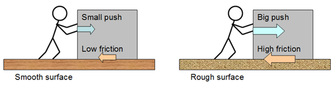
Instead of pushing a box, now think of wind blowing over that surface. Like with the box, the wind encounters less resistance over smooth surfaces and more resistance over rough ones. Friction is always going to slow down our air parcel, thereby always acting exactly opposite to the direction the wind is blowing. The degree of eddy viscosity in the atmosphere depends on the roughness of the surface below. On a particularly windy day, think – are you struggling to hold on to your hat if you are in a wide-open field or under a dense forest canopy? You feel the wind far more in open, flat areas because the relatively smooth surface that lacks irregularities does little to impede the flow of air. However, you are more sheltered under a canopy of trees since they present greater frictional resistance to the wind due to the increased turbulence caused by the objects in the wind’s way.

You can readily see this effect in weather maps, too. For example, above is the output from a model simulation depicting Hurricane Irma's landfall. I don't need to actually show the outlines of the state of Florida; you can figure it out just by looking at where the wind speed changes due to air moving from flowing over the nice, smooth ocean to the much higher friction land. The smooth ocean surface offers little in the way of friction, but the land (with its associated vegetation, buildings, etc.) exerts far more friction on the winds.
As we move above the Earth's surface, away from the primary sources of frictional resistance caused by obstacles on the ground (or the ground itself), this eddy viscosity diminishes rapidly, leading to an increase in horizontal wind speed with altitude. This transition becomes particularly noticeable at an average altitude of approximately 1000 meters (3300 feet) above the surface – above this, friction's influence is essentially negligible. The region in the atmosphere where frictional resistance is most pronounced is referred to as the atmospheric boundary layer.
Gravity
You probably remember countless physics assignments in high school where you had to draw forces on an object (remember a block on an incline?) and instinctually just drew a downward-facing arrow representing the gravitational force. Well, just like any other object with mass, air parcels are subject to the force of gravity, which is the attractive force between Earth and any object near it. Even though it is far less dense than the solids we interact with on a day-to-day basis, the fact that air is also subjected to gravity is a saving grace – without this effect, our atmosphere will escape to space, leaving us to struggle for survival in a vacuum.
Gravity causes objects to accelerate towards Earth's surface at an average rate of 9.8 m/s² (32.2 ft./sec.²). This is considered to be a “universal” constant, although it's important to note that this average assumes a perfectly spherical Earth with uniform mass distribution – this is actually not true. For example, the Earth slightly bulges out near the equator. It’s technically an oblate spheroid, slightly bulging at the equator due to its rotation. This bulge results in slightly lower surface gravity at the equator compared to the poles because the equator is farther from Earth's center of mass. If you stand in Costa Rica, you actually experience less gravity than if you were standing at the North Pole (although it’s imperceptibly small!)

Gravity always acts vertically downward on Earth and does not significantly impact horizontal winds, unlike the Coriolis force and friction. Gravity primarily influences vertical air motion, playing a fundamental role in creating buoyant forces. These forces drive the ascent and descent of air, seen in phenomena like updrafts and downdrafts in convection currents (e.g., thunderstorms) and the downhill drainage of cold, dense air.
In summary, four main forces are important for understanding motion in the climate system:
- The horizontal pressure gradient force, responsible for initiating air motion, continually tries to move air from high-pressure areas toward low-pressure regions.
- The Coriolis force arises from Earth's rotation, deflecting large-scale winds to the right in the Northern Hemisphere and to the left in the Southern Hemisphere. Its magnitude increases with latitude, reaching a maximum at the poles.
- Friction always opposes motion, acting in the opposite direction of the wind and increasing with surface roughness. It primarily affects winds close to the surface.
- Gravity exerts a vertical downward force on air and is critical for impacting upward or downward motions and the vertical structure of the atmosphere.
Quiz Yourself…
Atmospheric Cells and the Hadley Circulation
Atmospheric Cells and the Hadley CirculationPrioritize…
After completing this section, you will be able to:
- define general circulation and demonstrate understanding of a “cell” in the atmospheric circulation
- define a thermally-direct cell and how air rises, sinks, and moves either north or south based on where the atmosphere is warmer or cooler.
Read…
OK, let's start actually using those forces we just learned about to explain the general circulation of the climate system. The “general circulation” in a climate context refers to the large-scale movement of air that helps distribute heat and moisture across the Earth.
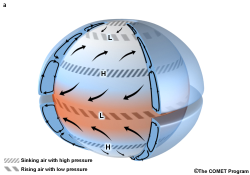
As previously discussed, equatorial regions receive intense solar radiation, more so than regions further north and south away from the equator. Without a mechanism to redistribute this heat, the equatorial regions would get hotter, and the higher latitudes colder than they currently are. The intense solar radiation in equatorial regions leads to a warm surface with warm moist air in the atmospheric column above it.
The extra warming at low latitudes fosters something known as convective instability, i.e., the unstable situation of having relatively light air underlying relatively heavy air. Where that instability exists, there is rising motion in the atmosphere as the relatively light (warm and moist) air rises above the heavier (colder and drier)air.
Take a look at this YouTube video detailing an experiment you can do at home on your stove top that illustrates the concept. Now imagine the stove top as the equator – instead of the burner heating up, it’s the Earth’s surface due to the copious amounts of solar radiation!
Video: Warm Air Rises - The Spinning Paper Plate (2:37)
Warm Air Rises — The Spinning Paper Plate
Presenter: Hello, I am Jared, back with some more experiments on the idea that warm air rises, heat rises. It is difficult to see that. Kids have that schema, that background knowledge that warm air rises. They have seen hot air balloons, they have gone through that fire company training, you know, of smoke detectors up high because smoke rises. The smoke rises because the warm air is heated and it rises.
And just to get them to see that is really an interesting thing, and it is easy to do. So I have a paper plate, a Sharpie, and all I am going to do is draw a swirl pattern on that plate. Nothing pretty, I am going to start in the center, and I am going to show you what that looks like, taking my time. There is no exact pattern here, I am just going into a swirl... does not take long... to the edge... and I have a swirl. When I cut that out, I am going to be left with this. And when I hold it up, it is going to dangle down. I did snip the outer edge of the plate off because it would dangle, oh, a good two or three feet. So I snipped it off, and what I want to be able to do is hold this without getting my hand burned.
So I am going to take a simple straight pin drive it through, so the head of the pin is going to keep it from falling through, and I have this. Nothing is happening. This is surrounded by air, but it is not spinning. So what I need is, I need to heat some air to get it to rise. It is going to hit the bottom part of this wind spiral and actually start it turning. So I have a burner. I am going to turn the burner on, it is going to heat up. And the kids have seen this, they have looked down the blacktop road, and they could see the heat waves rising off of the road. So it is simple, this is just the way so they do not have to sit there and squint and try and see the rising heat waves.
They are going to be able to see the heat waves rising because the wind spiral is going to start spinning. So I am going to slowly make sure this is heating up. It is not super hot yet, so I am going to make sure, I am going to slide it over, and it is starting to spin! Again, not my Jedi mind powers making this thing spin. The air is heated, it is rising up, it is hitting the bottom of the wind spiral, and it is actually pushing it and rotating it. It stops- and there it is spinning- and it stops. Warm air rises. Thanks for watching!
This rising motion at the equator leads to what scientists call a cell. An atmospheric cell is a large-scale circulation pattern in the Earth's atmosphere, driven by temperature and pressure differences across latitudes. These cells involve the upward movement of warm and moist air, the downward movement of cooler and drier air, and the associated transport of air either northward or southward at different levels of the atmosphere.
The particular cell we’re discussing is called the Hadley circulation, named after George Hadley (1685-1768), a lawyer who, while not a climate scientist, developed an interest in weather patterns as a hobby.
The Hadley circulation can be thought of as a giant conveyor belt in the sky, responsible for redistributing heat and moisture across the planet. Near the equator, air at the surface warms and moistens as intense solar radiation is absorbed by surface ocean waters and land at these latitudes. This warm, moist, energetic air rises and ascends to a region known as the tropopause, about 17 kilometers above the surface at the equator. As the air rises, it cools and loses moisture to precipitation. At this altitude, the air begins to move poleward rather than continuing into the stratosphere. Eventually, the air sinks back toward the surface at higher latitudes.
As warm air rises near the equator and sinks at higher latitudes, it creates a pressure gradient near the surface, with lower pressure near the equator and higher pressure in the subtropics. In the figure below, “H” indicates areas of high pressure and “L” represents low-pressure regions. As we discussed earlier, air flows from regions of higher pressure to lower pressure. This pressure difference drives equatorward flow in the lower parts of the atmosphere (depicted by the gray lines labeled “surface flow”). The rest of the circulation, with its rising and sinking motion, is shown by the red and blue arrows.
In simple terms, at the surface, air flows from cooler, high-pressure regions toward warmer, low-pressure regions. To balance the surface flow, higher up in the atmosphere, the air flows from regions above warm surfaces to regions above cooler surfaces.
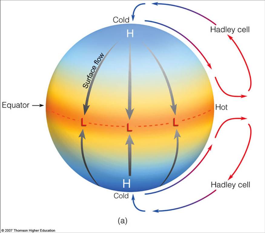
Here’s a simpler schematic that may clarify things. Notice that cells where warm air rises and cool air sinks are called thermally-direct cells, and the Hadley circulation is a prime example of this. This may seem intuitive, but since I’m pointing it out, you can probably guess that we’ll soon be discussing thermally indirect cells, where air is actually sinking in the warmer region!

I want to emphasize that this Hadley cell is always on – there is always more energy striking the Earth’s surface at the equator than the polar regions. It is like the “open 24 hours a day, 7 days a week, 365 days a year” player in the climate system. This is important for understanding the climate of tropical regions. The ascending part of the Hadley cell leads to rainy equatorial regions. The descending part of the Hadley cell, where air sinks back down to the surface, leads to clear skies and less rainfall in subtropical regions. Meanwhile, the lower branch of the Hadley cell circulation carries excess moisture from these subtropical areas back toward the equator. But more on this in a little while!
Quiz Yourself…
The Three Cells in the Atmosphere
The Three Cells in the AtmospherePrioritize...
After reading this section, you should be able to:
- describe the three main cells in the atmosphere and explain why we don’t just have one single atmospheric cell like we hypothesized.
- state where each cell is located and whether the cells are thermally-direct or thermally-indirect and how their rising and sinking motions can lead to broad latitudes of wet or dry climates.
Read...
However, what we observe in the atmosphere is a bit more complicated. There really isn’t just a single cell in the atmosphere like we hypothesized a little while ago. In fact, what we observe looks more like this below.
This is because the Earth is rotating. Without this rotation, things would be simple, just like we thought in the previous section! But unfortunately, Earth's rotation complicates matters…
To understand how this rotation impacts global circulation, let’s focus on the Northern Hemisphere for simplicity (the same general process happens in the Southern Hemisphere, but remember—the Coriolis force acts in the opposite direction there).
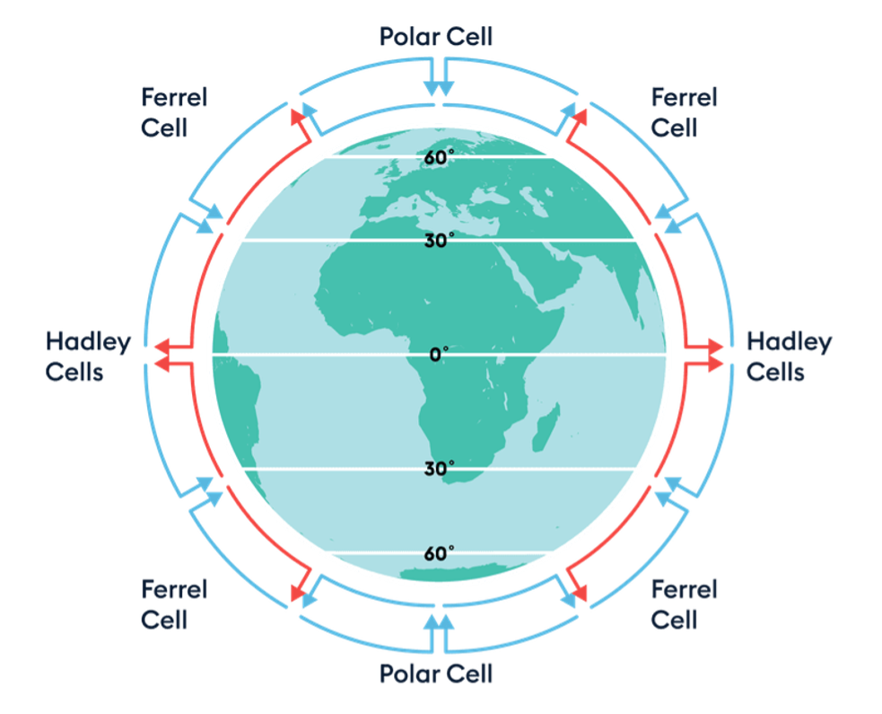
Recall that we mentioned the Coriolis force causes air to move to the right in the Northern Hemisphere. So, in our non-rotating Earth example, air rises at the equator and then moves directly toward the poles. However, since the Earth rotates, this air can’t travel in a straight line. Instead, it bends to the right as it moves from south to north. This bending starts turning the wind—first toward the northeast, and eventually toward the east. In short, this deflection prevents the Hadley cell from spanning the entire hemisphere; it only reaches about 30 degrees latitude. At this point, the air that rose in the tropics begins descending in a belt known as the "subtropics."
Within the subtropics, the descending air diverges, with some moving poleward and some equatorward. The air that flows back toward the equator near the surface also experiences the Coriolis force, bending to the right. This contributes to the formation of the surface trade winds, also called the easterlies.
Meanwhile, some of the air that descends in the subtropics moves north once it reaches the surface. From there, it forms another important circulation pattern known as the Ferrel cell, which operates between roughly 30 and 60 degrees latitude in both hemispheres. In the upper atmosphere of the Ferrel cell, air moving toward the equator is deflected westward by the Coriolis force. Air in the lower branch moving northwards is deflected to the east, producing the Westerlies. As a result, just as the easterly Trade Winds occur below the Hadley cell, the surface Westerlies are found beneath the upper branch of the Ferrel cell.
The Ferrel cell is relatively weak because it lacks both a strong heat source and a strong sink. This makes the airflow and temperatures within it more variable, which is why the latitudes it spans are sometimes referred to as the "zone of mixing.” The easterly Trade Winds in the Hadley circulation face few obstacles, as the Hadley cell is strong and undisturbed by large terrain features or high-pressure zones. In contrast, the weaker Westerlies of the Ferrel cell can be easily disrupted. For example, the passage of a cold front can change wind direction in a matter of minutes. While surface winds in the Ferrel cell are more variable, winds higher up, away from terrain disruptions, remain predominantly westerly. A low-pressure zone at 60° latitude moving toward the equator, or a high-pressure zone at 30° latitude moving poleward, can accelerate the Westerlies. A strong high moving poleward may bring westerly winds for several days.
Further poleward, closer to the poles, we find the Polar cell, which operates between approximately 60 and 90 degrees latitude in both hemispheres. In the Polar cell, cold air descends and moves toward lower latitudes. As it moves toward the equator, it’s deflected by the Coriolis force, creating polar easterlies.

The Polar cell is a simpler system driven by strong convection. Though colder and drier than equatorial air, the air masses at 60 degrees latitude are still warm and moist enough to drive convection and create a thermal loop. Here, air rises to the tropopause (about 8 km at this latitude) and moves poleward. As it does, the upper-level air is deflected eastward by the Coriolis force. When the air reaches the polar regions, it has cooled through radiation to space and becomes denser than the underlying air, causing it to descend and create a cold, dry high-pressure area. At the polar surface, the air moves away from the pole, replacing the air that rose earlier, completing the polar circulation cell. As this surface air flows toward the equator, it is deflected westward again by the Coriolis force, creating the polar easterlies. These winds flow from northeast to southwest in the Northern Hemisphere and from southeast to northwest in the Southern Hemisphere.
Quiz Yourself…
As we learned recently, Hadley and Polar cells are termed thermally direct because their circulation patterns are primarily driven by temperature differences. In the case of the Hadley cell, warm moist air rises at the equator due to intense solar heating, creating a low-pressure zone, while cooler drier air descends at higher latitudes, particularly around 30 degrees latitude, creating a high-pressure zone. This temperature contrast sets up a direct circulation pattern where air moves from regions of high pressure to low pressure (equator to subtropics). Similarly, in the Polar cell, cold, dry dense air descends at the poles due to lower temperatures, creating a high-pressure zone, while warmer, moist buoyant air rises at lower latitudes, creating a low-pressure zone. This temperature contrast also establishes a direct circulation pattern from high to low pressure (poles to mid-latitudes).
On the other hand, the Ferrell cell is termed thermally indirect because its circulation is not primarily driven by temperature differences. Instead, it exists because of the interactions between the Hadley and Polar cells. The Ferrell cell is located between these two larger cells, around 30 to 60 degrees latitude in both hemispheres. The descending air in the subtropics from the Hadley cell and the rising air in the mid-latitudes from the Polar cell set up a pattern where warmer air is sinking and cooler air is rising – the opposite of what you’d expect based on what we discussed earlier – making it thermally indirect.
The Hadley cell and the Polar cell exhibit similarities in their thermal directness, meaning they are both primarily driven by temperature differentials. Their thermal characteristics dictate the weather patterns within their respective regions. The Hadley circulation transports energy poleward from the equator out to about 30 degrees of latitude. Out to 15 degrees of latitude, it is the dominant mode of poleward energy transport, and from 15 degrees to 30 degrees other (transient) weather processes come to dominate it. Similarly, the thermally direct Polar cell also constantly works to transport energy poleward, though as a percentage of the total energy transport it is swamped by (transient) weather events.
The perpetual succession of highs and lows, a common occurrence in the daily lives of those residing in mid-latitudes under the influence of the Ferrel cell, is virtually absent beyond the 60th and below the 30th parallels. There are noteworthy exceptions to this general pattern; for instance, over Europe, unstable weather patterns extend as far north as the 70th parallel.

But it’s worth noting that these cells go far beyond just distributing heat -- they play a pivotal role in shaping the global climate by establishing semi-permanent high and low-pressure systems.
In the region of the Hadley cells where air rises, such as the equatorial rainforests, low-pressure zones are prevalent. The rising air cools and condenses, resulting in abundant rainfall characteristic of these areas.
Conversely, areas at the surface under the branches of the Hadley cells where air descends experience high-pressure conditions – this leads to drier climates akin to desert regions.

Watch this video, which synthesizes everything we just talked about! (3:35 minutes)
Narrator: The last video showed that different parts of the Earth heat up differently, with the equator receiving more rates of heat from the Sun than the poles, and the purpose of global circulation is to redistribute this heat. If the Earth did not rotate and was a simple landmass with no oceans, we would have a single circulatory cell in each hemisphere, where hotter air would rise at the equator and flow toward the poles. The air would sink as it cools and then return towards the equator. But the unequal distribution of land and ocean, and the speed of the Earth's rotation, complicates this circulation system, giving us a 3-cell pattern which exists in both the northern and southern hemispheres.
The largest cells are the Hadley cells; at the equator, the warmer, less dense air rises. It rises to a height of about 18 kilometers and spreads out underneath the tropopause. The tropopause acts as a lid to the lowest part of our atmosphere, which contains all of our weather. The warm air spreads out towards the poles, gradually cooling and sinking as it moves before descending to the surface and flowing back to the equator. The smallest cells are the polar cells; cold, dense air descending in the polar regions flows at low levels to about 60 to 70 degrees north or south. As the air leaves the polar regions, it starts to warm and rise, returning to the poles at high levels.
Between the Hadley and polar cells are the Ferrel cells. Unlike the other cells, the Ferrel cells are not driven by temperature. These cells flow in the opposite direction to the Hadley and polar cells, acting like a gear. These circulating cells not only transport heat from the equator to the poles but also result in semi-permanent areas of high and low pressure due to the rising and descending parts of the circulation cells, giving us our climatic zones. Where air is rising, an area of low pressure is created, so these areas see much more rainfall. This is why the largest areas of rainforests are found near the equator, and why the United Kingdom has a relatively wet climate. Where air is descending, an area of high-pressure forms, giving largely clear skies and little rainfall, which leads to the desert regions.
But not all deserts are hot. Antarctica sits under the descending branch of the polar cell and is also classed as a desert. With more precipitation falling in the Sahara, Antarctica is the largest and driest desert. Overall, take a look at our video on atmospheric pressure for more on how pressure leads to weather. Our next video shows how the rotation of the Earth gives us jet streams and prevailing winds.
One fascinating aspect of this phenomenon is the diversity of deserts worldwide. While deserts are often associated with scorching temperatures, the designation extends beyond heat alone. Antarctica, for instance, stands as a stark testament to this notion. Despite its frigid temperatures, Antarctica qualifies as a desert due to its exceptionally low precipitation levels associated with the descending air in the polar cell. This anomaly underscores the nuanced interplay between atmospheric circulation and climatic conditions.
Quiz Yourself…
Atmospheric Climate Zones
Atmospheric Climate ZonesPrioritize…
After reading this section, you should be able to:
- Define the intertropical convergence zone and how it is related to the Hadley circulation.
- Define the major climate zones of the Earth.
- Explain how climate zones are related to the large-scale cells.
- Be given a climate zone and qualitatively explain why it arises.
Read…
Let’s explore these climatic zones in more detail. In the last section, we took a simplified view, assuming that conditions were uniform from east to west. However, in reality, the climate system is far more complex. Let's now bring together everything we've learned, using a more nuanced understanding of the Earth's diverse climates.
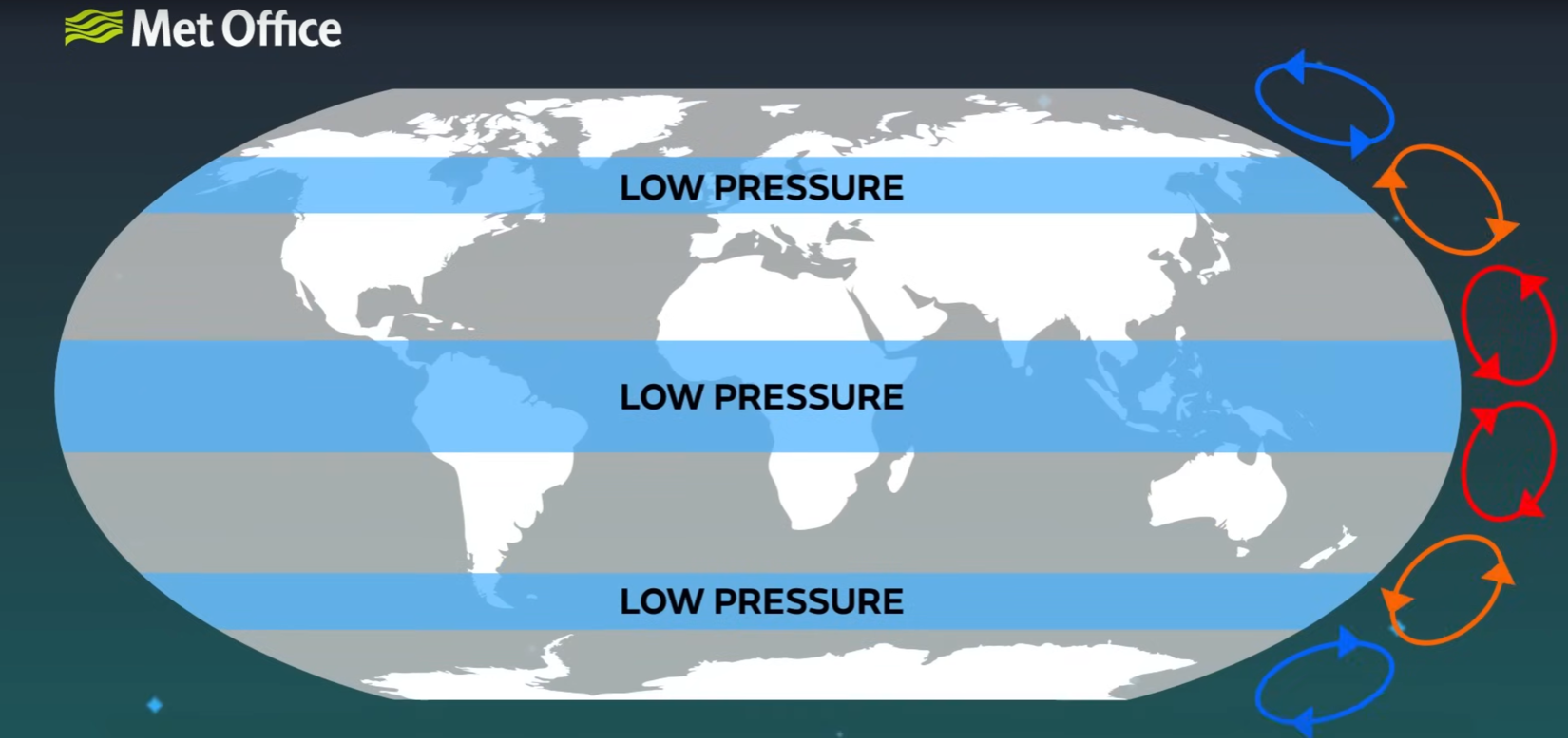
We know that the distribution of solar energy (or insolation) across the Earth’s surface varies with the seasons. As the Sun shifts north and south of the equator throughout the year, so do climate patterns. This seasonal migration, which occurs between approximately 23.5°S and 23.5°N, defines the tropics. Within this zone, solar heating is intense, causing air to rise. This rising motion forms the basis of the Hadley circulation, a major driver of global atmospheric motion, that we previously discussed a major.

Where this tropical air rises, we find a zone of low-pressure and frequent rainfall, known as the Intertropical Convergence Zone (ITCZ). You can think of the ITCZ as the “center” of the Hadley circulation, where that rising motion is the strongest. The ITCZ is not fixed; it moves north and south with the Sun’s seasonal journey, bringing wet and dry seasons to different regions of the tropics. This constant shifting creates dynamic weather patterns that influence life in tropical regions.
As the air rises in the ITCZ, it cools and spreads towards the poles, descending in the subtropics—the area between 23.5° and 35° latitude in both hemispheres. This descending air creates a band of high pressure, characterized by dry, stable conditions. It is no coincidence that many of the world’s deserts are located in the subtropics, such as the Sahara in the Northern Hemisphere and the Atacama in the Southern Hemisphere. These regions are marked by minimal rainfall and clear skies, driven by the sinking motion of the air, which inhibits cloud formation.
Beyond the subtropics, in the mid-latitudes (roughly 35° to 60°), the air again begins to rise, but for a different reason. Here, warm air from the subtropics collides with colder air from the polar regions. This clash, known as the polar front, is a zone of active storm formation. The meeting of these contrasting air masses leads to the development of the polar jet stream, a fast-moving current of air that circles the globe at these latitudes, directing storm systems and influencing weather patterns in the temperate regions. Storms across the latitudes of the Ferrell cell, which dominate the mid-latitudes, help transport heat between the subtropical high-pressure zones and the polar front, contributing to the distinct seasonal variations in this region.
The temperate region can be broken into a warm and a cool temperate zone. The warm temperate zone (roughly 35° to 45° latitude) experiences mild winters and hot summers, while the cool temperate zone (from about 45° to 60° latitude) sees colder winters and milder summers. As we move poleward, the influence of tropical air decreases, and polar air masses become more frequent, shaping the cooler climates.
Further poleward, the Polar Cell governs the atmospheric circulation over the polar regions. This circulation pattern reinforces the cold, dry conditions typical of these latitudes, where descending air creates high-pressure systems over the poles, completing the balance of heat transport from the equator to the poles. At the highest latitudes, beyond 60°, we reach the polar regions. Here, solar radiation is weak or absent for extended periods, particularly during the polar night, which can last for months. This results in cold temperatures and vast expanses of ice, characteristic of the Arctic and Antarctic regions. The air here is cold and dense, and surface pressure tends to be higher, although the polar regions are also subject to sporadic low-pressure systems that can bring snow and cold winds.
While the above image is static, it's important to remember that these belts of high and low atmospheric surface pressure, and the associated patterns of atmospheric circulation, also shift south and north over the course of the year in response to the heating by the Sun. You can explore the atmospheric patterns using the following animation (1:04):
Atmospheric Patterns Animation
A flat map of Earth with atmospheric circulation patterns overlaying the geographical features. The equator is centrally located, with the Tropic of Cancer and the Tropic of Capricorn marked to the north and south. Symbols for high (H) and low (L) pressure systems are scattered across the map, with “subtropical highs” prominently labeled near the Tropics. Blue circles with blue 'L's are near the poles, labeled as “Polar front.” On the sides, red and blue arrows depict the Hadley Cells with warm air rising and cool air descending, labeled as “Hadley Cells” and “Polar front”. Below the map, a timeline shows the months of the year, suggesting a seasonal progression of these patterns. Interactive buttons below the map include options to hide or show different features like the Hadley Cells, ITCZ, pressure systems, and precipitation. When selected, a wavy purple line meandering across the equator represents the Intertropical Convergence Zone (ITCZ).
We are ready to put all the pieces from the last few lessons together to describe the general circulation of the atmosphere! Let's work through what we've just learned step-by-step…
- We’ve established that there is an imbalance in the Earth's energy budget: the tropics receive more incoming shortwave solar radiation than they emit as longwave radiation, while the poles emit more longwave radiation than they absorb of the shortwave solar radiation. This results in a heat surplus in the tropics and a heat deficit near the poles. The atmosphere and ocean act together to redistribute this energy, relieving the imbalance by moving heat from where it is in excess to where it is lacking. This process, known as heat advection, is essential to maintaining the planet's energy equilibrium.
- We’ve already touched on one key player in this heat transport: the Hadley Cell. Through the rising of warm air at the equator and its descent in the subtropics, the Hadley circulation helps transfer energy poleward. But this is just one part of the story. Beyond the tropics, other wind patterns come into play, especially in the mid-latitudes, to ensure heat is distributed toward the poles.
- In addition to horizontal heat advection, there is also vertical heat transport within the atmosphere. This occurs as warm air rises in areas of low-pressure and cool air sinks in areas of high pressure. This vertical movement of air helps redistribute heat from the surface to higher altitudes, contributing to the overall balance of energy in the climate system. Rising air transports heat away from the Earth's surface, while sinking air brings cooler air down, particularly in the subtropics and polar regions.
- In the extratropics, wind patterns are driven by the interaction between the pressure gradient force (the difference in pressure between high and low-pressure systems) and the Coriolis force, a deflecting force due to the Earth's rotation. The Coriolis force deflects winds to the right in the Northern Hemisphere and to the left in the Southern Hemisphere, creating westerly winds in the mid-latitudes. They blow from west to east between the subtropical high-pressure zones and the subpolar low-pressure zones near the polar front. These westerlies strengthen with altitude, giving rise to the jet streams, fast-moving currents of air in the upper atmosphere that influence weather patterns across the globe.
- In contrast, winds in the tropics tend to blow from east to west, known as easterly trade winds. These trade winds are a product of the same forces but within the tropical pressure system.
- At the Earth’s surface, the situation becomes slightly more complex due to friction. Friction causes winds to spiral inward towards low-pressure centers (a process called convergence) and outward from high-pressure centers (divergence). Convergence in low-pressure areas is associated with rising air, while divergence in high-pressure areas is associated with sinking air. These dynamics shape the structure of mid-latitude weather systems.
- The polar front, the boundary where cold polar air meets warmer subtropical air, is a particularly dynamic region. The contrast between these air masses gives rise to extratropical cyclones—large-scale storm systems that dominate mid-latitude weather. These cyclones are powered by baroclinic instability, which occurs when the temperature difference between air masses drives instability and storm formation. As these cyclones lift warm air along frontal boundaries (such as warm fronts and cold fronts), they effectively mix air masses and transport heat toward the poles, helping to balance the energy deficit at higher latitudes.
Congrats! While the actual climate system is a little more complicated than this, you can now explain key climate regions on Earth and why they exist. You should explore the resulting large-scale pattern of circulation of the global atmosphere in the following animation (1:05) -- see how many things you can tie to what we just covered above!
Circulation of the Global Atmosphere showing the idealized Hadley cell circulation, mid-latitude and high latitude components and upper atmosphere flow.
This video shows a diagram representing the Earth with an emphasis on atmospheric circulation, specifically the idealized Hadley Cell Circulation. A cross-section of Earth shows the equator at the center, flanked by the Tropic of Cancer and the Tropic of Capricorn. The Hadley cells are depicted as large blue loops, with red arrows indicating warm air rising at the equator and blue arrows showing cool air descending at the tropics. The letters 'H' and 'L' indicate areas of high and low pressure, respectively.
As the animation progresses, additional atmospheric layers are added. The labels ‘ITCZ’ (Intertropical Convergence Zone), 'trade winds', 'westerlies', and 'polar easterlies' denote different wind patterns. The Hadley cells, now interacting with other components, create a dynamic representation of the Earth’s atmospheric circulation. Red and blue arrows again show the direction of air movement, while fluffy white shapes at the poles and a line marked 'Polar front' suggest colder climates and boundary areas in the atmosphere.
Quiz Yourself…
Ocean Circulation: Wind-Driven
Ocean Circulation: Wind-DrivenPrioritize…
After reading this section, you should be able to:
- describe how friction from winds in the atmosphere drives circulation patterns in the ocean.
- define what a gyre is and explain why the western side of the North Atlantic and North Pacific Ocean basins are warm while the eastern sides are cool.
- define the Ekman spiral and how wind blowing across the ocean surface can pump cool, nutrient-rich water upward in specific parts of the ocean.
Read…
While we have focused primarily on the atmosphere thus far, the oceans, too, play a key role in addressing the radiation imbalance by transporting heat from lower to higher latitudes. The oceans also play a key role in both climate variability and climate change, as we will see. In fact, oceans transport as much as a third of the planet's excess heat from the equator towards the poles, playing a massive role in regulating global temperatures! We will discuss ocean circulation currents, which refer to the continuous movement of seawater in the oceans, driven by various factors including wind, temperature, density differences, and the Earth's rotation. There are two primary components of the ocean circulation. Let's focus on the first one -- the wind-driven circulation.
Wind-Driven Circulation
The first component is the horizontal circulation, characterized by wind-driven ocean gyres. A gyre is a large system – typically circular or spiral-shaped -- of circulating ocean currents, typically spanning an entire ocean basin. These gyres are formed – well, exactly how they sound. Imagine these gyres like planetary-sized whirlpools, with water slowly circulating around an ocean basin like a giant, slow-moving pinwheel. Wind in the atmosphere pushes on water and moves it around. This is not unlike if you take your hand and drag it across a lake – as you do, you induce a current on the surface. This is the frictional force we talked about earlier at work.

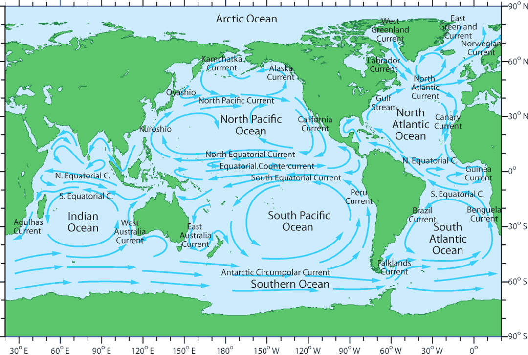
The major surface currents you may have heard of are associated with the ocean gyres. These include the warm poleward western boundary currents such as the Gulf Stream, which is associated with the North Atlantic Gyre, and the Kuroshio Current associated with the North Pacific Gyre. These currents bring warm water from regions closer to the equator and move them poleward. It’s the main reason why it’s relatively pleasant to swim off the Outer Banks in North Carolina, even if the air temperature is relatively chilly.
Check out the map of sea surface temperatures below – that stripe of red, orange, and yellow (warmer waters) moving along the coast and out into the Atlantic Ocean is the Gulf Stream, which is the Atlantic’s western boundary current.

These gyres also contain corresponding cold equatorward (i.e., from higher latitudes to lower latitudes) eastern boundary currents such as the Canary Current in the eastern North Atlantic and the California Current in the eastern North Pacific. These are the opposite of what we just discussed, as they are currents that take cool water towards tropical regions. If you’ve visited Los Angeles, California and gone swimming in the Pacific Ocean, you may have been surprised at how cold the water felt even if it was 85 degrees outside. That is largely due to the eastern boundary current moving southward along the United States’ west coast. So warm water on the east coast, cool water on the west coast -- now you can impress your friends by telling them it's all due to ocean gyres!
Similar current systems are found in the Southern Hemisphere, where the horizontal patterns of ocean circulation mirror those in the Northern Hemisphere. This symmetry is driven by the alternating patterns of wind as a function of latitude, which are part of the broader atmospheric circulation we discussed quite recently! The trade winds blow predominantly from the east in the tropics, while the westerlies prevail in the mid-latitudes. These wind patterns exert a significant influence on ocean currents, pushing surface waters in predictable directions. Check out the below map of global surface currents – in general, water moves from east to west close the equator (pushed by the trade winds) and west to east in the mid-latitudes (pushed by the prevailing westerlies). To close the loops, water must move north or south in the regions we discussed above!
Quiz Yourself…
Ekman Pumping and Upwelling
Before moving on, let’s touch on an important phenomenon in ocean circulation closely tied to the wind-driven circulation.
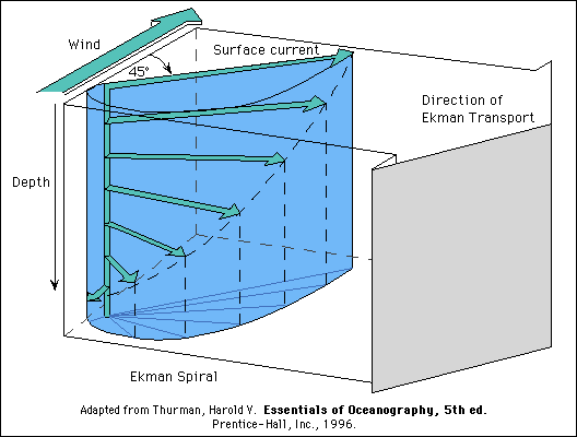
We just talked about how the wind “drags” ocean water along with it. Now, you’d probably just expect that the water just starts moving along with the wind, right? But it doesn't happen exactly like that because the Earth is rotating. This rotation makes things on the Earth's surface, like ocean currents, move to the right in the Northern Hemisphere and to the left in the Southern Hemisphere. Aha, the Coriolis force is back!
Now, this is where it gets a bit twisty … literally! The wind starts pushing the water, but due to the Earth’s rotation, the water doesn't just move in the direction of the wind; it moves at an angle to it. And each layer of water below the surface moves at a slightly different angle than the one above, creating a kind of spiral staircase of water movement under the sea. This pattern is what we see in the image as the “Ekman spiral.” Take a look at the image below – the little green arrows represent the spiraling ocean direction with depth.
Because of this spiraling effect, the water on the surface doesn't just go in the direction the wind is blowing. Instead, there's what we call the “Ekman transport,” which is the average movement of all these spiraling layers of water. In the end, this means that the water at the surface tends to move at a 90-degree angle to the direction of the wind. If the wind is blowing from north to south, the water on the surface will end up moving to the west in the Northern Hemisphere and to the east in the Southern Hemisphere.
As surface water is pushed away by the wind-induced Ekman transport, a void is created. Nature abhors a vacuum, so deeper water from below rises to fill this void. This upward movement of deeper water to replace the surface water that has been transported away is known as Ekman pumping.
Ekman pumping is a bit like the ocean taking a breath, since it brings water from deeper down to the surface. It plays a role in distributing heat throughout the ocean, which helps to moderate the global climate. The upwelling water is typically cooler and can lower sea surface temperatures. Done over large enough areas and for a long enough time, it can influence atmospheric conditions and alter weather patterns over vast areas. Beyond its climatic impact, Ekman pumping serves as an underwater nutrient source. As it uplifts water from the abyss, it carries with it various nutrients that have been locked away in the dark. Upon reaching the sunlit upper layers, they fertilize the water, providing a bounty for phytoplankton, the tiny but mighty organisms that support the marine ecosystem. This process not only fuels phytoplankton, but it’s the reason coastal areas like California are teeming with marine life—from fish to dolphins to the flocks of seabirds you see diving for a meal.
Coastal Upwelling
Relatedly, coastal upwelling is a phenomenon that occurs along coastlines where winds blow parallel to the shore, driving surface water away from the coast. This offshore movement of surface water creates a void along the coastline, which is swiftly filled by deeper water welling up from below, a process known as upwelling.

The primary driving force behind coastal upwelling is wind stress exerted on the ocean surface. Along many coastlines, particularly those with strong, persistent winds such as the west coasts of continents, prevailing winds blow parallel to the shore, known as alongshore winds. These winds generate a phenomenon known as Ekman transport, where surface water is pushed offshore due to the Coriolis effect.
As surface water moves away from the coast, it is replaced by deeper, colder, and nutrient-rich water that wells up from below. This upwelled water originates from deeper layers of the ocean, where nutrient concentrations are typically higher due to biological processes and the accumulation of organic matter.
Coastal upwelling and Ekman pumping, though related, are distinct processes in ocean circulation. Ekman pumping primarily results from wind-induced Ekman transport, where friction between wind and the ocean's surface causes surface water to diverge, allowing deeper water to rise and replace it. This process occurs not only along coastlines but also in open ocean regions where wind-driven surface currents diverge. In contrast, coastal upwelling specifically occurs along coastlines where persistent winds blow parallel to the shore, driving surface water offshore and allowing deeper, nutrient-rich water to upwell. While both processes involve the upward movement of nutrient-rich water to the surface, coastal upwelling is more localized and directly linked to coastal wind patterns, whereas Ekman pumping operates on a broader scale.

In regions where coastal upwelling and Ekman pumping coincide, the combination of nutrient inputs from deep water upwelling and surface water divergence leads to exceptionally high levels of biological productivity. Phytoplankton thrive in these nutrient-rich waters, supporting abundant fisheries and diverse marine ecosystems.. Nutrient inputs from upwelling fuel the growth of phytoplankton, which form the base of the marine food web. This abundance of primary producers supports thriving populations of zooplankton, fish, seabirds, and marine mammals. In the end, these ocean currents don’t just move water!
Quiz Yourself…
Thermohaline Circulation
Thermohaline CirculationPrioritize…
After reading this section, you should be able to:
- define what the thermohaline circulation is and what “thermo-” and “haline-” mean in the context of ocean dynamics.
- qualitatively describe the motions of the thermohaline circulation and how it moves warm and cold water (and therefore energy) in the climate system.
Read…
In the last lesson, we mentioned there were two components to ocean circulation. We spoke extensively about the surface gyres, Ekman pumping, and upwelling. All of these are driven by wind “pushing” and “pulling” on the ocean surface. So what is the second component of the circulation?
An important additional mode of ocean circulation is the thermohaline circulation, which is sometimes referred to as the meridional overturning circulation or MOC for short. The term “thermohaline” combines two key components: “thermo” refers to temperature (how warm or cold the water is), and “haline” refers to salinity (how salty or fresh the water is). Therefore, “thermohaline” describes ocean currents and processes that are driven by differences in water temperature and salinity. The circulation pattern is shown below:
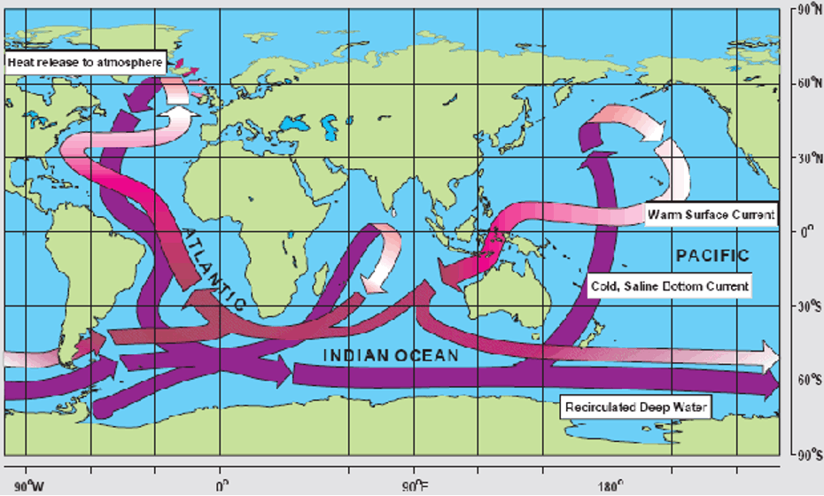
The therrmohaline circulation functions differently from the surface wind-driven currents we just learned about. Instead of horizontal movements across the ocean’s surface, thermohaline circulation involves a vertical flow pattern that spans the ocean’s depths.
Much like the Hadley circulation in the atmosphere, the thermohaline circulation can be thought of as a giant conveyor belt moving water up and down throughout the ocean. In the North Atlantic, near the pole, water becomes very cold and salty, making it denser and causing it to sink deep into the ocean. This sinking action creates a sort of vacuum, pulling water from other regions to replace it. To balance the water being pulled down, more water must flow in from elsewhere—otherwise, we’d end up with a giant divot in the center of the Atlantic!
In contrast, in warmer tropical and subtropical regions, like the Indian and Pacific Oceans, water tends to be warmer and less salty. This lighter, less dense water rises to the surface to fill the gaps left by the sinking cold water in the North Atlantic.
The main driving forces behind this circulation are differences in water density, primarily due to variations in temperature and salinity. Similar to the atmosphere, warmer water is less dense and tends to rise, while colder, saltier water is denser and sinks.
This balance of rising and sinking water plays a crucial role in regulating Earth’s climate by redistributing heat. It acts like a massive heat pump, moving warmth from the tropics toward the poles, helping to moderate temperatures in different regions.
Take a look at the schematic above. It’s worth mentioning that this is a somewhat simplified view of the actual vertical circulation patterns in the ocean—they are, in reality, much more complex. Still, you get the idea of how this circulation resembles a conveyor belt.
You might also notice, “Hey, I see the Gulf Stream in both sections!” You know, that current that is moving towards the north off of the eastern half of the United States. But hold on—that’s not quite right. The Gulf Stream is primarily driven by winds, not by the temperature or salinity of the water. When we talk about the thermohaline circulation, the northward extension in the North Atlantic is better known as the North Atlantic Drift. Like the Gulf Stream, this current also involves the net transport of warm surface waters to higher latitudes in the North Atlantic. Ultimately, the goal is to transfer that extra energy from the tropics to the poles!
Quiz Yourself…
Thermohaline shutdown?
Hopefully, I’ve convinced you by now that ocean currents, including the thermohaline circulation, play a crucial role in redistributing heat across the globe.
Within the thermohaline circulation, there are various components, much like the different currents we discussed in the context of wind-driven circulation. One of the most important of these is the Atlantic Meridional Overturning Circulation (AMOC). As we saw earlier, the North Atlantic Drift—a key part of AMOC—carries warm surface waters from the tropics to the North Atlantic, where they cool and sink, forming a deep ocean current that flows southward. This movement helps redistribute heat globally, influencing weather patterns and climate conditions, especially in regions like northern Europe.
Recent research suggests that AMOC may be approaching a “tipping point” where its behavior could change dramatically. Previous studies indicate that AMOC has two stable modes: a “strong” mode, which efficiently transports warm water into the North Atlantic, moderating the climate of northern and Western Europe, and a “weak” mode, where this transport is significantly reduced. Some scientists believe that current conditions may be pushing AMOC towards a transition from its strong state to a weaker one, leading to numerous—sometimes sensational—news articles warning of a potential climate crisis.
This possible shift to a weaker AMOC state is largely driven by the influx of cold, fresh water from the melting Greenland ice sheet (we’ll delve deeper into this topic in a few lectures). This freshwater disrupts the thermohaline circulation by reducing the salinity and density of the ocean water, which in turn weakens the sinking motion in the North Atlantic. If AMOC slows down, less heat will be transported to the North Atlantic, reducing its moderating effect on the climate of northern and Western Europe. As a result, these areas could experience colder conditions that are more typical of regions at similar latitudes, like Canada and Russia. Additionally, decreased heat transfer to the North Atlantic could lead to further warming in the southern Atlantic and surrounding areas. While the most significant impacts are expected in regions directly influenced by AMOC, broader changes in global temperature and precipitation patterns are also anticipated.
One thing worth noting is that it is best to think of these potential changes as a “tipping point” rather than a true collapse. For example, in the 2004 movie “The Day After Tomorrow,” the AMOC circulation plays a key role!
Clip from Day After Tomorrow
Newscast announcer: What you're seeing is what's left of downtown Los Angeles.
Speaker 1: Hey, man, I just got off the phone from my mom.
Speaker 2: Um, Excuse me, you guys. I'm really sorry, but we need to change the channel.
Newscast announcer: The FAA has grounded all air traffic in the United States. Unfortunately, the order came too late for two planes that were brought down by severe turbulence in the Midwest. The first flight-So much for one in a billion.
Tom: All right, all right, listen up, everybody. Listen up, please. We've got a lot of work to do, and we don't have much time, so let's get started, please. Vorsteen.
Vorsteen: All our grid models are worthless.
Booker: I don't think grid models are going to be a lot of help here. The Canadians are reporting tremendous circulation moving down from the Arctic. In Siberia, there's a low pressure system unlike anything we've seen, and Australia just saw the strongest typhoon ever recorded.
Lanson: Hang on, are you saying that these things are interconnected?
Booker: We have to consider the possibility.
Lanson: The only force strong enough to affect global weather is the sun.
Tom: What's NASA have to say?
Janet: We've already checked. Solar output is normal.
Jack Hall: What about the North Atlantic current?
Speaker: What about it?
Jack: I got a call last night from Professor Rapson at the Headland Center. He thinks the current has changed.
Booker: Come on, Jack. How could that be?
Jack: The current depends upon a delicate balance of salt and fresh water.
Tom: We all know that.
Jack: Yes, but no one has taken it into account how much fresh water has been dumped into the ocean because of melting polar ice. I think we've hit a critical desalination point.
Janet: It would explain what's driving this extreme weather.
Jack: Headland had some pretty convincing data. They've asked me to feed it into my paleo-climate model to track the next set of events.
Tom: Hold on, Jack. Are you suggesting these weather anomalies are going to continue?
Jack: Not just continue. Get worse. I think we're on the verge of a major climate shift.
Jack: Tom, what are you going to tell the administration?
Tom: What do you expect me to tell?
Jack: The government has to start making long-term preparations now.
Tom: Jack, all you have is a theory.
Jack: Well, then give me the mainframe and let me prove it.
Tom: No……You have 48 hours.
Janet: Professor Hall. Yes. I think your theory may be correct. Go off with me. Just a few weeks ago, I monitored the strongest hurricane on record. The hail, the tornado, it all fits. Can the model you're working on factor in storm scenarios?
Jason: We haven't had the time.
Janet: Maybe I can help.
Jack:
Welcome aboard.
Janet: Thanks.
Jason: Hi, I'm Jason.
Wow, the collapse of this circulation resulted in incredible and immediate shifts in day-to-day weather! Hail in Tokyo, tornados in Los Angeles, planes and helicopters “flash freezing” and falling out of the sky. Do not worry; this is highly sensationalized! Even relatively “abrupt” changes in AMOC do not happen overnight; they take years to decades to become apparent due to the ocean's size and the timescales at play. There is also no evidence that a slowdown of the AMOC (like that in the movie) would lead to global anomalous weather events that cause immediate and severe harm around the world.
However, this does not mean changes in AMOC would not result in societal impacts. In reality, the effects of such changes would be more gradual and localized, potentially altering weather patterns and marine ecosystems in specific regions rather than triggering instant, catastrophic consequences on a global scale. Despite the concerns raised by recent research, uncertainties remain regarding the specifics of AMOC transitions and the exact timing of potential collapses. There remain ongoing debates within the scientific community and the need for further research to better understand the implications of AMOC changes.
Quiz Yourself…
Summary
SummaryRead...
Let’s cover what we learned in this lesson!
- The motion of air and water in the climate system is driven by four main forces:
- The pressure gradient force initiates wind by moving air from high to low pressure areas.
- The Coriolis force deflects wind to the right in the Northern Hemisphere and to the left in the Southern Hemisphere due to Earth’s rotation.
- Friction slows down winds near the surface, especially over rough terrain, but decreases with altitude.
- Gravity drives vertical air motion, influencing updrafts and downdrafts, critical for storms and other weather phenomena.
- These forces combine to create three main atmospheric circulation cells:
- The Hadley cell circulates warm air up at the equator and down at the subtropics, leading to tropical rainforests and desert climates. It is thermally-direct.
- The Ferrel cell mixes warm and cool air in the mid-latitudes, resulting in variable weather patterns. It is thermally-indirect.
- The Polar cell circulates cold air around the poles, creating polar deserts.
- These circulation cells define Earth’s major climate zones: wet tropics, dry deserts, and polar regions.
- Wet tropics are shaped by the constant rising of warm, moist air at the equator, leading to frequent rainfall and lush vegetation.
- Deserts are formed by subtropical high-pressure zones where dry air descends and suppresses precipitation.
- Mid-latitude temperate zones experience variable weather due to the interaction between warm tropical air and cold polar air, resulting in four distinct seasons.
- Polar deserts are created by cold, descending air that limits moisture and precipitation, resulting in icy conditions.
- Oceans also play a key role in climate regulation:
- The wind-driven circulation is precisely what it sounds like – wind in the atmosphere pushes ocean water. Included in this circulation are ocean gyres moving warm water from the tropics to higher latitudes, impacting regional climates.
- The thermohaline circulation or “ocean conveyor belt” moves water based on temperature and salinity differences, redistributing heat globally.
Understanding these systems is crucial for grasping how heat and moisture move around the planet, shaping both local weather and global climate patterns. Now that we have a good grasp of why the climate system does what it does, let's move on to talking about “natural variability” within the climate system -- behaviors we observe that occur on timescales longer than sensible weather!