Remote Sensing
Remote SensingPrioritize...
When you’ve finished this page, you should:
- Be able to describe how scientists measure ECVs remotely.
- Be able to describe the difference between polar-orbiting and geostationary satellites.
Read...
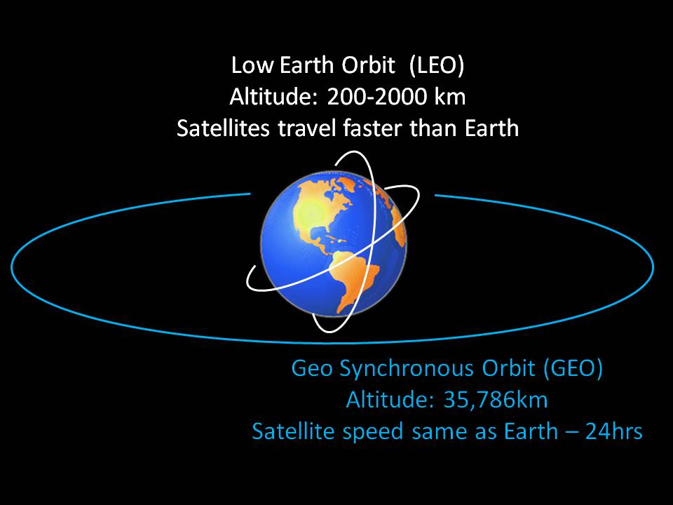
Low-Earth and High-Earth Orbits
Satellites orbit Earth at various altitudes, each serving specific functions. The two most relevant for climate science are “Low-Earth orbits” and “High-Earth orbits.”
Low-earth orbits, which range from approximately 160 to 2,000 kilometers above Earth's surface, are critical for various applications, including Google Earth imagery. For climate observations, many of these satellites follow "polar" orbits, circling over both the north and south poles multiple times daily -- see the figure below for an idea. In fact, because they track over these high-latitude regions, we generally call these satellites "Polar Orbiting Satellites." These satellites complete an impressive 14 orbits daily while Earth rotates beneath them. Their orbits are consistent, forming a stable "highway" in space, allowing them to capture images of different locations on Earth as our planet continues its constant rotation beneath their path.
While polar orbiting satellites in low-Earth orbits are vital for capturing detailed global snapshots, high-Earth orbits offer a different perspective. Satellites in high-Earth orbits, often referred to as "geostationary satellites," remain fixed over a single point on the equator, providing continuous monitoring of specific regions. This contrast between low-Earth and high-Earth orbits is key to understanding their complementary roles in climate observation!
Polar Orbiting Satellites
So, polar orbiters get a worldly view, but not all at once! Like making back-and-forth passes while mowing the lawn, these low-flying satellites methodically scan the Earth in swaths about 2600 kilometers (1600 miles) wide, covering the entire globe twice every 24 hours. Each pass collects a narrow strip of data as the satellite moves along its orbit, building a complete picture of the Earth's surface over time. The appearance of a narrow swath against a data-void, dark background on a satellite image is a dead giveaway that it came from a polar orbiter. This characteristic pattern is a direct result of the satellite's polar orbit, which allows it to capture data from pole to pole as the Earth rotates beneath it. For example, see this animation below. Just like mowing a lawn, the satellite continuously orbits over the top and bottom of the planet, taking row after row of pictures with each pass! As it progresses, the satellite methodically pieces together a comprehensive view of the Earth's surface, ensuring that every part of the planet is eventually imaged, albeit not simultaneously.
Video: Polar Orbiting: NOAA-17 Satellite Coverage (0:30) (No Audio)
Video of how the NOAA-17 satellite takes images of the entire planet. The Earth is "frozen" in space here, but in reality is continually rotating, which is why the satellite takes different pictures of the Earth's surface throughout the day.
Satellites allow scientists to observe the Earth from above the atmosphere. The National Oceanic and Atmospheric Administration, NOAA, has several different types of satellites, including geostationary and polar orbiting satellites. These datasets show the path of Polar-orbiting Operational Environmental Satellites, or POES for short. NOAA has two POES in operation currently, a morning and afternoon satellite. The morning satellite crosses the equator on the sun-light side of the Earth in the morning, and the afternoon satellite crosses in the afternoon. Both satellites orbit the Earth 14.1 times per day.
There are two datasets that show the NOAA POES, which are NOAA-17 and NOAA-18. This dataset follows the path of NOAA-17, the morning satellite, and displays the IR data that the satellite collects over a 13-hour period on February 14, 2007. The IR data is overlaid on top of the NASA blue marble image. The satellite is able to provide full coverage of the Earth in less than 13 hours. POES satellites are about 510 miles above the Earth's surface and collect a swath of data that is 1740 miles wide. The other dataset, Sunsynchronous Satellite, follows NOAA-18 and shows the path of the satellite along with the day/night terminator for one day on December 22, 2007. NOAA-18 is the afternoon satellite, which crosses the equator in the afternoon. The satellite parallels the nighttime side of the terminator. Each orbit for these satellites only takes 102 minutes. They are able to orbit the Earth so quickly because they are traveling almost 17,000 mph. If Science On the Sphere were the actual size of the Earth, the height of the POES orbit would be 4.5 inches above the surface.
So these satellites sound great – global coverage through their continual orbits. The biggest downside to polar-orbiting satellites is their lack of temporal resolution and persistence. Despite their frequent passes over specific areas, polar orbiters do not capture continuous, real-time data for a given location. Similarly, since polar orbits do not maintain a fixed position relative to the Earth's surface, they cannot continuously monitor specific regions, which limits their ability to capture long-term trends in specific areas. But scientists do have a tool to address that challenge!
Geostationary Orbit Satellites
This weakness isn’t a problem for “high-Earth” orbits, however. In high-Earth orbit, at an altitude of approximately 35,786 kilometers (22,236 miles) above the Earth's surface, satellites have an orbital velocity that harmonizes precisely with Earth's rotation, creating the illusion of "hovering" over a fixed point on the planet's surface. These satellites, known as geostationary satellites, complete one orbit every 24 hours, aligning perfectly with Earth's rotational period. They remain stationary relative to a specific point on the equator, hence the term "geostationary." This unique characteristic allows them to continuously observe the same geographical area without interruption, making them invaluable for real-time monitoring of weather systems, atmospheric conditions, and other dynamic processes over extended durations. Their ability to provide continuous data streams is particularly advantageous for tracking the development of events like hurricanes or monsoons as they unfold.
However, geostationary satellites come with their own set of limitations. Their stationary position above the equator restricts their view of high-latitude regions, where coverage diminishes and detail becomes less reliable. As they are centered over the equator, observations of clouds, weather patterns, and other phenomena in high-latitude areas become increasingly distorted as the angle of observation grows steeper, rendering geostationary satellites essentially ineffective for monitoring regions poleward of approximately 70 degrees latitude. Additionally, their primary drawback is the lack of global coverage, which contrasts with the comprehensive reach of polar orbiters that scan the entire Earth. While geostationary satellites excel at providing continuous, localized data, they rely on the complementary global sweep of polar orbiters to complete the full picture of Earth's dynamic climate system.