Lesson 3. Sizing up the Synoptic Scale
Lesson 3. Sizing up the Synoptic ScaleMotivate...
In the previous lesson, we covered many tools that mesoscale forecasters have at their disposal, but I saved the discussion of perhaps the most important tool -- an understanding of the big-picture weather pattern -- for its own lesson. Indeed, mesoscale forecasters must first study the big picture at the surface and aloft in order to make sound forecasts for mesoscale weather. In this lesson, we'll build on the fundamental concepts you learned in your previous studies so that you can better assess the synoptic-scale weather pattern and its potential impact on mesoscale weather.
For any outbreak of severe weather, it's the primary responsibility of the Storm Prediction Center to alert local forecasters and officials. Long before issuing individual severe-thunderstorm or tornado watch boxes, SPC regularly issues "Convective Outlooks(opens in a new window)" that highlight areas where thunderstorms and severe weather may pose risks. For example, take a look at the Day 1 Convective Outlook issued at 13Z on December 23, 2015, which covers the time period from 13Z on December 23, through 12Z on December 24.

For the period from 13Z on December 23 through 12Z on December 24, the forecasters at SPC had highlighted portions of the Lower Mississippi Valley as having a "moderate" risk for severe weather (a four on a scale from one to five). Surrounding this region of "moderate" risk were areas of "enhanced" risk, slight risk and "marginal" risk. What do these categories mean? For the formal definitions, I suggest you go straight to the source -- SPC's convective outlook descriptions(opens in a new window), for a better understanding of the risk categories (marginal, slight, enhanced, moderate, and high). For the record, these outlooks also outline regions having at least a 10 percent chance of "non-severe" thunderstorms(opens in a new window).
The SPC Day 1 Convective Outlook is issued several times a day. In addition to these "categorical" outlooks, SPC also issues probabilistic outlooks for large hail, damaging winds, and tornadoes (here are the outlooks for large hail(opens in a new window), damaging winds(opens in a new window), and tornadoes(opens in a new window) from December 23, 2015).
SPC's forecast for December 23 was very good, as you can tell from this overlay of severe weather reports on the 13Z Day 1 Convective Outlook(opens in a new window). How were forecasters at SPC able to highlight areas where severe weather would likely occur hours or days before thunderstorms actually formed? In this particular case, SPC began highlighting December 23 as a day with possible severe weather as early as December 20 (check out the Day 4 Convective outlook from December 20(opens in a new window)). The answer to this question is simple: forecasters thoroughly analyzed the "big picture" (synoptic-scale weather pattern) in order to identify areas where severe thunderstorms could be favored.
For a better understanding of what I mean, consider the fact that each convective outlook comes with a discussion that elaborates on the scientific rationale for predicting severe thunderstorms (here's the discussion for December 23, 2015(opens in a new window)). While some of the discussion may be undecipherable to you right now, notice that most of the content of this discussion focuses on the synoptic-scale weather pattern. Indeed, the discussion references a long-wave trough, shortwave trough, surface low-pressure system, a cold front, a stationary front, and a warm front. Those are all features you learned about in your previous studies! Tracking these features, along with an understanding of how they can impact mesoscale weather, were the keys to a successful convective outlook.
The discussion also mentions vertical wind shear and something called "CAPE," which we really haven't discussed in detail yet. These are key variables for mesoscale forecasters, and we'll tackle them early in this lesson so that you can understand how they're tied to the synoptic-scale weather pattern. From there, we'll take a tour of the troposphere (from the surface to 300 mb), reviewing some key materials from your previous studies, and discussing how weather features throughout the troposphere impact forecasts for thunderstorms.
The bottom line for Lesson 3 is that you can't become a good mesoscale forecaster until you know how to competently assess the big picture and to use the background synoptic-scale pattern to identify regions at risk for severe thunderstorms. Let's get started!
Assessing Strong Updrafts
Assessing Strong UpdraftsPrioritize...
Upon completion of this page, you should be able to define Convective Available Potential Energy (CAPE) and Convective Inhibition (CIN), as well as interpret their values. You should also be able to define the level of free convection (LFC), equilibrium level (EL).
Read...
From a weather forecaster's perspective, predicting thunderstorms and severe weather is always challenging (for a variety of reasons that we'll gradually uncover in this course). Seasoned forecasters develop their own forecasting routines and favorite tools that help to approach the problem in the most consistent way possible. In time, you'll develop your own specific approach and favorite tools for forecasting thunderstorms, but your routine should certainly include:
- getting a firm handle on the big picture (synoptic-scale weather pattern) at the surface and aloft
- getting a sense for overall instability and the potential for strong thunderstorm updrafts
- assessing the magnitude and role of vertical wind shear
While these items are listed as separate bullet points, the reality is that they're all intertwined. Aspects of the big picture impact the potential for strong updrafts as well as the magnitude and role of vertical wind shear, all of which are crucial pieces of any forecast for thunderstorms. In order to see how the big picture impacts the potential for strong updrafts and the magnitude of vertical shear (one of the overarching goals of this lesson), we have to cover a few basics first.
We'll start by covering how forecasters assess the potential for strong updrafts, and doing so requires tackling a few definitions. This discussion requires a good basic knowledge of skew-T diagrams and associated concepts, which you've studied previously. If you're rusty on these topics, I strongly recommend that you spend some time reviewing skew-T basics from Lesson 6 of METEO 101 (opens in a new window) (login required). The basics that you learned previously about how to read information and move parcels on skew-Ts will be absolutely critical in this discussion and our deeper look at skew-Ts later on, so don't skimp on any review time you might need!
With that caveat out of the way, let's start with a few definitions.
The Level of Free Convection
Recall from your previous studies that the lifting condensation level (LCL) is the level where net condensation begins in a lifted parcel. If the parcel continues to rise above the LCL (there's no guarantee it will do so), it now cools at a reduced rate -- the moist adiabatic lapse rate -- marked by the thin blue curve in the image below. If something keeps forcing the parcel to rise (lifting from low-level convergence is one possibility), eventually, the parcel reaches an altitude where its temperature equals the temperature of the environment. Assuming the air parcel rises slightly above this altitude, it becomes positively buoyant, and accelerates upward, setting the stage for deep, moist convection. In light of this convective scenario, meteorologists refer to the altitude where the air parcel first becomes positively buoyant above the LCL as the Level of Free Convection (LFC). In this context, the adjective, "free", means that the positively buoyant parcel will rise freely through a deep layer of the troposphere. No further lifting by an external force is required.

You may be asking yourself, "is there always an LFC?" The answer is a resounding, "no." For example, take a look at this sounding from Pittsburgh, Pennsylvania at 12Z on January 6, 2016(opens in a new window). A couple of things should jump out at you immediately: First, the lower troposphere is overwhelmingly stable and dry. It was warmer at 700 mb than it was at the surface at this time! Could a parcel lifted from the surface ever become positively buoyant (warmer than its environment) through a deep layer? Absolutely not! Check out this annotated sounding showing the path a parcel would take(opens in a new window) from the surface to its LCL (not far above the surface), and then lifted moist adiabatically. The parcel is always to the left of the temperature sounding, so it's colder. In other words, even with Herculean lifting, a parcel will never become positively buoyant. It has no LFC.
Even though this particular example came from a location in a cold, dry, Arctic air mass in the winter, the environment may not have an LFC at any time of year -- even in summer, when it's warm and humid. The presence of an LFC (or lack thereof) and its altitude depend largely on lapse rates and low-level temperatures and dew points (we'll explore these issues more shortly).
Equilibrium Level and CAPE
Once a parcel becomes positively buoyant above its LFC (assuming an LFC exists and the parcel makes it to that level), where does the positive buoyancy stop? The answer is called the "equilibrium level." Formally, the Equilibrium Level (EL) is the altitude above the Level of Free Convection where the temperature of a positively buoyant parcel again equals the temperature of its environment (the EL often occurs near the tropopause).
With the LFC and EL safely tucked under our learning belts, we're ready to assess the potential for strong updrafts. On skew-Ts (plotted from radiosonde measurements or model forecasts), CAPE, which stands for Convective Available Potential Energy, is simply the area between the temperature sounding and the local moist adiabat that a lifted air parcel follows between the Level of Free Convection (LFC) and the Equilibrium Level (EL). The positive area on the idealized skew-T near the top of this page(opens in a new window) (shaded in green) represents CAPE. Of course, CAPE is zero whenever there isn't any surface-based LFC (it's way too stable for air parcels lifted from the ground to become positively buoyant).
So, what does CAPE mean in a practical sense? Let's start with the idea of "Potential Energy". Quite simply, the word "Potential" refers to the possibility that air parcels lifted from the surface make it to the LFC. What about "Energy?" If air parcels lifted from the surface are able to reach the LFC, they become positively buoyant and accelerate upward through a relatively deep layer of the troposphere thanks to the temperature difference between a parcel and its surroundings, which paves the way for deep, moist convection. In light of this process, CAPE (positive area on a skew-T) is a proxy for the total possible amount of kinetic energy that an air parcel can gain between the LFC and the equilibrium level because of its positive buoyancy. The parcel's positive buoyancy is determined by the size of the temperature difference between a parcel and its surroundings, which governs the magnitude of the parcel's upward acceleration, a relationship which you can explore in the interactive tool below.
Interpreting and Using CAPE
Whenever you're working with CAPE, you should always be aware of the proper units. For the record, the units of CAPE are Joules (a unit of energy) per kilogram (J/kg). How can we interpret values of CAPE? In general, you should treat values of CAPE between 0 and 1000 Joules per kilogram as small. When you see CAPE values higher than 2500 Joules per kilogram, think large. But, I wouldn't get carried away with small and large values of of CAPE, because severe thunderstorms (and tornadoes) can and do occur with small values of CAPE (only a few hundred Joules per kilogram). On the other hand, sometimes environments with large values of CAPE (well over 2500 Joules per kilogram) fail to yield a single thunderstorm!
You'll often see CAPE described as "an overall measure of instability in the troposphere." But, treating CAPE this way has some problems. When CAPE is really high and thunderstorms fail to materialize (air parcels lifted from the surface never make it to the LFC), equating CAPE with instability is, at the very least, misleading because some parcels were nudged upward and didn't continue rising as they would in an unstable situation (they weren't forced up far enough to reach the LFC). Plus, the general public tends to equate instability with thunderstorms, so it's wise to avoid using instability to describe CAPE. When you see tables describing CAPE values on the Internet(opens in a new window), I wouldn't put much stock in them.
So how should you think about CAPE? I like to treat CAPE as a measure of the potential for strong updrafts. If air parcels lifted from the surface reach the LFC in an environment with CAPE (especially moderate to high CAPE), they accelerate upward, acquiring kinetic energy and forming strong updrafts in developing thunderstorms. If air parcels don't make it to the LFC in an environment with high CAPE, there certainly was a potential for strong updrafts, but they never materialized.
The moral of this story is that there just isn't any universal way to interpret values of CAPE. While CAPE helps forecasters assess the potential for strong updrafts, specific values of CAPE do not guarantee that thunderstorm updrafts will actually form, and cannot be connected to specific updraft speeds. For more of a quantitative look at the connection between CAPE and updraft speeds, check out the materials in the Explore Further section below.
Indeed, to interpret CAPE you must take into account climatology, the season, and the prevailing weather pattern. To see what I mean, consider that values of CAPE along the West Coast are, on average, much smaller than average values over the Middle West. Moreover, CAPE is usually smaller, on average, during winter than it is during spring and early summer.
Ultimately, what determines whether or not strong updrafts will actually materialize if CAPE is present? Let me introduce "Convective Inhibition."
Convective Inhibition
Convective Inhibition (CIN) is a proxy for the amount of energy needed to lift a parcel to its LFC. So, if CIN is great, and lift rather weak, thunderstorms probably won't happen because parcels won't make it to the LFC and accelerate upward. On an idealized skew-T (see below), CIN is the area between the temperature sounding and the dry adiabat / moist adiabat followed by a lifted parcel on its way to its LFC. CIN is represented by the negative area (in red).

In the idealized skew-T above, the temperature inversion near 850 mb, and the stable layer (small lapse rates) just above it are responsible for a large chunk of the CIN (the negative area shaded in red). To give you an idea of how to interpret CIN values, keep in mind that because CIN is a "negative area," its values are negative, and the more negative the number, the greater the CIN. In general, you can rank CIN values between 0 and minus 25 Joules per kilogram as weak inhibition. CIN values between minus 25 and minus 50 Joules per kilogram typically qualify as moderate. When you see CIN values of at least minus 50 Joules per kilogram or more, think large inhibition.
As it turns out, CIN can be reduced. How's that? In short, the synoptic-scale weather pattern helps to prime local environments for deep, moist convection by reducing CIN primarily via the following three processes:
- low-level heating
- low-level moistening
- synoptic-scale lift
We'll be exploring how synoptic-scale lifting can reduce CIN throughout this lesson, but the role of low-level heating and moistening in reducing CIN are fairly intuitive. For starters, check out this interactive tool showing how low-level heating reduces CIN(opens in a new window) (pink shading indicates CIN). In a nutshell, heating of the ground and the overlying layer of air moves the lower portion of the temperature sounding toward increasing temperatures (to the right). Meanwhile, the lapse rate in the gradually deepening boundary layer trends toward dry adiabatic, reducing CIN. Also note how the LFC lowers and CAPE (positive area) increases with time in response to low-level heating.
How does low-level moistening reduce CIN? This interactive tool illustrates the consequences of low-level moistening for CIN(opens in a new window). In essence, moistening moves the lower portion of the dew-point sounding to the right toward higher dew points. Increasing moisture causes the LCL to lower because an increase in moisture means that air parcels need not rise as far to achieve net condensation. Moreover, note that the LFC also lowers and CAPE (positive area) increases. And, of course, the lapse rate in the well-mixed boundary layer remains dry adiabatic.
These first two cases should not surprise you because increasing surface temperature and dew points ultimately translates to an increase in energy that's available for deep, moist convection. But, before we move on, I want to make an important point: If you're thinking that CIN must be zero for thunderstorms to initiate, wipe this notion from your mind. It's incorrect. Some CIN usually exists when thunderstorms erupt (but its magnitude is fairly small). Overcoming existing CIN is a major theme that we'll cover throughout this lesson.
To access real-time model analyses of CAPE and CIN, SPC's Mesoscale Analysis Page(opens in a new window) provides a great resource. Under the "Thermodynamics" menu, you'll find several "varieties" of CAPE. The most basic form, that we covered on this page, is "Surface-Based" CAPE. We'll cover some of the other types later in the course (and one in the Explore Further section below).
While forecasters use CAPE as a tool to assess the potential for strong updrafts, they look at environmental lapse rates in the lower half of the troposphere to get a more direct sense for the instability that exists. Let's investigate further.
Explore Further...
CAPE and Updraft Speed
After the discussion on this page, you should understand that CAPE is related to updraft speeds. But, how are the two connected? In the interest of full disclosure, the connection is not as straightforward as you might think. In theory, the maximum updraft speed is equal to the square root of double the CAPE value. To see the mathematics behind that assertion, check out the "Chalkboard Lecture" in the slideshow below.
Updraft speeds computed by taking the square root of 2 x CAPE turn out to be too high because raindrops, hail, and other hydrometeors carry weight, which slows down the updraft. Other factors such as evaporative cooling also help to slow down the updraft (evaporative cooling makes air more dense and thus less buoyant). Operationally, the maximum speed of an updraft is about half the calculation above.
But, does this mean that if the CAPE values at two locations are approximately equal that updraft speeds will be the same? Surprisingly, the answer is "no." To see why, watch the short video below (2:39 minutes).
The "Shape" of CAPE
PRESENTER: The question we're going to explore is, if values of CAPE are approximately equal at two different locations, are the potential updraft speeds also equal? The answer is, not necessarily. To see what I mean, check out the 0Z skew-T at Norman, Oklahoma from April 5, 2010. Now in this sounding, CAPE shaded in yellow. And the CAPE value, which was calculated by computer, is 1,496 joules per kilogram.
Now compare that sounding to the one from Charleston, South Carolina at 0Z on August 6, 2010. Again, CAPE is shaded in yellow. And the CAPE on this sounding is 1,538 joules per kilogram. So that's a similar value to the Norman sounding. And they're approximately equal to within a couple percent.
But what's different about the two profiles? At Charleston, the CAPE is kind of tall and skinny, while the positive area on the Norman sounding is notably shorter and fatter. The temperature difference between the environment and an air parcel that's rising is greater on the Norman sounding. Now that has important implications. This fatter CAPE at Norman translates to stronger buoyancy at lower altitudes, and that means greater accelerations and greater upward velocities at lower altitudes.
So in general, a shorter, fatter, positive area corresponds to potentially faster updrafts at lower altitudes compared to tall, skinny, positive areas. And that assumes that CAPE and all other factors are approximately equal. Now these distinctions can impact the microphysical processes going on clouds. And there are possible implications for severe weather. One possible implication to stronger updrafts at lower altitudes is that a storm's propensity to produce hail or damaging winds might be enhanced when updrafts are stronger at lower altitudes.
Now there are some techniques that exist to try to level the playing field for tall, skinny CAPEs versus shorter, fatter CAPEs. And the Storm Prediction Center has plots of normalized CAPE. And normalized CAPE is CAPE divided by the depth of the buoyancy layer. So smaller values of normalized CAPE, around 0.1 or less, suggest tall, skinny CAPE. Meanwhile, larger values, 0.3 to 0.4 or even higher, indicate shorter, fatter CAPE, and potentially faster vertical accelerations in the lower troposphere.
So although normalized CAPE does have forecasting utility, really the best practice is to actually look at skew-T and get a real sense for the vertical structure of the troposphere.
Lapse Rates
Lapse RatesPrioritize...
When you've completed this page, you should be able to define conditional instability, as well as assess the stability of a layer (or trends in stability) from its lapse rate (or trends in lapse rate).
Read...
In the previous section, you learned that CAPE helps forecasters to assess the potential for strong updrafts, but doesn't directly tell us about atmospheric stability. If you want to assess the stability of a specific layer of the atmosphere, the key is lapse rates. Therefore, forecasters use lapse rates in concert with CAPE to assess stability and the potential for strong updrafts.
In your previous studies, you learned that the lapse rate is the change in temperature with altitude in any given layer of air. As a general rule, the greater the decrease in temperature with height, the greater the likelihood for convective overturning and the development of thunderstorm updrafts. So, how do we assess how "large" or "small" environmental lapse rates are in a given situation? Start by keeping in mind some key "benchmark" lapse rates that will help you as you assess the stability of specific atmospheric layers:
- the dry-adiabatic lapse rate: 9.8 degrees Celsius per kilometer (you can use about 10 degrees Celsius per kilometer as a proxy)
- the moist-adiabatic lapse rate: roughly 6 degrees Celsius per kilometer, but recall that this lapse rate is not constant -- 6 degrees Celsius per kilometer simply serves as a ballpark reference for the lower troposphere
In light of the introduction to CAPE in the previous section, it should come as no surprise that the environmental lapse rate (which you can assess via 12Z or 00Z temperature soundings or by model forecasts) plays a key role in the calculation of CAPE. So when lapse rates are steep, (large decreases in temperature with altitude), CAPE tends to be high. CAPE, however, can also be relatively high when lapse rates are rather modest but the lower troposphere is moist. Indeed, the presence of low-level moisture tends to lower the LFC and increase CAPE accordingly.
Let's take a look at CAPE and lapse rates on a sounding to see what we can tell about the potential for strong updrafts and the stability of individual layers. For starters, check out the skew-T from Miami, Florida, at 00Z on July 9, 2010 (below)

On this skew-T, the vertical profiles of temperature and dew point are the red and green soundings, respectively. The blue curve represents the path of an air parcel lifted from the surface. At the time, there was very little CIN and a CAPE value of 1,649 Joules per kilogram. Note that the temperature profile is dry adiabatic in the boundary layer (from the surface to about 930 mb), which represents a steep lapse rate. But, above that, the temperature profile is actually rather stable in most layers. One exception is the layer between roughly 930 mb and 800 mb, where the temperature profile is conditionally unstable, meaning that the environmental lapse rate is less than the dry adiabatic lapse rate but greater than the moist adiabatic lapse rate(opens in a new window).
If you nudge a test parcel originating in this layer upward, its stability depends on whether or not the parcel is saturated (that's the "condition" of the instability). If the parcel is initially saturated and nudged upward from its initial position, it will accelerate away from its initial position because the parcel cools at the moist adiabatic lapse rate (keeping it warmer than the environment). However, if the parcel is unsaturated, it will quickly become cooler than its surroundings (and negatively buoyant) if nudged upward, because it cools at the dry adiabatic lapse rate. An unsaturated parcel would sink back to its initial position.
With the exception of another notable conditionally unstable layer from roughly 600 mb to 520 mb, most other layers above 800 mb are rather stable (small lapse rates). Parcels originating in those layers will sink back to their original positions if nudged upward. So, where does all the CAPE (and potential for strong updrafts) come from? High surface temperatures (and steep lapse rates in the boundary layer), and high dew points in the boundary layer. If you look at the vertical profile of dew points in the boundary layer over Miami at this time, they varied from the upper 60s to the lower 70s degrees Fahrenheit (roughly 20 to 23 degrees Celsius). Yes, the boundary layer was rather moist. As a result, the LFC lay at a relatively low altitude, paving the way for a "tall, skinny" area of CAPE. The fact that lapse rates were relatively small above 800 mb made for relatively small differences a rising parcel's temperature and its surroundings, and a "skinny" positive area. In case you're curious, there were no thunderstorms around Miami at this time, despite the presence of CAPE and the very small amount of CIN present. For more discussion about why, check out the Explore Further section below.
CAPE resulting from steep lapse rates, creates stronger vertical accelerations and updraft velocities, and tends to catch forecasters' attention. Therefore, forecasters find it convenient to have options that allow them to take "shortcuts" and narrow their focus to areas where relatively high CAPE is primarily a result of steep lapse rates (where deep, moist convection tends to be more active, assuming, of course, that there's also ample moisture). As it turns out, so can you!
Consider the lapse rate products available on the SPC Mesoanalysis Page(opens in a new window) (in the "Thermodynamics" menu). Although the depths of thunderstorms (cloud base to cloud top) vary, forecasters typically look at low-level lapse rates (between the surface and three kilometers), and/or mid-level lapse rates (700-500 mb, or roughly 3-6 kilometers), depending on the local environment in which storms are expected to develop. Below is an example of an analysis of lapse rates, expressed in degrees Celsius per kilometer, in the 700-mb to 500-mb layer at 20Z on July 3, 2010.
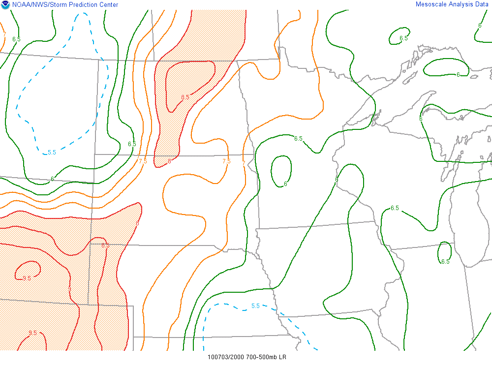
In the image above, note the tongue of very steep mid-level lapse rates extending northeastward across western Nebraska and southwest South Dakota (areas with lapse rates greater than 8 degrees Celsius per kilometer are shaded). These lapse rates were technically conditionally unstable since they were greater than the moist adiabatic lapse rate, but weren't quite as great as the dry adiabatic lapse rate. Still, in the real atmosphere, environmental lapse rates rarely exceed the dry adiabatic lapse rate, so you can consider lapse rates approaching 8 and 9 degrees Celsius per kilometer, as "steep" (generally favorable for deep, moist convection).
Low-level lapse rates (between the ground and three kilometers) were pretty steep over western Nebraska and southwest South Dakota, too (20Z low-level lapse rates(opens in a new window)). In turn, CAPE was also relatively high (20Z analysis of CAPE and CIN(opens in a new window)), and SBCIN (surface-based CIN) was vanishing in response to surface heating (note surface temperatures well into the 80s on the 20Z analysis of surface temperatures(opens in a new window)).
In this case, thunderstorms did erupt thanks to convergence associated with an approaching cold front (21Z surface analysis(opens in a new window)) and some rather weak upslope flow(opens in a new window) (topographic map(opens in a new window)). Both of these lifting mechanisms helped parcels overcome the remaining CIN to reach the LFC, setting the stage for thunderstorms (23Z radar reflectivity(opens in a new window)).
The moral of the story is that you should routinely look at lapse rates (both low- and mid-level) in situations where deep, moist convection might develop. And, as you'll see in the coming sections, analyzing the synoptic-scale pattern helps weather forecasters understand lapse-rate tendency (change in lapse rate over time), which helps forecasters anticipate potential changes to CAPE and CIN.
After identifying regions with relatively high CAPE and steep lapse rates and assessing whether synoptic-scale lift (or mesoscale lift) can get air parcels to the LFC, forecasters turn to the issue of vertical wind shear, which helps me to determine the mode of deep, moist convection. Let's investigate.
Explore Further...
Recall that in the example from Miami, Florida above, there was a tall, skinny area of CAPE, with very little CIN. Yet, no thunderstorms formed. To confirm, check out the meteogram from Miami (below) from 02Z on July 8, 2010 through 03Z on July 9.

If you revisit the Miami skew-T from earlier on the page(opens in a new window), note that there was a relatively large portion of the troposphere that was not even close to saturation (temperature and dew-point soundings were pretty far apart, indicating low relative humidity). If you're speculating that so much dry air (dew points as low as minus 50 degrees Celsius near 500 mb) would have a negative impact on growing cumulus clouds, you're definitely on the right track.
You might be thinking, what would stop a moist parcel, after reaching the LFC, from staying positively buoyant through a deep layer? Technically, nothing. But, it's not realistic. According to parcel theory (what you learned in your previous studies, and is pervasive throughout meteorology) we don't allow air parcels to interact with their environment when we move them up and down on skew-T diagrams. Parcels in the real atmosphere, however, DO interact with their environments, which means parcel theory has some limitations. We'll discuss some adjustments to classic parcel theory later in the course.
For now, to understand why dry air in the middle troposphere can inhibit growing cumulus clouds, think of the updraft in a growing cumulus cloud as a plume of rising air that does interact with its environment. In the environment depicted on the Miami skew-T, dry air in the middle troposphere mixed into the tops of any growing cumulus clouds (a process called "entrainment"). The entrainment of unsaturated air into the tops of growing cumulus clouds typically weakens updrafts because it promotes evaporation and cooling (evaporational cooling reduces the positive buoyancy associated with the updraft). Thinking about it another way, the evaporation of cloud drops tends to offset the primary source for thunderstorm strength: the release of latent heat of condensation (since it's the release of latent heat that slows the cooling of rising air parcels, keeping them warmer than their surroundings).
Vertical Wind Shear
Vertical Wind ShearPrioritize...
Upon completion of this page, you should be able to define vertical wind shear, and discuss its role in convective forecasting. You should also be able to define "bulk shear," and the threshold at which 0-6 kilometer bulk shear is considered strong, increasing the chances of sustained thunderstorm updrafts (including supercells).
Read...
Of all the concepts you'll learn in this course, none has more forecasting utility than the following principle: Vertical wind shear governs the mode (type) of thunderstorms. Thus, vertical wind shear is of huge interest to mesoscale forecasters. After assessing the background synoptic-scale pattern and evaluating CAPE (and CIN) in order to identify regions where thunderstorms will likely be initiated, forecasters routinely turn their attention to vertical wind shear to help them assess what potential types of thunderstorms will develop, and how long-lived they might be. We haven't covered any details yet, but you've already heard me mention that long-lived, rotating updrafts usually form in environments with relatively strong vertical wind shear.
To get an understanding of the importance of vertical wind shear, we need to first learn how to determine vertical wind shear over a fixed point. Then I'll introduce and discuss Rapid Refresh analyses of vertical wind shear between the ground and an altitude of six kilometers, which, as you will also learn in this section, is a crucial layer that forecasters consider whenever supercells are possible.
For starters, as I've mentioned, vertical wind shear is a change in wind speed and/or wind direction with altitude. To get your quantitative bearings, check out this vertical profile of winds, showing an environment with relatively strong vertical wind shear(opens in a new window) between the ground and six kilometers. Note that wind direction doesn't change very much in the layer, but the dramatic increase in wind speed with height should be obvious. Now, compare the example with strong vertical shear to a vertical profile of winds(opens in a new window) with weak shear.
So, how do we formally calculate vertical wind shear? Given that the wind is a vector (it has both direction and magnitude), we can calculate vertical wind shear in any given layer of air by taking the wind vector at the top of the layer minus the wind vector at the bottom of the layer (vector subtraction).
Right off the bat, you should see that vertical wind shear is also a vector (the difference between two vectors is a vector). As a vector, vertical wind shear has both magnitude and direction. I realize that many of you aren't accustomed to working with vectors, but we can simplify the vector subtraction by plotting the wind vectors as shown below.

On the graph above (called a "polar coordinate" graph), the circles represent wind speed expressed in knots and the interval between successive circles is 10 knots. The horizontal and vertical axes serve as references for a wind compass(opens in a new window) so that we can also take wind direction into account.
To start, let's assume that we want to calculate the vertical wind shear vector in a layer of air where the wind at the top of the layer blows from the west-northwest (300 degrees) at 40 knots, while the wind at the bottom of the layer blows from the west-southwest (250 degrees) at 10 knots. To plot the wind vector at the top of the layer, I estimated 300 degrees on the wind compass and judiciously placed a small dot (not shown) on the fourth concentric circle from the origin. Then I drew the vector corresponding to the wind at the top of the layer (bluish) from the origin to the dot. Now for the wind at the bottom of the layer. I estimated 250 degrees on the wind compass and placed a dot (not shown) on the innermost circle and drew the vector (in green).
To subtract the lower wind vector from the upper wind vector, simply draw a vector from the arrowhead of the lower wind vector to the arrowhead of the upper wind vector. Yes, the black vector represents the vertical wind shear vector in the layer. It has magnitude (35 knots) and direction (314 degrees). I'll spare you the trigonometry of how I arrived at that specific numerical answer, but you can at least see how the process works graphically. I also recommend checking out this interactive tool that automatically calculates the vertical wind shear vector(opens in a new window) for any given layer of air. Exploring this tool will allow you get comfortable with treating vertical wind shear as a vector.
Now that you have an idea of how vertical wind shear is calculated, the big question becomes, "What layer (or layers) of the troposphere is (are) important for predicting whether there will be long-lived, rotating updrafts?"
Cloud-Layer Shear
The answer to the question I just posed is vertical wind shear in the "cloud layer" (the layer encompassing the convective clouds that comprise thunderstorms). For the record, cloud-layer shear is simply the magnitude of the vector difference between the wind at cloud base and the wind at the top of the storm. A couple of aspects of shear within the cloud layer are critically important for thunderstorm forecasting. First, updrafts can be persistent (last longer) when deep-layer wind shear is sufficiently strong. Second, updrafts can begin to rotate (supercells can form) when low-level wind shear is sufficiently strong.
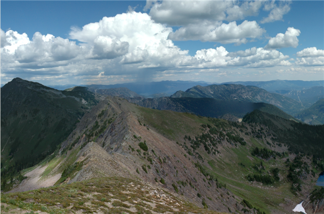
However, the altitudes of cloud bases and cloud tops (particularly the latter) vary from place to place and time to time. For example, the photograph below shows a high-based thunderstorm, which gets its name from a relatively high LCL. Not surprisingly, the depths of storms also vary with location (higher tops in southern Florida compared to southern Canada, for example) and with season (higher tops in summer, for example). Storm depths vary with the synoptic-scale environment as well (no surprise there, either). So, performing an exact cloud-layer shear calculation is quite challenging.
Given the challenges that exist in calculating cloud-layer shear exactly, how do forecasters approach the issue of vertical wind shear when it comes to forecasting deep, moist convection? In order to compare cases from one day to another, or from location to location, forecasters rely on the vertical wind shear between the ground and six kilometers (usually abbreviated 0-6 km shear or sfc-6 km shear) as a standard tool. Of course, 0-6km shear isn't really the same thing as cloud-layer shear, but forecasters often use it as a proxy when thunderstorm updrafts will be surface based (you'll learn later in the lesson that some thunderstorm updrafts don't actually originate at the surface).
Why 0-6 kilometers? Good question! As it turns out, model simulations conducted by the Weisman and Klemp in the 1980s helped to identify the layer between the ground and an altitude near six kilometers as pivotal for predicting thunderstorm type. If you're interested, here's Weisman and Klemp's classic 1982 paper(opens in a new window). Although much of this paper is beyond what we've covered so far, by the end of the course, you'll actually be able to comprehend much of Weisman and Klemp's findings! Weisman and Klemp's simulations indicated that thunderstorms tended to be short-lived whenever model environments lacked deep vertical wind shear (strong shear didn't extend to altitudes near six kilometers). Later empirical research confirmed that vertical shear needs to be relatively strong through the lowest five or six kilometers of the troposphere in order for supercells to form.
With that background out of the way, let's take a quick look at an example. On June 5, 2009, the VORTEX2(opens in a new window) team intercepted a supercell tornado in Goshen County in southeast Wyoming(opens in a new window) (YouTube video(opens in a new window)). At 22Z, the magnitude of the roughly westerly vertical wind shear between the ground and six kilometers was approximately 50 knots (see 22Z analysis below from the national archive at the Storm Prediction Center(opens in a new window) -- images of sfc-6 km Shear are listed as "shr6"). In real time, you can access regional fields of 0-6 km shear on SPC's Mesoanalysis page(opens in a new window) (in the "Wind Shear" menu).

The 50-knot shear magnitude between the surface and six kilometers over Wyoming is a "bulk" shear value, meaning that it's the overall shear between the top and bottom of the layer. Such "bulk" shear calculations do not account for "internal" changes in wind speed and / or direction that occur at intermediate altitudes between the ground and six kilometers. According to the Storm Prediction Center, the threshold of sfc-6 km shear that favors sustained, persistent updrafts (and possibly supercells) is roughly 35-40 knots, so the shear over southeast Wyoming at this time was plenty strong.
However, you shouldn't think of this 35-40 knot threshold for sustained updrafts and supercells as a "hard" threshold. Indeed, persistent updrafts and supercells can sometimes happen with lower magnitudes of 0-6 km shear. Given the right environmental conditions, some experienced forecasters start to consider the possibility of supercells when 0-6 km shear reaches about 20 knots, especially when there was a fairly dramatic change in wind direction between the ground and six kilometers (from the southeast near the surface to westerly or even northwesterly at six kilometers, for example). You will learn later that a dramatic turning of winds (change in wind direction) in the lower troposphere is an important ingredient that favors rotating updrafts.
There's no doubt that a magnitude of 20 knots for 0-6 km shear is way, way below the thresholds you'll see quoted by most sources, but at least thinking about the possibility of supercells in such environments helps to reduce the element of surprise from rare, "unexpected" supercells. The bottom line is that the probability of sustained, rotating updrafts increases markedly near the 35-40 knots quoted by SPC. Therefore, I strongly recommend that you use this more-accepted threshold (35-40 knots) as we move through the rest of the course.
The upshot of this discussion is a basic rule you can take with you: All other factors being equal, the greater the 0-6 km shear, the greater the probability for sustained, rotating storms, especially when there's a dramatic change in wind direction from the ground to six kilometers.
Of course, 0-6 km wind shear doesn't stay "static" in time. It's constantly evolving depending on the synoptic-scale pattern, and those changes are a big forecasting consideration. Now that we've established the importance of variables like CAPE/CIN, environmental lapse rates, and 0-6 km shear, we'll shift gears to look at how the synoptic-scale pattern impacts these fields. Before we move on, however, keep in mind that vertical wind shear isn't just an issue in thunderstorm forecasting. Indeed, interested students may want to check out the Explore Further section below to see how vertical wind shear played a role in a national tragedy.
Explore Further...
Vertical wind shear is critical in thunderstorm forecasting, but it has many other important forecasting applications, as well. In an extreme example of the importance of vertical wind shear, we could say that strong vertical wind shear contributed to a national tragedy. On January 28, 1986, the Space Shuttle Challenger(opens in a new window) launched from Kennedy Space Center. Below is the 12Z sounding from nearby Cape Canaveral, Florida from the morning of the launch. Note the very cold surface conditions (temperatures below 0 degrees Celsius, or 32 degrees Fahrenheit), as well as the significant vertical wind shear present (particularly changes in wind speed).

The cold conditions and strong vertical wind shear both conspired with structural deficiencies to cause the shuttle to disintegrate 73 seconds after launch. All seven crew members were killed as millions watched on television. In 2021, Dr. Jon Nese produced the feature for the Penn State Meteorology Department's Weather World(opens in a new window) program, which described weather's impact on the disaster (below) (3:28 minutes).
WxYz January 27, 2021
[Dr. Jon Nese] Weather has played a pivotal role in many significant events in history, some of them disastrous.
One such incident, 35 years ago tomorrow, vividly sticks with me. I remember exactly where I was when it happened—an event that shattered the stability of the manned U.S. space shuttle program.
The first orbital flight of the shuttle was in April 1981, when Columbia spent a little more than two days in orbit. By mid-January of 1986, another 23 missions had flown using Columbia and three other shuttles: Atlantis, Challenger, and Discovery. Weather had delayed many launches and landings in those years, but there were no catastrophic weather-related problems.
One pesky design issue had dogged many of those early launches. To provide thrust, the shuttle used two solid rocket boosters connected to a large external fuel tank. Each booster had six sections, and some of the joints between sections were sealed by pairs of synthetic rubber gaskets called O-rings. These helped contain the hot, high-pressure gases produced when the fuel burned. These O-rings had leaked during 15 shuttle flights prior to January 1986.
Despite redesign efforts to address the problem, in addition, low temperatures made the rubber O-rings less elastic and thus less likely to properly seal the joints. The tenth flight of shuttle Challenger was originally set for January 22, 1986. It was the highly publicized "first teacher in space" mission, but the launch was delayed until the 28th. That morning was unusually cold, with temperatures in the low 20s at Cape Canaveral. Shuttle launches were prohibited at temperatures below 31 °F, so the launch was pushed back to late morning to allow the atmosphere to warm.
But the unusual chill had already compromised the O-rings on one of the rocket boosters. Analysis of images after the accident showed gray smoke leaking from the booster in the seconds after ignition. At first, the damaged joint was temporarily sealed by residue from some of the burned fuel. But about 30 seconds after launch, the shuttle entered a zone of large wind shear, with speeds increasing from about 70 miles per hour at 20,000 feet to more than 140 miles per hour at 45,000 feet.
In response, the automated steering system made more adjustments than on any previous flight to counter the changing aerodynamic forces on the vehicle. Were it not for this extra maneuvering, the temporary seal on the booster joint might have held. But instead, hot gas began to leak again and eventually flames burned through the strut connecting the booster to the external fuel tank. This started a series of catastrophic events that led to the breakup of the orbiter 73 seconds into flight and the loss of the crew of seven.
The Challenger disaster resulted in a 32-month hiatus in the space shuttle program. Once it resumed in September 1988, 110 more missions flew, including one other non-weather-related catastrophic failure—Columbia in 2003. The final space shuttle mission was nearly 10 years ago, in July 2011.
Stay tuned—our extended forecast is next.
The Big Picture at 500 mb
The Big Picture at 500 mbPrioritize...
When you've finished this page, you should be able to describe the impacts of important 500-mb features, such as shortwave troughs and mid-level jets on CAPE, CIN, and vertical wind shear. More specifically, you should be able to describe how shortwave troughs "prime the atmosphere" for deep, moist convection by altering lapse rates (which has implications for CAPE and CIN).
Read...
When forecasters assess the "big picture" in making a forecast, it's important to assess conditions throughout the entire troposphere. Therefore, forecasters frequently look at surface conditions (and forecasts), as well as those at 850 mb, 700 mb, 500 mb, and either 300 mb or 250 mb. Seasoned forecasters know what signs to look for at each of these levels as they relate to the possibility of deep, moist convection developing.
To get started, we're going to look at 500 mb, a level that you examined extensively in your previous studies. You should be very familiar with the features we'll be focusing on (namely, shortwave troughs), but now we're going to tie some of your past knowledge in with how these features can effect the environment for deep, moist convection. As you are about to see, shortwave troughs have important impacts on vertical motion and lapse rates that can make the environment more favorable for deep, moist convection.
Impacts of 500-mb Shortwave Troughs
For surface-based thunderstorms, synoptic-scale lift typically boils down to low-level convergence (along surface fronts and mesoscale boundaries) and upper-level divergence. Of course, there are other forms and scales of lift that can get air parcels to the LFC (orographic lift, for example). Here, however, I only want to address synoptic-scale lift in this section, and, in particular, divergence downwind (usually east or northeast) of a 500-mb trough. For starters, review this animation tracking a parcel through a shortwave trough(opens in a new window), which I hope you recall from your previous studies. The schematic below serves as a supplement for the animation. Any way you slice it, there's divergence downwind of a 500-mb shortwave trough because air parcels moving east from the base of a shortwave trough lose some of their spin (absolute vorticity decreases) by expanding their surface areas. Sound familiar? This upper-level divergence, in concert with low-level convergence, encourages upward motion, which promotes local cooling.

Of course, the animation and schematic above are highly idealized. Shortwave troughs often don't look as neat and tidy as they do in these idealized graphics. Take, for example, the 500-mb pattern shown by the 12Z run of the NAM on February 2, 2016, valid at 18Z(opens in a new window) that day. The feature that probably jumps out at you right away is the closed low and strong vort max right over the center of the country. That closed low marks the core of a longwave trough, but embedded within that longwave trough are several shortwave troughs.
A couple of those shortwave troughs are marked by the X's over northern Mexico. But, there's another shortwave trough over New Mexico that is not marked by an X. Do you see it? The very small closed contour (darker yellow shading) over Central New Mexico also marks a subtle vort max and shortwave trough(opens in a new window), even though it lacks the classic "X." The details of the positions and intensity of shortwave troughs (even subtle ones) is of great interest to mesoscale forecasters, because those details determine where (and how strong) the divergence is.
To get an idea of what I'm talking about, check out this 17Z Rapid Refresh analysis of 500-mb heights(opens in a new window) (black contours), vorticity (dashed contours and color-filled regions), and differential vorticity advection (blue contours) from February 2, 2016 (one hour before the NAM forecast prog above was valid). You can think of differential vorticity advection as a proxy for upper-level divergence. Note that the strongest divergence is located in a band from eastern Nebraska through Iowa and into Illinois, to the northeast of the strongest vort max (over Kansas). However, there are lots of other pockets of differential vorticity advection (divergence) over the Southern Plains due to the details of the vorticity field. Note that our subtle vort max over New Mexico was creating some weak divergence just to its east, as well.
On this particular date, SPC had outlined an enhanced risk of severe weather in their Day 1 Convective outlook(opens in a new window), but the greatest risk area wasn't related to the strongest divergence at 500 mb. It was farther south, in the path of those more subtle vort maxes, where periods of weaker divergence aloft would occur throughout the day as those weaker vort maxes rounded the base of the longwave trough as it crawled eastward. In other words, the severe weather threat isn't always where the strongest lifting at 500-mb is!
So, why is synoptic-scale lifting and its associated cooling pivotal to the development of deep, moist convection? It reduces (or removes) CIN! For starters, a typical vertical profile of temperature associated with the presence of CIN often shows a stable layer in the lower troposphere (on the interactive tool below, note the stable layer just above 850 mb). You may think of this stable layer as relatively warm air. To see what I mean, recall that, within a stable layer, temperature sometimes increases with increasing altitude (a temperature inversion), stays constant with increasing altitude (an isothermal layer), or decreases rather slowly with height. If you look closely at the idealized sounding, the stable layer just above 850 mb is helping to create CIN (shaded in pink).
Now, let's follow the evolution of the stable layer (a weak inversion, in this case) as a 500-mb shortwave trough approaches. Remember, there's upper-level divergence east of the 500-mb shortwave. Assuming a surface boundary also lies to the east of the 500-mb shortwave (which is a reasonable assumption), then there's also some low-level convergence to help the cause. At any rate, there's upward motion and cooling in local columns of air that extend up to 500 mb on the eastern flank of the 500-mb shortwave. To simulate this lifting and cooling, drag the shaded layer of air upward in the tool above.
Above the well-mixed boundary layer, the temperature sounding shifts to the left (the air cools aloft) in response to the upward motion associated with divergence ahead of an approaching 500-mb shortwave trough, which reduces CIN and lowers the altitude of the LFC.
What happens to CAPE when there's cooling from upward motion? To focus solely on this process, we assume that the surface temperature and dew point hold steady. The leftward shift of the temperature sounding above the boundary layer means that CAPE also increases (positive area increases). When you look at the temperature sounding at lower altitudes, note that the depth of the well-mixed boundary layer increases with time. That's because cooling (via upward motion) at the top of the boundary layer promotes local mixing so that the depth of the well-mixed layer expands.
The bottom line is that synoptic-scale lift reduces CIN, and increases CAPE. So, as a developing mesoscale forecaster, you should think of divergence east of a 500-mb shortwave trough as a way to "prime" the troposphere for deep-most convection. Indeed, a 500-mb shortwave does not really "trigger" thunderstorms. It simply makes the environment more conducive for thunderstorms to develop because it helps to reduce CIN.
Height Tendencies and Lapse Rates
Upward motion, however, isn't the only way that 500-mb shortwave troughs can make the environment more favorable for thunderstorms. In addition, falling 500-mb heights ahead of the shortwave trough tend to go along with decreasing mid-tropospheric temperatures (recall that the cores of 500-mb closed lows and shortwave troughs are mid-level pockets of relatively cold air). In other words, cooling at 500 mb usually helps to destabilize the middle troposphere. A 500-mb shortwave trough tends to cause mid-level lapse rates to increase with time (the lapse-rate tendency is positive).
As we get even closer to the core of an open 500-mb shortwave trough (or a closed low), 500-mb heights noticeably "fall" (decrease) over time as the system moves eastward, and mid-level lapse rates steepen even further. To see an example, check out the image below showing 500-mb heights (black contours) at 21Z on July 14, 2010, and the 12-hour height tendencies leading up to that time. Treating 500-mb lows and troughs as mid-level pockets of cold air, it stands to reason that 500-mb temperatures typically decrease as these cold pockets approach. Assuming there's some solar heating and / or some low-level convergence to get surface air parcels to the LFC, showers and thunderstorms can also develop closer to the core of the 500-mb low or open trough.

Note the pocket of height falls to the east of the 500-mb shortwave trough centered near the Saskatchewan / Manitoba border at 21Z. In the 12 hours leading up to 21Z, heights had been falling (and mid-level lapse rates increasing) out ahead of the trough, with the biggest height falls marked by the blue shaded region just southeast of the closed low.
The mid-level cooling and steepening lapse rates associated with 500-mb troughs acts to boost CAPE values, favoring stronger updrafts as long as parcels are able to reach the LFC. So, 500-mb troughs can prime the atmosphere for deep, moist convection through reducing CIN via synoptic-scale upward motion, and through boosting CAPE from mid-level cooling. To see all of these processes in action, check out the Case Study video below.
Mid-Level Jets
Impacts on CAPE, CIN, and lapse rates aren't all forecasters think about when they evaluate the 500-mb pattern. They also look for "mid-level jets" (zones of fast winds at 500 mb). For example, the 12Z 500-mb RUC analysis from July 14, 2010(opens in a new window) (same date as the height tendency map above) shows a 500-mb speed maximum over the Upper Middle West that shadowed the vigorous shortwave trough.
Why are mid-level jets like this one important? They tend increase the vertical wind shear in the layer from the ground to six kilometers. Remember that the 500-mb level tends to be around 5,500 meters, so when relatively fast winds exist around that level, vertical wind shear tends to increase in the layer between the surface and six kilometers. Regardless of any changes in wind direction, the fast flow in the middle troposphere that goes along with a mid-level jet means there is usually a marked increase in wind speed between the surface (where friction slows the wind speed) and the middle troposphere.
Now that you've seen how 500-mb shortwave troughs can prime the atmosphere for deep, moist convection, and mid-level jets (which sometimes exist in concert with 500-mb shortwaves), please take some time to view the Case Study below, which details how the arrival of the 500-mb shortwave trough and mid-level jet that you just saw helped to spur deep, moist convection (and severe weather) over the Upper-Mississippi Valley.
Case Study...
You've already seen a couple of examples on this page from July 14, 2010. To tie together the concepts covered on this page, and see how upward motion, the arrival of cool air in the middle troposphere, and a mid-level jet can work together to prime the atmosphere for organized deep, moist convection, check out the video below (7:12 minutes).
July 14, 2010: The Big Picture Contribution at 500 mb
PRESENTER: In their day one convective outlook for July 14th 2010, forecasters at the Storm Prediction Center highlighted sections of the upper midwest, mainly southeastern Minnesota, and much of Wisconsin, and Northeast Iowa as having a moderate risk of severe weather. Now surrounding this area of moderate risk was a larger area with a slight risk of severe weather.
So what helped SPC forecasters hone in on this general area as being at risk for severe thunderstorms? Well, the synoptic scale weather pattern, the big picture, was a big help. And in this case, an approaching 500 millibar shortwave trough was a big part of that.
If we look at the 12Z analysis of surface-based CAPE and CIN on this date, we can see that the environment at that time was not very conducive to strong updrafts in the region highlighted by SBC as having a moderate risk for severe weather. There was very very strong CIN. The dark blue shade in here means that CIN was at least 100 joules per kilogram in magnitude. And there wasn't very much CAPE there as well even though there was very high CAPE values off to the southwest over the plains.
But if we want to dial it in at a single location, you get a more specific idea of the environment, we can look at the sounding from 12z at Minneapolis. And you can see that there is a layer of CIN. It's shaded in yellow here, and it extends from about 925 millibars all the way up above 700 millibars. And the exact magnitude here is minus 329 joules per kilogram. So that's really, really strong in inhibition and it will take herculean lift to overcome that. That's just not going to happen. So the environment needs to change in order for severe weather or severe thunderstorms to develop.
And throughout the day, the environment did change and did become more favorable for thunderstorms. And in part, that's because as the day progressed, it warmed up. And warming the surface is one way we can reduce convective inhibition. But an approaching 500 millibar shortwave trough also provided a lot of help. If we look at the six hour NAM forecast for 500 millibar heights and vorticity, we can see a closed low with a strong vort max located near the Saskatchewan/Manitoba border.
But this vort max here is pretty much too far north to really create divergence in the risk area, which is farther to the southeast here over Minnesota and Wisconsin. But if you notice that trailing around the southern periphery of the trough, there is this elongated lobe of vorticity over north Dakota.
There's also some weak vort maxes over Minnesota. Those weaker vort maxes around the southern edge of the trough could create some divergence over the risk area. And that synoptic-scale upward motion over Minnesota and Wisconsin during the afternoon did help prime the atmosphere for severe thunderstorms.
Now to confirm the forecasts for upward motion anyway, here's the NAM forecast for 700 millibar heights relative humidity and omega. Now you may remember that Omega is a way to measure vertical motion. And the brown contours in this, it looks like a jumbled mess over Minnesota, that indicates negative values of omega. And those correspond to upward motion.
The values here were as much as about minus 15 microbars per second. And that's about 15 centimeters per second of upward motion. That's not very fast upward motion in the scheme of things, certainly compared to the speedy updrafts of thunderstorms. But these magnitudes of upward motion are fairly indicative of the upward motion that can be caused by the divergence ahead of approaching vort maxes.
The cooling that was induced by this upward motion helped prime the atmosphere for severe thunderstorms by reducing CIN and boosting CAPE. And by 19z, we can see that the environment had changed quite a bit. And you can see that over much of southern Minnesota, CIN had been greatly reduced and down to less than 25 joules per kilogram. So CIN was now weak and CAPE had skyrocketed over the region. There were several thousand joules per kilogram of CAPE, so there was a much greater potential for strong updrafts.
And some of that change came from the fact that there was surface warming during the day. And that helped to reduce CIN and reduce CAPE as well. But lapse rates in the middle troposphere were changing too thanks to that cooling aloft from the upward motion and from falling heights ahead of that trough.
To get a better feel for the changes in the lapse rates, we can look at the lasp rate tendencies during the afternoon. Now this covers the six hour period leading up to 18z. And you can see these positive values across southern Minnesota into Wisconsin showing that lapse rates were increasing by as much as 2 degrees Celsius per kilometer in that six-hour period.
And the net impact of those increasing lapse rates is that lapse rates in the mid levels have become quite steep over that region. So these are the lapse rates from 700 to 500 millibars at 18z. And there's the shaded areas are lapse rates greater than 8 degrees Celsius per kilometer. That's nearing the dry adiabatic lapse rate. So those are steep last rates across the moderate risk area. And there is also a pretty significant area of steep lapse rates across Northwest Minnesota and eastern North Dakota as well where lapse rates were nearing 8 degrees Celsius per kilometer or even more.
Those lapse rates in that region were benefited by the pocket of cold air in the mid levels near the core of the 500 millibar trough. On the 12-hour 500-millibar high tendency map, we can see the falling heights just ahead of the trough in the 12 hours leading up to 21z. You can see the height falls marked by the blue dashed contours here in the even greater height falls that are shaded in blue.
And those falling heights help to steepen those mid-level lapse rates and destabilize that region as the lapse rates and mid-levels got closer to the dry adiabatic lapse rates.
So what was the end result of this shortwave trough priming the atmosphere for deep moist convection? Well, here's the 21z composite radar reflectivity. And you can see several clusters of thunderstorms in the region. And a couple clusters over in Wisconsin have been ongoing for a couple hours by this point. But new convection was developing back over northern Minnesota as well where those steep lapse rates were underneath that mid-level pocket of cold air.
But furthermore, this 500-millibar trough also had a pretty nice mid-level jet with it. You can see the fast winds on the southern flank of the trough on this 18z 500-millibar analysis. And winds at the core of that jet were near 70 knots or above 70 knots. So that's a strongly level jet. And the presence of that mid-level jet helps to increase the magnitude of the vertical wind shear in the layer between the surface and six kilometers. That favors organized sustained thunderstorms.
And in fact, on the 19z image of radar reflectivity, you can see some discrete thunderstorms in southeast Minnesota. And those were actually super cell thunderstorms that were rotating. And they lasted quite a while. And they actually congealed into the line of thunderstorms that we saw previously on the 21z image of reflectivity. So these thunderstorms were sustained. They lasted quite a period of time.
Hopefully, this example does give you a good idea of how features at 500-millibars can prime the atmosphere for deep moist convection. But the details of exactly where these thunderstorms set up are determined more by surface boundaries, and we'll address that later.
While 500-mb shortwaves can prime the atmosphere for the development of thunderstorms, the details of exactly where and when they form are largely determined by surface boundaries. We'll tackle that topic shortly, but first we need to lay some more foundation for how the upper-level pattern can interact with topography to help create surface boundaries. Read on.
Lee Troughs
Lee TroughsPrioritize...
When you've finished with this page, you should be able to discuss how lee troughs form (aloft and at the surface), and what their implications are for surface convergence and lower tropospheric moisture transport.
Read...
The upper-air pattern is critically important to mesoscale forecasters for a number of reasons, some of which you already saw in our discussion of the big picture at 500 mb. Another reason that the upper-level pattern is important is that it can affect where surface boundaries develop. One such way this can happen is with the development of "lee troughs."
When strong westerly winds blow across the Rockies, a trough typically forms in the lee of the mountains (the side facing away from the wind, where winds blow down the slope) over the western high plains. For the record, similar troughs can form sometimes in the lee of the Appalachians and other smaller mountain ranges, too. These troughs are called lee troughs because of the location where they develop. The 700-mb chart at 12Z on January 1, 2004 (right image below), shows a classic height pattern consistent with fairly strong southwesterly winds that set the stage for a lee trough to form (note the trough that is evident east of the Rockies).

How does a lee trough form east of the Rockies (and, to a lesser extent, east of the shorter Appalachians)? In your previous studies, you learned about absolute vorticity, which we expressed as z + f (relative vorticity plus planetary vorticity). Monitoring the change in an air parcel's 500-mb absolute vorticity with time and linking to mass convergence or divergence indicates that absolute vorticity is not a "conserved" property. In other words, an air parcel's 500-mb vorticity changes in time -- it's not constant, or "conserved." We're in luck, however, because Ertel's Potential Vorticity is a conservative property for relatively large-scale motions in the atmosphere. Mathematically,

where z is relative vorticity, f is planetary vorticity, (z + f)/H is Ertel's Potential Vorticity and H is the height of an air parcel (or air column). The above equation asserts that the ratio of an air parcel's (or air column's) absolute vorticity to its height is always conserved.
Conceptually, this relationship should make sense to you, as visualized in this animation of a parcel with a changing rate of spin(opens in a new window). A parcel (or column) that spins faster (has greater absolute vorticity) must also get taller as convergence occurs (remember that mass and angular momentum are also conserved). Meanwhile, a parcel (or column) that spins slower (less absolute vorticity) must get shorter as divergence occurs.
Therefore, assuming the absolute vorticity of an air column is positive (cyclonic), any stretching in the vertical results in an increase in cyclonic spin (in other words, an increase in absolute vorticity(opens in a new window)). Let's see if we can apply this idea to the interaction between westerlies and mountains in the mid-latitudes to see how a lee trough forms.
Suppose a column of air extending from the ground to the tropopause moves directly eastward toward the Rockies (see below). Further assume that its relative vorticity is zero (no shear or curvature) and that the planetary vorticity is 10 x 10-5 seconds-1. With these assumptions in mind, let's follow the air column up a mountain (as illustrated by the chalkboard diagram below). Clearly, H starts to decrease since the distance from the surface to the top of the troposphere is smaller on top of the mountain.

Assuming a westerly wind, an eastward-moving air column (parcel) ascending the windward slopes of the Rockies must make an anticyclonic turn in order to conserve Ertel's Potential Vorticity. After reaching the summit and descending the lee side of the mountains, the column's relative vorticity must increase to offset the increasing H and the decreasing f. Thus, the column transitions to a cyclonic turn, forming a lee trough east of the Rockies.
Formation of a Lee Trough
Assume that a parcel is traveling in a straight path with zero relative vorticity but having positive absolute vorticity (due only to ).
As the parcel encounters the mountain, decreases. Therefore, decreases, causing the parcel to follow an anticyclonic path.
As the parcel travels south, decreases, causing an increase in . The increase in results in a cyclonic curvature to develop.
As the parcel travels away from the mountain, is further increased by an increase in . At this point, the parcel's trajectory is very cyclonic, thus forming the base of the lee trough.
As decreases to zero, because of an increasing , the parcel's trajectory contains less and less curvature.
The large cyclonic curvature causes the parcel to turn northward, increasing . The increase in dictates a corresponding decrease in .
Equation:
A small schematic at the bottom illustrates airflow over a mountain, represented with wavy lines. Cylinders with spirals show the airflow patterns and vorticity.
In order to conserve Ertel's Potential Vorticity, the column makes an anticyclonic turn and heads southward. Why southward? First, both z (relative vorticity) and f (planetary vorticity) must decrease in order to offset the decrease in H. Recall that the initial relative vorticity was zero, so a decrease in z translates to negative (anticyclonic) relative vorticity. Okay, once the column reaches the summit and starts to descend the lee slopes, H increases (the column stretches vertically). The only way to offset this increase in H is for the relative vorticity of the southward-moving column (toward lower values of planetary vorticity) to increase. Thus, the column starts a cyclonic turn, gradually tracing out a trough east of the Rockies. This cyclonic turn is consistent with the vertical stretching and column spin-up that I discussed earlier.
Once the air parcel completes the cyclonic turn and heads northward, relative vorticity will start to decrease to offset the increase in f (remember, planetary vorticity increases with increasing latitude). The parcel will eventually start an anticyclonic turn that will cause it to move in a southward direction. In essence, steady westerly flow over the Rockies results in a lee trough east of the mountains and then an dampening series of wave-like motions farther east. The presence of an upper-air trough in the lee of the mountain range can make the region ripe for cyclogenesis.
But, lee troughs aren't just an upper-air feature. After parcels in the fast southwesterly flow pass the crest of the Rockies, they blow down the slopes of the eastern side of the Rockies and warm via compression. That warming lowers the density of local air columns, resulting in the formation of a surface trough of low pressure. For example, note surface trough at 12Z on January 1, 2004(opens in a new window) (the same time as the 700-mb map above).
Given the surface lee trough that forms as well, in response to the warming of downsloping air columns via compression, lee troughs create a zone of surface convergence. But, that's not the whole story with respect to their impact on surface weather. Lee troughs can also help draw moist air northward from the Gulf of Mexico as wind flow in the lower troposphere turns more southerly ahead of the trough. Indeed, lee troughs can aid in the formation of dry lines (recall that dry lines are boundaries between moist and dry air). For example, the strong southwesterly flow aloft over the southern Rockies, as seen on this 700-mb analysis from 12Z on June 10, 2004(opens in a new window), resulted in the formation of a lee trough. Within the lee trough that developed along the Texas / New Mexico border, a dry line developed (check out the 12Z surface weather map(opens in a new window) from the date) as moist air from the Gulf of Mexico accelerated northward east of the trough, increasing dew-point gradients and thereby helping to create the dry line.
Increased low-level moisture (higher dew points) acts to reduce CIN, as you've learned, which can make the environment more favorable for thunderstorm development. So, there's no doubt that forecasters want to keep their eye on the formation of lee troughs! We'll certainly encounter them again. With this background out of the way, let's turn our attention more generally to surface boundaries and the roles that they play in initiating deep, moist convection. Read on.
Surface Boundaries and the Big Picture
Surface Boundaries and the Big PicturePrioritize...
When you've completed this page, you should be able to discuss where severe thunderstorms usually occur in the context of mid-latitude cyclones. You should also be able to discuss the role of surface boundaries in lifting parcels to the LFC, as well as the concepts of moist advection and moisture convergence.
Read...
When I evaluate the lower troposphere for its potential to initiate and support deep, moist convection, I routinely look at several fields, including surface temperatures and dew points (as well as their profiles in the first several thousand feet above the ground). After deciding that the overall thermodynamic environment favors an outbreak of thunderstorms based on relatively high CAPE and low CIN, I then search for surface boundaries. I'm using "surface boundaries" here as a generic "catch-all" term for fronts and mesoscale boundaries such as dry lines, sea-breeze fronts, and outflow boundaries (we'll explore these features in more depth later). My forecasting checklist includes this search because surface boundaries have the potential to lift air parcels to the LFC.
As you already know, low-level lift is often associated with surface convergence (orographic lift can also get air parcels to the LFC). Ultimately, identifying surface boundaries that have the potential to lift air parcels to the LFC boils down to finding areas where there's low-level convergence. Not surprisingly, there are a couple of important tools that help forecasters to detect low-level convergence, and they're the focus of this section.
WPC Analyses, Satellite and Radar Imagery
Where should you start your search for surface boundaries? The surface analyses from the Weather Prediction Center(opens in a new window) (WPC) are a good place to start. On the most fundamental level, identifying surface fronts should always be a top priority because they can help to lift air parcels to the level of free convection. There's a broader, more philosophical reason, however, for you to sit up and take notice of surface fronts. There's a crusty, old forecasting rule that most severe thunderstorms occur in the warm sector of a mid-latitude low (the region ahead of the low's cold front and on the warm side of the warm front(opens in a new window)), or on the cool side of a warm or stationary front within 300 kilometers of the front.
This "old school" law of forecasting is probably one of the most important you'll encounter in this course because it can really help you keep your bearings when assessing potential areas for severe weather outbreaks. It won't help you catch every single area at risk for severe thunderstorms, but it will help you find most of them (especially the "big" outbreaks).
Either way, surface boundaries (fronts, troughs, dry lines, outflow boundaries, etc.) are certainly something to keep your eye on because they are typically zones of low-level convergence. However, surface boundaries typically don't initiate storms everywhere. So, at face value, WPC surface analyses don't always show exactly where the surface boundaries are going to be "active." Therefore, we need some additional help in identifying where thunderstorms may erupt along a surface boundary. For assistance, we'll turn to our indispensable old friends, satellite and radar imagery.
Let's use May 10, 2011 as an example. The 21Z surface analysis on May 10, 2011 (illustrated below), showed a dry line and a series of fronts over the Middle West that were associated with an occluding low-pressure system over North Dakota. Were any of these surface boundaries about to initiate thunderstorms? To answer this question, let's turn to satellite and radar imagery.

On the 21Z analysis above, turn your attention to the long dry line(opens in a new window) that weaved its way from Texas all the way to the southern border of Minnesota on the map. But, a look at satellite imagery shows that the boundary likely didn't stop there. If you look at the 1945Z visible satellite image(opens in a new window), you'll see a boundary between clear air and a cumulus field over Minnesota, which likely was the northern portion of the dry line. WPC elected not to analyze it probably because there weren't enough station models to detect the dry line in that area. At 21Z, the stationary front over western Minnesota clearly lay west of the surface boundary represented on satellite imagery (compare the 21Z visible image(opens in a new window) to a close-up 21Z surface analysis(opens in a new window)). At any rate, this portion of the dry line started to initiate thunderstorms by 21Z, and a few hours later, some nasty-looking storms were underway (2245Z visible image(opens in a new window)).
Radar imagery also suggested the presence of this surface boundary over Minnesota. The 21Z composite of base reflectivity(opens in a new window) showed a line of generally weak reflectivity representing insects, etc. caught in the pattern of low-level convergence associated with this portion of the dry line. Just two hours later, the 23Z composite of base reflectivity(opens in a new window) shows deep, moist convection initiating along the boundary.
The moral of this story is that while synoptic-scale surface analyses are helpful in identifying large-scale surface boundaries, satellite and radar imagery are critical forecast tools that can point the way to where thunderstorms may erupt along those boundaries (or other subtle boundaries not obvious from a surface analysis map).
There are other ways you can assess low-level convergence and its potential to initiate thunderstorms, and I'll discuss them now in the context of the outbreak of severe weather that occurred over the Upper Middle West on on July 14, 2010.
July 14, 2010
Previously, we explored the role that the 500-mb pattern played in priming the atmosphere for deep, moist convection in the Upper-Mississippi Valley on July 14, 2010 (you may want to revisit the video Case Study(opens in a new window) on that page). While the 500-mb pattern made the atmosphere generally more favorable for deep, moist convection, it was surface boundaries that determined the specific locations where thunderstorms would erupt. Now we're going to focus on the occluded and cold fronts in Minnesota, which you can see on the 21Z surface analysis(opens in a new window). Low-level convergence along these boundaries helped lift parcels to the LFC, causing thunderstorms to erupt (check out the 21Z mosaic of composite reflectivity(opens in a new window)).
Anticipating the onset of severe thunderstorms, SPC forecasters issued a "Mesoscale Discussion," which they typically do when severe thunderstorms are slated to develop in the next several hours (read more about Mesoscale Discussions(opens in a new window), if you're interested). In Mesoscale Discussion #1303, SPC forecasters mentioned the pivotal role of low-level convergence in the initiation of thunderstorms along these two fronts (excerpt below):
If you're confused by the mention of "DVPA," don't worry. It's just an acronym for "differential positive vorticity advection," which is a fancy proxy for divergence downwind of the vort max mentioned in the next sentence of the discussion. But, clearly, forecasters at SPC recognized the importance of the occluded and cold fronts in creating low-level convergence that could lift parcels to the LFC.

As you learned previously, forecasters routinely examine charts of surface streamlines to pinpoint lines of low-level convergence. Indeed, the 19Z analysis on July 14, 2010 (above), revealed a line of surface convergence along the occluded and cold fronts in Minnesota; it was one of the key factors that prompted SPC forecasters to issue MD #1303. In a nutshell, the confluence or "coming together" of streamlines in the region corresponds to low-level convergence. Note that we can directly connect confluence to mass convergence at the surface, but not necessarily aloft, for reasons we'll discuss later.
With regard to initiating surface-based thunderstorms, it's important that the air converging along a surface boundary is relatively moist. As it turns out, there are actually two processes typically at work along surface boundaries that initiate deep, moist convection: low-level convergence and moist advection. For the record, moist advection is the horizontal transport of moist air by the wind.
One standard way to measure moisture, which you may remember from previous courses, is mixing ratio. As a reminder, mixing ratio is the ratio of the mass of water vapor to the mass of dry air in a parcel, and is usually expressed in grams per kilogram. Let's use mixing ratio to assess the air that converged along these boundaries to initiate thunderstorms on July 14, 2010. If you check out this analysis of 1000 mb streamlines (a proxy for the surface) superimposed on mixing ratio(opens in a new window) at 21Z, you can easily see the predominant southerly flow from the Gulf of Mexico that advected moisture far northward over the Upper Mississippi Valley. To get your bearings, the contour interval for mixing ratio is 2 g/kg, and values exceeding 18 g/kg are color-filled in green to indicate moist air. Note the "tongue" of high mixing ratios (very moist air) that extended into Minnesota and south-central Canada.
For convenience, SPC forecasters combine the two processes of low-level convergence and moist advection into a single field called moisture convergence. For the record, the magnitude of convergence in the calculation usually dominates the magnitude of advection, so this field gives forecasters a good proxy for surface convergence. The 21Z surface analysis of this field on July 14, 2010 (below), indicates relatively strong moisture convergence (solid red contours) in Minnesota near the secondary low and along the occluded and cold fronts(opens in a new window). Note, just a tad farther east, that there's another pocket of moisture convergence. This pocket coincides with an area where discrete tornadic supercells erupted near eastern Minnesota and the western Wisconsin border. By now you should be getting the sense that moisture convergence near the ground goes hand in hand with initiating surface-based thunderstorms.

These maps from SPC are really useful because they allow you to see surface winds, mixing ratios, and moisture convergence together. For mixing ratios, the contour interval is 2 g/kg and mixing ratios exceeding 16 g/kg are color-filled with dark green in order to indicate the areas that are quite moist. For the record, the units of moisture convergence are grams per kilogram per second. Those units might seem odd to you at first, but keeping in mind that the units of mixing ratio are grams per kilogram, the "per second" makes sense since we're measuring moist air coming together in time.
If you're interested in finding resources for assessing low-level convergence via streamlines and moisture convergence, check out the Explore Further section below, as it has some key data resources for you. Otherwise, up next, we're going to look at some "sneaky" ways that low-level convergence can help initiate thunderstorms. As it turns out, moisture convergence doesn't only occur along fronts. Let's investigate.
Explore Further...
Key Data Resources
If you're looking for resources to analyze areas of surface convergence, via current or forecast streamlines, moisture convergence, etc., you may be interested in the following links:
- SPC Mesoanalysis Page(opens in a new window): You can get real-time and recent regional Rapid Refresh analyses of surface winds, mixing ratio, and moisture convergence via the "Surface" menu. For archived national images (like the one shown above), you use the National Sector Archive(opens in a new window) (select your date, then hour, and look for "mcon" in the file name).
- Plymouth State Weather Center(opens in a new window): Includes analyses of surface streamlines.
- University of Wyoming(opens in a new window): Includes forecasts for streamlines at 1000 mb (a proxy for the surface), as well as the ability to overlay with mixing ratio (among other forecast variables).
Prefrontal Troughs and Confluence
Prefrontal Troughs and ConfluencePrioritize...
When you've completed this page, you should be able to discuss the role of prefrontal troughs and zones of surface confluence in initiating thunderstorms. You should also be able to discuss "deep moisture convergence", and how it can help forecasters determine whether discrete (individual) thunderstorm cells or large, organized "thunderstorm systems" will form.
Read...
When you originally learned about the classic model of a mid-latitude cyclone, you learned that the model includes showers and thunderstorms developing along or just ahead of the low's cold front(opens in a new window). As you just saw in the previous section, cold (or occluded) fronts serve as classic lines of low-level convergence that can lift parcels to the LFC, initiating thunderstorm formation. But, sometimes, lines of showers and thunderstorms form farther out ahead of cold fronts. Let's investigate.
Prefrontal Troughs
Check out the surface analysis at 06Z on February 11, 2009 (below). At the time, a cold front associated with a low centered over the panhandle of Texas was moving east across eastern Texas. Ahead of the cold front, a squall line(opens in a new window) had formed in a prefrontal trough, where low-level convergence played a role in getting air parcels to the LFC. For the record, a prefrontal trough is simply a trough (elongated area of low pressure) preceding a cold front that is usually associated with a wind shift. The storms on February 11, 2009 meant business (06Z composite of radar reflectivity(opens in a new window)), and SPC eventually issued a Tornado Watch(opens in a new window) as the squall line roared eastward.

To affirm the convergence in the surface trough (where the squall line formed), please note the confluence of the wind barbs (southerly just ahead of the trough and west-northwesterly and southwesterly just behind the trough). The corresponding 06Z analysis of surface streamlines(opens in a new window) leaves no doubt about confluence over eastern Texas along the prefrontal trough. At the surface, this confluence indicates convergence (remember, that's not necessarily true aloft), but can we get a little more quantitative with our assessment of low-level convergence?
Another useful tool for identifying regions where there might be sustained and "dependable" lines or areas of convergence in the boundary layer is SPC's deep moisture convergence (or "deep moist convergence") product. Sometimes, looking at moisture convergence right at the surface doesn't paint the clearest picture of where sustained, meaningful moisture convergence is occurring. So, SPC's deep moisture convergence product averages moisture convergence in the lowest two kilometers of the troposphere. In other words, if there's something happening in the boundary layer, this field usually shows it. Like moisture convergence at the surface (discussed in the previous section), the convergence term tends to dominate the advection term, so you can use this product as a proxy for convergence in the lower troposphere.
As a quick aside, SPC calls the product "Deep Moist Convergence", but I will use "deep moisture convergence." That's because "deep moist convergence" looks a lot like "deep, moist convection, and I don't want you to get these two terms mixed up (it's easy to do).
The 06Z analysis of deep moisture convergence on February 11, 2009 (below), shows that there was ample deep moisture convergence associated with the prefrontal trough over eastern Texas (the red contours represent lines of constant deep moisture convergence). For the record, the units of deep moisture convergence are grams per kilogram per second (the same as the units of surface moisture convergence).

Clearly, the confluence along the prefrontal trough corresponded to strong deep moisture convergence. In case you're wondering, 06Z field of surface moisture convergence(opens in a new window) was much less impressive, so there's often an advantage in assessing the deep moisture convergence to catch the impacts of moist advection and convergence throughout the boundary layer.
Now that we've seen that prefrontal troughs can be regions of deep moisture convergence, which can lift parcels to the LFC, what exactly causes prefrontal troughs? In many cases, it's the prevailing synoptic-scale pattern. For the case of the prefrontal trough over eastern Texas on February 11, 2009, synoptic-scale forcing was certainly the culprit. At the time, there was a closed 500-mb low(opens in a new window) trailing the cold front to the west. Farther to the east of the strong vort max associated with the 500-mb closed low, a lobe of very high absolute vorticity(opens in a new window) likely produced enough upper-level divergence to promote surface pressure falls ahead of the cold front. Note that this analysis has isovorts contoured every 2 units instead of every 4 so that the lobe of relatively high vorticity was easier to pick out.
It's often subtle, weaker vort maxima like this one that can lead to surface pressure falls and prefrontal troughs. Of course, another potential cause of prefrontal troughs that you learned about previously is a lee trough, which can form over the Plains (or east of the Appalachians) with relatively fast westerly flow blowing over the mountains. If you're interested in learning more about the possible causes of prefrontal troughs, I recommend the paper "A Review of Cold Fronts with Prefrontal Troughs and Wind Shifts,(opens in a new window)" published in Monthly Weather Review.
Regardless of the specific cause of a prefrontal trough, you should be much more concerned about the potential role a specific prefrontal trough might play in a subsequent outbreak of severe weather. Analyses of mean sea-level pressure, surface streamlines, and analyses of deep moisture convergence (or sometimes surface moisture convergence) will help you identify potential zones of confluence and convergence where parcels may be lifted to the LFC.
With that said, however, sometimes there's confluence that we need to be aware of without an obvious prefrontal trough (or clear surface trough of any type). On February 11, 2009, the prefrontal trough over eastern Texas (where the squall line formed) was pretty obvious on the 06Z synoptic-scale analysis of mean sea-level pressure(opens in a new window). But, without such an obvious prefrontal trough, surface streamlines can still help forecasters identify confluent zones.
In such cases, one could argue that surface streamlines are even more useful than analyses of mean sea-level pressure because they cut right to the chase. In the grand scheme of forecasting, determining whether or not a trough happens to be coincident with a confluence of surface streamlines doesn't really matter. The fact that there's confluence and low-level convergence is what matters, and using surface streamlines will allow you to get a quick sense for where there's low-level convergence that has the potential to get air parcels to the LFC.
To highlight the utility of surface streamlines, check out the 21Z analysis of surface streamlines from February 18, 2009 (below):

A region of confluence was readily apparent across Mississippi and Alabama as southwesterly streamlines "squeezed together." Meanwhile, if we examine the corresponding 21Z surface analysis(opens in a new window), is the region of confluence as obvious? Not really. At the time, much of the Southeast lay in the warm sector of a mid-latitude cyclone centered over Lake Huron, but at first glance, the warm sector looks rather commonplace, with no prefrontal troughs or apparent areas of surface convergence. So, a forecaster that just looked at the analysis of mean sea-level pressure may have easily missed this zone of confluence, which is why I highly recommend incorporating streamlines into your forecasting routine!
As it turned out, this rather weak confluence ahead of the cold front (in the warm sector) produced just enough surface convergence in the warm sector to get air parcels to the LFC and set the stage for discrete supercells to erupt (check out the 2330Z reflectivity(opens in a new window)). For the record, surface-based CAPE(opens in a new window) was relatively high in the warm sector, and the vertical wind shear(opens in a new window) was strong.
Deep Moisture Convergence and Thunderstorm Mode
Were you surprised to see that "rather weak confluence" helped to initiate discrete supercells, which represent some of the most violent thunderstorms on Earth? I confess that it might seem a bit contradictory at first. Allow me to shed a little light on what seems to be a paradox.
For starters, take a look at the 21Z analysis of deep moisture convergence on February 18, 2009 (shown below). To get your bearings, the red contours represent lines of constant deep moisture convergence, and the thin green contours indicate the average mixing ratio in the lowest 100 mb of the troposphere. The deep moisture convergence in the warm sector over the Southeast States (where supercells erupted) is generally weak and rather piecemeal (scattered or fragmented).

I realize that "weak" is somewhat of a subjective description, but with a comparison, I think you'll see why I classified it as weak. Compare the deep moisture convergence in the warm sector at 21Z on February 18 (above) with the deep moist convergence over the eastern Gulf and Southeast Coasts 12 hours later(opens in a new window) at 09Z on February 19. No contest, wouldn't you agree? The strong, organized band of deep moisture convergence along the Gulf and Southeast Coasts was associated with the strong cold front(opens in a new window), which had obviously advanced southeastward during the 12-hour period after 21Z.
The transition to stronger, more organized deep moisture convergence translated to big differences in thunderstorm mode (type). At 2330Z, when the deep moisture convergence was weak and piecemeal, discrete supercells were able to erupt (2330Z radar review(opens in a new window)). But, with much stronger, more organized deep moisture convergence, a large, organized line of thunderstorms developed (0925Z radar(opens in a new window), for comparison).
The bottom line here is that strong surface convergence distributed rather uniformly along a surface boundary tends to initiate large "thunderstorm systems" that are more organized (in this case, a long line at 09Z on February 19, 2009). Conversely, weak, piecemeal convergence (confluence) at the surface tends to initiate discrete storms. Not surprisingly, there's more to the story, and I'll fill in all the scientific details later in the course.
Now that you have a better sense for the role that the synoptic-scale surface pattern plays in the development of deep, moist convection, let's move our big-picture overview up to 850 mb. In the meantime, if you're interested in learning how to access analyses of deep moisture convergence, check out the Explore Further section below.
Explore Further...
Key Data Resources
If you want to access analyses of deep moisture convergence, you'll be interested in the following resource:
- SPC Mesoanalysis Page(opens in a new window): You can get real-time and recent regional Rapid Refresh analyses of deep moisture convergence (called "Deep Moist Convergence") via the "Upper Air" menu. For archived national images (like the one shown above), you can use the National Sector Archive(opens in a new window) (select your date, then hour, and look for "dlcp" in the file name).
The Big Picture at 850 mb
The Big Picture at 850 mbPrioritize...
When you've completed this page, you should be able to define elevated thunderstorms, and describe what forecasters look for at 850-mb when assessing the big picture in making a forecast for deep, moist convection. Namely, you should be able to discuss the impacts of 850-mb warm advection and low-level jet streams.
Read...
So far, we've covered the roles of the 500-mb pattern and surface convergence in the development of deep, moist convection. Now it's time to see what forecasters look for at another level in the lower troposphere--850 mb. What aspects of the 850-mb pattern provide clues for forecasters about the development of thunderstorms?
In short, forecasters are primarily looking for two things at 850 mb--evidence of warm advection and the presence of low-level jet streams (ribbons of relatively fast winds in the lower troposphere). Why are these things important to forecasters? Let's investigate, starting with 850-mb warm advection.
You learned in your previous studies that the strongest warm advection associated with a mid-latitude low-pressure system occurs along and north of the low's warm front (not in the warm sector, which tends to be relatively homogeneous with regard to temperature). You also learned that warm advection north of a warm front goes hand in hand with overrunning. Thus, the footprint of overrunning at 850 mb is, not surprisingly, a pocket of warm advection. Below, the 14Z 850-mb analysis on July 14, 2010, shows that there was fairly strong warm advection (red shading) over Minnesota at this time.

This pocket of warm advection was located north of a warm front (12Z surface analysis(opens in a new window)), and was closely connected to a cluster of thunderstorms that had developed (check out the 14Z regional radar mosaic(opens in a new window)). Indeed, the severe weather over the Upper Mississippi Valley on July 14, 2010 that you've studied over the past few sections, was not confined to the afternoon hours. Recall that deep, moist convection is possible north of a warm front when there's upper-level divergence above the sloping warm front(opens in a new window), where warm-air advection is occurring in concert with overrunning, and that's precisely what happened on the morning of July 14, 2010. Note, however, that the updrafts for such thunderstorms do not originate at the surface. Instead, they originate above the cold stable layer at the surface, and are appropriately called elevated thunderstorms.
Formally, an elevated thunderstorm is a type of deep, moist convection whose updraft originates above the planetary boundary layer. In contrast, updrafts associated with surface-based convection originate at the ground. As a general rule, elevated convection develops above a stable layer of air in the lower troposphere, which means either above a nocturnal inversion, or on the cold side of an anafront (usually warm front or stationary front).
You may have been surprised to see me mention "nocturnal inversions" because you may recall that they typically form on clear nights with calm winds (not exactly the types of nights that make you think "thunderstorms"). But, keep in mind that the entire night need not be clear for nocturnal inversions to form. Indeed, nocturnal inversions can form rather quickly after sunset (a few hours), and the evolving weather pattern could then favor elevated thunderstorms later in the night.
To get a better idea about the contrast between elevated thunderstorms and surface-based thunderstorms, check out the idealized skew-T diagrams below. The sounding on the left is consistent with elevated convection. Note the stable layer (a layer of relatively warm air) between 900 mb and 750 mb (roughly). If unstable parcels of air are lifted from the top of this stable layer, they become positively buoyant, setting the stage for elevated convection (although CAPE is rather small). The sounding on the right favors surface-based convection (surface air parcels lifted to the LFC become dramatically positively buoyant through a deep layer).

So, forecasters look for pockets of warm advection at 850-mb because they can signal overrunning. If lapse rates above the cool, stable layer at the surface are sufficiently steep, elevated thunderstorms can develop, especially if some upper-level divergence is present to give parcels an additional kick of upward motion to get things started.
Low-Level Jet Streams and Moisture Convergence
On the morning of July 14, 2010, we can see the source of the extra kick of upward motion from upper-level divergence on the 12Z NAM model 500-mb analysis of heights and vorticity.(opens in a new window) Note the weak vorticity maxima present ahead of the closed low centered in south-central Canada.
So, the development of elevated convection in this case was fairly textbook, fitting the conceptual model(opens in a new window) that you learned about previously. These thunderstorms undoubtedly benefited from the presence of a low-level jet stream over the region, as well. Formally, low-level jet streams are ribbons of relatively fast winds in the lower troposphere driven by strong height gradients.
Why are low-level jet streams of interest? First, they can can efficiently usher moist air into a region (remember that 850 mb is located in the lower troposphere, where most atmospheric water vapor is located). Moist, boundary-layer air rushing into a region can go hand-in-hand with deep moisture convergence. On July 14, 2010, we can see that the low-level jet stream was driven by strong 850-mb height gradients, as shown on the 12Z NAM model analysis of 850-mb heights, temperatures, and winds(opens in a new window). From this analysis, should also be able to diagnose the warm advection you saw previously over Minnesota. Note how the 850-mb wind barbs blow across the isotherms (thin, red contours) from higher to lower values.
To better help you focus on the corridor of fast 850-mb winds marking the low-level jet stream, I've annotated its axis on the 14Z analysis of 850-mb wind barbs and isotachs below.

To get your bearings, wind barbs designate 850-mb winds and color-filled contours indicate 850-mb isotachs (in knots). I've annotated the axis of the low-level jet stream, which passes through the core of its fastest winds, with a white arrow. In this particular case, the core of the low-level jet stream was marked by the area where speeds exceeded 50 knots in western Iowa and eastern Nebraska.
This particular low-level jet stream had its roots over the Gulf of Mexico(opens in a new window) so there's no doubt that the low-level jet stream was carrying a rich supply of moist air. With such high wind speeds associated with the moist, low-level jet stream, it stands to reason that there would be a spike in moisture convergence in the lower troposhere. We can confirm that with the 14Z analysis of deep moisture convergence from SPC (below), which shows a pocket of deep moisture convergence (red contours) coincident with the ongoing thunderstorms. Revisiting the 14Z 850-mb isotachs above, note that there is some speed convergence associated with the low-level jet stream (fast winds transition to slower winds over Minnesota). Moreover, wind barbs over Minnesota are also confluent, and, in this case, the confluence adds to the overall pattern of convergence.

Note that I opted to look at deep moisture convergence instead of surface moisture convergence because SPC's deep moisture convergence product averages the moisture convergence over the lowest two kilometers of the troposphere. Thus, this field often extends high enough to capture the impact of the low-level jet stream (keep in mind that the standard height for 850 mb is 1.5 kilometers). In other words, in cases where there's elevated convection, looking at analyses of surface moist convergence is probably not the way to go, because unstable parcels are feeding into a storm's updraft along a sloping frontal surface(opens in a new window), usually a few thousand feet from the earth's surface.
The bottom line is that with moisture convergence occurring near 850 mb, and with upper-level divergence associated with vorticity maxima to the east of the 500-mb closed low that we noted earlier, the stage was set for deep, moist convection (in this case, elevated thunderstorms) over northern Minnesota and northwest Wisconsin on July 14, 2010.
This case gives you a taste of how elevated convection can develop in concert with a low-level jet stream and 850-mb warm advection. But, low-level jet streams can have another important consequence even outside of elevated convection situations. Let's explore.
Low-level Jet Streams and Wind Shear
Speedy winds associated with low-level jet streams can dramatically boost vertical wind shear in the lower troposphere. Because friction slows the wind at the surface of the Earth, fast winds at 850-mb are a good sign that there's a significant change in wind speed with increasing height in the lower troposphere. As we'll explore later, strong vertical wind shear in the lower troposphere, especially in the lowest kilometer, favors tornadogenesis whenever the storm environment supports the initiation of surface-based supercells.
To see an example of a low-level jet stream that caught the eye of forecasters, February 24, 2016 provides a great example. The 20Z Rapid Refresh analysis of 850-mb heights, winds, temperatures, and dew points (below) reveals a robust low-level jet stream along the Eastern Seaboard, to the east of a strong surface low-pressure system centered over the Ohio (check out the 21Z surface analysis(opens in a new window)). Note the strong height gradient driving wind speeds near 70 knots as far north as Pennsylvania. Clearly, this low-level jet stream was ushering moist air northward, as evidenced by the northward bulge in 850-mb dew points greater than 10 degrees Celsius (shaded in green to indicate moist air).

Low-level jet streams of this magnitude (winds near 70 knots) are almost unheard of in the Middle Atlantic States in February. Noting this, forecasters realized that wind shear in the lower troposphere would be quite strong. The 20Z analysis of vertical shear between the surface and an altitude of one kilometer(opens in a new window) showed that there was a whopping 30 to 60 knots of shear in that layer in the Middle Atlantic States. Recognizing the risk of rotating updrafts in thunderstorms (a component in the development of tornadoes), SPC wisely had issued tornado watches from the Carolinas to Pennsylvania and New Jersey(opens in a new window), and indeed, the storm reports for February 24 included 27 tornado reports(opens in a new window). Two of those tornadoes occurred in Pennsylvania, which marked only the second and third tornadoes on record in the state during February since 1950.
The bottom line is that you should make an analysis of the 850-mb pattern part of your forecasting routine so that you can keep an eye on temperature advection (particularly warm advection / overrunning), and to detect low-level jet streams (regions of strong height gradients and fast winds). Sometimes these two things go hand-in-hand, but either way the supply of lower tropospheric moisture and the increased low-level vertical wind shear in regions with low-level jet streams are important considerations for forecasters. On February 24, 2016, there's no doubt that the presence of the low-level jet stream helped alert forecasters to an out-of-season tornado risk in the Middle Atlantic States.
So, the 850-mb big-picture pattern should be a crucial part of your forecasting process when trying to predict thunderstorms -- either surface-based or elevated. While areas of 850-mb warm advection / overrunning can help identify hot spots for elevated convection to develop, 850-mb warm advection alone won't make for elevated thunderstorms. In the next section, we're going to look at all of the ingredients needed for elevated convection. Read on.
Elevated Convection
Elevated ConvectionPrioritize...
Upon completion of this page, you should be able to discuss common synoptic-set ups that can lead to elevated convection, be able to recognize favorable environmental profiles for elevated convection on skew-T diagrams, and discuss the consequences for severe weather threats from elevated convection (compared to surface-based convection).
Read...
In the last section, you learned about the basic difference between elevated and surface-based thunderstorms, namely that an elevated thunderstorm is a type of deep, moist convection with an updraft originating above the planetary boundary layer. In contrast, updrafts associated with surface-based convection originate at the ground. As a reminder, elevated convection develops above a stable layer of air next to the ground (above a nocturnal inversion or above a stable layer on the cool side of anafronts). The environmental temperature profiles that produce elevated thunderstorms also look quite a bit different from those that produce surface-based thunderstorms, as these idealized skew-T diagrams(opens in a new window) from the last section illustrate.
The most common synoptic-scale set up that results in elevated thunderstorms occurs on the cool side of anafronts, where warm-air advection and upper-level divergence can work in tandem to initiate elevated convection. With these two processes in mind, elevated convection forms where unstable parcels of air feed into the "bottom" of updrafts along the sloping frontal boundary(opens in a new window).
While you've seen that general background before, I think the photograph below will really help you conceptualize how elevated convection "works" (a picture is worth a thousand words, right?). The photographer who captured this"striking" photograph had a high vantage point overlooking the Alexander Valley near Santa Rosa, California. At the time, stratus clouds shrouded the valley, indicating a stable layer of air in the lowest levels of the troposphere. Yet, above this stable layer, a bona fide thunderstorm was able to develop--a classic case of elevated convection. If you picture an elevated thunderstorm over stratiform clouds (a stable layer), you'll never confuse elevated convection with surface-based convection.

With your conceptual understanding of elevated convection hopefully cemented, now it's time to dial in on the synoptic patterns and thermal profiles that favor elevated convection. For starters, think back to the cluster of elevated thunderstorms from July 14, 2010 that we discussed previously. Without reservation, the synoptic-scale pattern at the time fit the definition of elevated convection "to a tee" because the thunderstorms formed north of a low-pressure system's warm front (14Z radar reflectivity(opens in a new window); 12Z surface analysis(opens in a new window)). More to the point, warm-air advection(opens in a new window) and upper-level divergence (associated with vorticity maxima ahead of a closed 500-mb low(opens in a new window)) paved the way for elevated convection to form along the sloping frontal boundary.
We have yet to examine temperature soundings in the vicinity of these thunderstorms that formed on the morning of July 14, 2010. For sake of argument, let's focus our attention on International Falls, Minnesota, where a thunderstorm occurred at 14Z (check out KINL's meteogram(opens in a new window)). Below is the 14Z model analysis sounding at International Falls. First, note the deep, saturated layer (relative humidity essentially equal to 100%), which is the skew-T footprint of precipitation. Second, note the strong stability in the layer of air from about 940 mb to roughly 800 mb (this layer of relatively warm air is consistent with warm-air advection north of the warm front). For all practical purposes, unstable parcels of air feeding into the "bottom" of the thunderstorm's updraft originated near 800 mb.

Any thunderstorm that developed in this environment had to be elevated because a parcel lifted from the surface would never be positively buoyant (it would always remain to the left of the temperature sounding). To drive home this point, please open this interactive tool(opens in a new window) demonstrating why cool, stable, saturated air near the surface only allows for elevated convection (keep the tool open as you read through the instructions in the following paragraph).
Start by clicking on the red indicator on the right and slowly decrease the pressure level (increase the altitude) of a test air parcel. As you raise the red indicator, you'll see the parcel's moist adiabat (in dark blue). Clearly, the temperature of the air parcel at any point along the moist adiabat is lower than the environment's temperature. In short, the test parcel is negatively buoyant through a deep layer all the way up to pressures approaching 750 mb (the top of the inversion). A test air parcel nudged upward at the top of the temperature inversion would obviously be positively buoyant (note that the local moist adiabat switches from blue to orange at the top of the inversion).
So, the strong temperature inversion starting around 925 mb puts a tight lid on any parcels trying to rise relatively far above the earth's surface. Only air parcels located atop the temperature inversion could rise, in concert with warm-air advection and upper-level divergence to give them an initial boost. So, there's no way convection could be surface-based in this case. Although the inversion is much more dramatic in the interactive tool, the same pattern holds true in the skew-T for International Falls above. Only elevated convection is possible.
Even though CAPE tends to be smaller in elevated convection situations, elevated thunderstorms can still be severe. In most cases, the greatest threat from severe elevated convection is large hail. Damaging winds and tornadoes are still possible with some elevated thunderstorms, but these threats are greatly reduced, depending on the depth of the stable layer of air in the lower troposphere, below the altitude where unstable air parcels feed into the storm's updraft.
Indeed, the speed of downdrafts in elevated storms is often no match for the depth and strength of the stable layer next to the ground(opens in a new window). In other words, this stable layer discourages downdrafts from splashing down to earth because air parcels in downdrafts become warmer than their immediate surroundings. Thus, the threat of damaging straight-line winds from elevated storms is rather limited, as is the threat from tornadoes (we'll get into the reasons why stability in the lower troposphere discourages tornadogenesis later). Only when the stable layer is very thin (and stability in the layer is weak) can downdrafts occasionally penetrate to the surface, paving the way for damaging wind gusts, or a rare tornado.
Experienced mesoscale forecasters, like those at SPC, apply this conceptual understanding about the differing severe threats from surface-based and elevated storms regularly in their forecasting routine. For example, on the morning of August 19, 2005, elevated thunderstorms developed across Nebraska, and it's not hard to see why they were elevated based on the skew-T diagram from North Platte, Nebraska, on the right below (note the low-level inversion on the sounding).

On the morning of August 19, a stationary front was draped across Kansas(opens in a new window). Nebraska's location on the cool side of an anafront was a "big picture" sign that the convection across the state would be elevated (confirmed by the environment depicted on the skew-T). At 1555Z, forecasters at SPC issued Mesoscale Discussion #2029(opens in a new window), which clearly indicated that the initial risk from elevated storms was large hail (and heavy rain). However, as storms developed farther south over Kansas later in the day, forecasters expected storms would become surface-based, increasing the threat of damaging straight-line winds (a couple of tornadoes actually ended up occurring, too).
Elevated convection can be an issue during the cold season, too, and in fact, it helps to explain some of the "weird" winter observations you sometimes hear about or experience: thunder with freezing rain, sleet, or snow. I should note that not all instances of thunder snow, in particular, are a result of elevated convection. Nevertheless, wintry precipitation falls if the environment favors elevated convection and the temperature sounding is entirely below 0 degrees Celsius (a classic snow sounding) or if the lower half of the troposphere makes a warm-air sandwich (a sleet or freezing-rain sounding). Let's explore the topic of wintry precipitation accompanied by thunder by taking a look at a Case Study about one of the worst ice storms ever to occur in Oklahoma.
Case Study...
Thunder with Freezing Rain

On December 8-11, 2007, an ice storm crippled parts of Oklahoma and other Midwestern States. Freezing rain produced as much as three inches of ice from Oklahoma City to Tulsa, bringing down trees and power lines. The unique photograph on the right shows an "ice sculpture" after it was carefully removed from the top of a fire hydrant in Norman, Oklahoma, near the end of this major ice storm. As heavy freezing rain fell occasionally during this storm, lightning flashed in the clouds above, so this case gives us a dramatic example of cold-season elevated thunderstorms!
The 08Z sounding at Tulsa Oklahoma, on December 10 (below) shows the classic juxtaposition of the relatively warm, moist layer near 850 mb and the shallow Arctic air mass near the ground. Recall that this warm-air sandwich (a slice of warm air between cold air at higher altitudes and cold air near the surface) is a classic recipe for freezing rain. With 850-mb dew points rather high, the National Weather Service called for heavy freezing rain, which, of course, eventually verified (check out the meteogram for Tulsa, OK, on December 10(opens in a new window)). By the way, did you notice the symbols for lightning on the meteogram?

The strong temperature inversion in the lower troposphere on the Tulsa sounding means that there was no way convection originated at the ground. You may be wondering how forecasters assess the potential for strong updrafts in situations like this. After all, CAPE for a surface parcel here would be zero. As it turns out, however, we have alternative methods of calculating CAPE, which can better catch the potential for strong updrafts in elevated convection situations.
We'll explore alternative versions of CAPE more later on, but for now check out the 08Z field of lapse rates between 700 mb and 500 mb(opens in a new window). Focus your attention on northeast Oklahoma, where lapse rates were between 6.5 and 7 degrees Celsius per kilometer. Although the moist adiabatic lapse rate is variable, we can use 6 degrees Celsius per kilometer as a representative value. With this threshold in mind, you can see that, over northeast Oklahoma, the layer between 700 mb and 500 mb was unstable with respect to moist ascent at this time. Parcels rising from just above the top of the inversion, which were already saturated (or very nearly so), would be positively buoyant if nudged upward, so the middle troposphere supported elevated convection.
How did this atmospheric profile, which supported freezing rain and elevated thunderstorms, come to be? Let's take a look at the synoptic-scale weather pattern that set the stage for the ice storm in Oklahoma (December 8-11, 2007). This big-picture assessment will give you a better sense for how elevated thunderstorms developed on this day and, as a result, will hopefully provide you with insights that will help you to forecast elevated convection.
The Synoptic-Scale Set-Up for the Oklahoma Ice Storm...
The weather pattern favorable for an ice storm (with lightning!) in Oklahoma and surrounding states displayed the characteristics you might expect when dealing with elevated convection:
- warm advection (overrunning) on the cold side of an anafront
- a source of upper-level divergence to help nudge parcels upward
- fairly steep mid-level lapse rates
Add an Arctic air mass associated with a strong area of high pressure, and you have the low-level chill needed for ice! For starters, the 00Z surface analysis on December 10, 2007(opens in a new window) showed the Arctic air mass spilling southward over the southern Plains (the double-barreled high over the Plains and Upper Midwest marked the center of the air mass). Meanwhile, the flow of air at 850 mb had turned southerly around a center of high 850-mb heights over the Southeast States. As a result of this flow aloft back across the cold front (this was an anafrontal cold front), the stage was set for overrunning precipitation in the form of freezing rain. The 00Z analysis of 850-mb temperature advection(opens in a new window) confirms another classic warm-air advection pattern for elevated convection.
Granted, warm advection at 00Z on December 10 was relatively weak, but SPC forecasters warned that a developing low-level jet stream would eventually enhance warm advection and cause freezing rain to persist over the region. You can see the footprint of the developing low-level jet stream on the analysis of 850-mb isotachs and wind barbs at 00Z on December 10 below.

In time, the deep moisture convergence associated with the low-level jet stream expanded over Oklahoma (check out the 04Z analysis on December 10(opens in a new window), for example), as the low-level jet stream became more established over Oklahoma. This set up alone would have given us an ice storm, given the Arctic chill near the surface, and the temperature profile on the Tulsa sounding above. But, with some upper-level divergence to give a boost to parcels above the cold, stable surface layer so that they could continue rising via their own positive buoyancy, the stage was set for "thunder ice."
In this particular case, the upper-level divergence came from a mid-level wind maximum, which forecasters at SPC referred to in Mesoscale Discussion #2203(opens in a new window) (among others). The 00Z model analysis of 500-mb winds(opens in a new window) shows that Oklahoma and other ice-affected areas lay in the right entrance of a mid-level jet streak. In case you're wondering, the dynamics of mid-level speed maxima like this one are similar to straight 300-mb jet streaks (divergence in the right-entrance and left-exit regions).
At any rate, the ingredients for heavy freezing rain occasionally punctuated by lightning came together for a crippling and memorable ice storm over Oklahoma and parts of the surrounding states. There are some awesome photographs of the ice storm(opens in a new window) on the Web site of the National Weather Service in Norman. I hope that you now have a better appreciation for how the synoptic-scale weather pattern plays a pivotal role in paving the way for elevated convection. In case you're wondering, anafrontal cold fronts aren't just a player in elevated convection situations during the winter. If you're interested in seeing a case of how an anafrontal cold front helped spawn elevated convection above a frontal inversion in the warm season, check out this Explore Further video(opens in a new window) (video transcript(opens in a new window)).
Throughout this discussion of how the big picture relates to mesoscale weather, I have yet to mention 300 mb. Lest I leave you with the impression that this lofty pressure level is unimportant in the grand scheme of elevated convection (or the topic of severe weather), we'll turn our attention to the top of the troposphere in the next section.
Upper-Level Jet Streaks
Upper-Level Jet StreaksPrioritize...
When you've finished with this page, you should be able to discuss the role that upper-level jet streaks can play in outbreaks of deep, moist convection. Namely, you should be able to apply the four-quadrant model of a straight jet streak, as well as a "two-quadrant" model of a cyclonically curved jet streak (identifying areas of convergence and divergence aloft, as well as their potential impacts).
Read...
In the spirit of 500-mb shortwave troughs, upper-level jet streaks help to prime the local environment for deep, moist convection. If nothing else, upper-level jet streaks promote high-altitude cooling via upward motion associated with pockets of upper-level divergence. Such cooling aloft increases CAPE by moving the environmental temperature sounding to the left on a skew-T. By the way, "upper-level", in the context of jet streaks, typically means 300 mb during the cold season and 250 mb during the warm season. I'll stick with 300 mb here just to make life simpler.
How do we assess upper-level divergence produced by 300-mb jet streaks? Previously, you learned about the good, old four-quadrant model(opens in a new window). Remember? This four-quadrant model holds that upper-level divergence occurs in the left-exit and right-entrance regions of 300-mb jet streaks. But, there's a problem with this model--it's highly idealized, and assumes that jet streaks are "straight" (no curvature in the flow).
In the real world, those assumptions aren't realistic. In fact, most upper-level jet streaks are curved(opens in a new window). Even the jet streaks that look pretty straight aren't perfectly straight. In contrast to the idealized world of the four-quadrant model, the right-entrance and left-exit regions associated with real-life jet streaks are not sure bets for deep, moist convection.
In real life, the right-entrance and left-exit regions are the most statistically favored quadrants for severe weather, but there are no guarantees. In fact, many an outbreak of severe weather has occurred in the right-exit region of an upper-level jet streak. To understand how this quadrant can be favorable for the development of severe weather, we have to go beyond the simple four-quadrant model of straight jet streaks that you're already familiar with, and think about jet streaks from a different perspective that involves vorticity.
Curvature in the flow within a curved jet streak has some implications for vorticity that changes the patterns of convergence and divergence so that they don't nicely match those from our original four-quadrant model. That's the bottom line, but I'll save the details of the vorticity treatment of jet streaks for the Explore Further section below, if you're interested. Ultimately, however, computer modeling of cyclonically curved jet streaks suggests that a two-quadrant model is more appropriate than any four-quadrant model, as summarized in the schematic below.

Just like straight jet streaks, divergence and upward motion occur in the left-exit regions of cyclonically curved jet streaks. Similarly, convergence and downward motion are hallmarks of the left-entrance regions. But, there are also important differences between the two models. Indeed, upper-level divergence and the associated upward motion “bleed” into the adjacent right-exit region of a cyclonically curved jet streak. Similarly, upper-level convergence and the associated sinking motion can also “bleed” into the right-entrance region.
The bottom line is that with a cyclonically curved jet streak, the right-exit region may be favorable for divergence and upward motion, both of which can help prime the atmosphere for thunderstorm development. So, the right-exit region is not off limits to severe weather. Not by a long shot!
Since no single conceptual model works for all jet streaks, it can be challenging for a forecaster to determine exactly when a jet streak becomes curved enough that the right-exit region becomes favorable for upper-level divergence and upward motion, or exactly where the favorable region of upper-level divergence stops. How does a forecaster deal with these uncertainties?
Personally, I think a somewhat unconventional approach is wise. Let's assume that there's an upper-level jet streak in the vicinity of a region where ingredients in the lower troposphere appear to be coming together for an outbreak of severe thunderstorms. Focusing my attention on the corresponding quadrant of the 300-mb jet streak (above the region of favorable ingredients at low levels), I look for reasons why this specific quadrant might not be favorable for the development of storms. In other words, I automatically assume from the get-go that this quadrant will support deep, moist convection. Then I look for reasons why it might not be favorable. If I can't find any good reasons why it won't be favorable, then I assume that it will help favor deep, moist convection.
That approach might seem odd to you, but as long-time, renowned severe weather forecaster, Jack Hales, likes to say, "People have died in the wrong jet quadrant." By this he means that low-level uplift and any subsequent eruption of severe thunderstorms are not always constrained to occur in the two most statistically favored quadrants (right-entrance and left-exit regions). To see an example, check out the case from April 26, 1991 in the Case Study box below. It's a prime example supporting Jack's sobering observation, as 72 tornadoes killed 24 people on this date.
Case Study...
April 26, 1991

One aspect of the horrific April 26, 1991 outbreak may have perplexed folks who were only familiar with the four-quadrant model of straight jet streaks. The severe weather in this outbreak occurred in the right-exit region of a cyclonically curved 300-mb jet streak.
First, to give you some basic synoptic background about the case, the 21Z reanalysis of 500-mb heights(opens in a new window) on April 26, 1991, showcases a strong, negatively tilted trough pivoting eastward over the Central U.S. At the surface, a 992-mb low was centered over Nebraska, with a lee trough extending southward over the western high Plains (21Z reanalysis of mean sea-level isobars(opens in a new window)). As you've learned, lee troughs can aid in the formation of dry lines, and that's what happened here. The 21Z reanalysis of two-meter dew points(opens in a new window) shows a very large gradient in the vicinity of the lee trough. Unfortunately, this dew-point reanalysis uses Kelvins (I don't know why), so I gave you a couple of Fahrenheit markers so that you can more easily pick out the dry and moist air masses. Without reservation, the Gulf of Mexico was open for business as a tongue of relatively high dew points stretched from the Gulf across eastern Kansas and Oklahoma.
Given that Kansas and Oklahoma were hardest hit during the tornado outbreak, here's the close-up 21Z map of surface station models(opens in a new window) (4 P.M. local time) that also shows the position of the dry line across these two states. The convergence along this surface boundary provided lift that helped get parcels to the LFC.
Furthermore, the presence of a mid-level jet (note the wind maximum exceeding 35 meters per second (roughly 70 knots) at 500 mb(opens in a new window)) favored strong vertical wind shear in the layer from the surface to six kilometers, which supports organized, sustained thunderstorms. Additionally, the presence of a low-level jet stream evident at 850 mb(opens in a new window) helped to dramatically boost vertical wind shear in the lowest kilometer of the troposphere, which favors rotating updrafts and possibly the development of tornadoes.
So, what we've seen of the big picture on this date seemed ripe for an outbreak of supercells, and possibly tornadoes. What about the 300 mb pattern? Check out the 21Z reanalysis of 300-mb vector winds below.

Oklahoma, Kansas, and Nebraska were located in the right-exit region of a cyclonically curved 300-mb jet streak (the core of the streak was over New Mexico). It's very likely that some upper-level divergence bled into the right-exit region of the jet streak, further priming the atmosphere for deep, moist convection.
So, the right-exit region of a cyclonically curved jet streak is not off limits to severe weather. As a budding mesoscale forecaster, keep this example in mind whenever you go through your checklist for getting a sense of the overall synoptic-scale pattern. Analyzing 250 mb or 300-mb winds should certainly be part of your routine. Be sure to look for jet streaks and note whether they're primarily straight, or cyclonically curved. Don't rule out thunderstorm development even in right-exit region if the jet streak is cyclonically curved!
If you would like to learn a bit more about this outbreak, you may be interested in the following links:
- Event Summary(opens in a new window) from the Oklahoma Climatological Survey
- YouTube video about the outbreak(opens in a new window), compiled from segments which originally aired on KWCH-TV in Wichita, Kansas.
Another interesting aspect of this outbreak (which perhaps you did not notice) is that that an upper-level jet streak and a low-level jet stream both played a role. As it turns out, their impact on the same region was not a coincidence. Indeed, the low-level jet stream and the upper-level jet streak (embedded in the mid-latitude jet stream) were coupled. We'll explore this new concept in the next section.
Explore Further...
To understand why curved jet streaks behave differently than straight ones, we need to start by thinking about straight jet streaks in a slightly different way. As it turns out, there's a classic pattern of 300-mb absolute vorticity associated with straight jet streaks. While absolute vorticity is the sum of curvature vorticity, shear vorticity, and earth vorticity, we're going to ignore earth vorticity here (it only depends on latitude). We're only interested in curvature vorticity and shear vorticity, and if we're dealing with a straight jet streak, we can eliminate curvature vorticity (because the jet streak is straight--it has no curvature).

With earth vorticity and curvature vorticity off the table, establishing the pattern of absolute vorticity in the vicinity of a straight jet streak boils down to shear vorticity, as shown in the schematic of the straight, west-to-east 300-mb jet streak on the right. We assume that the jet streak resides in the Northern Hemisphere.
The various shades of blue represent the 300-mb wind speeds in the core of the 300-mb jet streak. The three wind vectors on the left qualitatively depict the horizontal wind shear associated with the jet streak (the length of each vector indicates the corresponding 300-mb wind speed). When two "fans" are placed just to the north and south of the core of the jet streak, the horizontal wind shear essentially causes the fan north of the jet streak's axis to turn counterclockwise (cyclonically). Similarly, the fan south of the jet streak's axis turns clockwise (anticyclonically). If we add earth vorticity back into the mix, we discover that there is a vorticity maximum (vort max) north of the jet streak's core, and a vorticity minimum (vort min) to its south(opens in a new window).
If an air parcel at the center of the vort max moves eastward toward the left-exit region, it crosses isovorts with lower values. Given that the parcel tries to stay in equilibrium with its environment, it loses some of its cyclonic spin. In short, the parcel's area increases in response to its environment. In other words, there is mass divergence.

If an air parcel at the center of the vort min moves eastward toward the right-exit region, it crosses isovorts with higher values. In short, the parcel's area decreases in response to its environment, so there is mass convergence. We can make similar arguments for the left- and right-entrance regions. Any way you slice it, you arrive at the now familiar four-quadrant model for a straight jet streak (see schematic on the left).
But, all we've done so far is rebuild the basic four-quadrant model of a straight jet streak using absolute vorticity. The resulting patterns of convergence and divergence are the same as those you've learned before. When a jet streak becomes curved, the added curvature vorticity changes things a bit.
In this example, we followed an air parcel along and observed the changes it underwent (in terms of cyclonic spin and surface area) while moving away from the vort max into the left-exit region. This approach of following an air parcel as it moves along is formally called a "Lagrangian" approach. But, there's another way to look at the same situation without hitching a ride with an air parcel. We can sit tight at a given location downwind of a vort max and watch air parcels as they go by, which is formally referred to as a "Eulerian" approach.
A "Eulerian" approach (where we're fixed in space, watching air parcels pass by us) allows us to observe the approaching advection of absolute vorticity by the 300-mb wind. Eventually, the wind advects higher values of absolute vorticity over our location (as the vort max approaches). So, in time, the 300-mb absolute vorticity increases over our location. In light of this increase in absolute vorticity with time, meteorologists describe this process as positive vorticity advection (PVA, for short).
In general, PVA typically occurs just east of the 300-mb vort max(opens in a new window) (at point P in the schematic). In most cases, PVA and upper-level divergence go hand in hand, as they do in the left-exit region of a straight 300-mb get streak. Similarly, negative vorticity advection (NVA) at 300 mb often corresponds to upper-level convergence. So there's NVA and upper-level convergence in the right-exit region of a straight 300-mb jet streak(opens in a new window) (at Point Q on this schematic).
However, when a jet streak is cyclonically curved, these patterns of positive and negative vorticity advection get distorted somewhat, because of the curvature of the flow. Some positive vorticity advection likely occurs in the right-exit region of a cyclonically curved jet streak, which causes divergence to "bleed" into that region as we've discussed. Similarly, some NVA can occur in the right-entrance region, which causes upper-level convergence to "bleed" into that region. The end result is the two-quadrant model of a cyclonically curved jet streak(opens in a new window) that you saw above.
Coupled Jet Streams
Coupled Jet StreamsPrioritize...
Upon completion of this page, you should be able to define the ageostrophic wind, and discuss how it helps to "couple" upper-level jet streaks and low-level jet streams. You should also be able to recognize patterns that are ripe for severe weather in California and discuss how jet stream coupling plays a role.
Read...
The synoptic-scale set-up for major outbreaks of tornadoes often includes speed maxima in upper-tropospheric and low-level jet streams. In this context, the upper-tropospheric jet stream refers to either the mid-latitude jet stream or the "subtropical jet stream," which is simply a high-altitude band of relatively strong winds located around 30 degrees latitude (which you will study, or may have already studied, in METEO 241).
Lest you get the impression that the intrusion of a newly formed low-level jet stream beneath the left-exit region of an upper-level jet streak is somehow just a huge coincidence, you're about to learn that speed maxima (jet streaks) traveling in the upper-level jet stream can encourage the formation of a low-level jet stream. In such situations, meteorologists say that the upper-tropospheric and low-level jet streams are coupled.
The development of a low-level jet stream in the vicinity of an upper-level jet streak can be a big deal. That's because the presence of a low-level jet stream increases the vertical wind shear in the lowest kilometer of the troposphere. Research has shown that such strong, low-level vertical wind shear heightens the risk of tornadogenesis (assuming the environment is favorable for supercells to erupt), so there's a pretty good big-picture reason for studying the coupling of upper- and low-level jet streams. Let's investigate.
Meteorology of Coupled Jet Streams

To understand the concept of coupled upper-level and low-level jet streams, I have to first introduce a new concept: the "ageostrophic wind". As you learned previously, the overall wind flow on the synoptic-scale in the middle and upper troposphere tends to be geostrophic, which means that the pressure-gradient force and Coriolis force are balanced. In this balanced (and idealized) state, the wind blows parallel to local height lines. As you can plainly see on this 500-mb image of the northeastern quarter of the nation at 12Z on November 7, 2004 (on the right), the wind seems to be nearly everywhere parallel to the height contours. I emphasize the word "nearly' because the wind is never perfectly geostrophic. Relatively small imbalances between the pressure-gradient and Coriolis forces result in small accelerations characteristic of most synoptic-scale weather systems.
As original course author, Lee Grenci, likes to say, "You can't fly a kite in the geostrophic wind." The geostrophic wind isn't real--it's idealized. The observed wind always departs from the geostrophic wind, by at least a little bit. This departure from the geostrophic wind is the ageostrophic wind. Thus, we can express the "total wind" (the observed wind) as a vector sum of the geostrophic and ageostrophic components, and believe it or not, you've seen the ageostrophic wind in action before. Jet streaks are a perfect example. The ageostrophic wind is the basis for the divergence / convergence patterns associated with the four-quadrant model of straight jet streaks.
To see what I mean, let's start by assuming that an air parcel is pretty darn close to geostrophic balance as it approaches a jet streak. As it enters the jet streak (remember that air parcels move through jet streaks), the parcel finds itself "subgeostrophic." That's because the parcel's speed, and thus Coriolis force acting on it, no longer match the greater pressure-gradient force (height-gradient force) that is the hallmark of jet streaks. Given this imbalance of forces, the parcel accelerates northward (essentially "downhill") to lower 300-mb heights(opens in a new window). At this point, the parcel's velocity has two components, the geostrophic component, which blows from the west, and the ageostrophic component, which blows from the south (see image on the left below). In this region of the jet streak, the northward ageostrophic component of the wind produces the classic mass convergence in the left entrance of a straight jet streak, and divergence in the right entrance.

As the parcel moves toward the core of the jet streak, the ageostrophic wind increases (the parcel continues to accelerate in response to the increasing height gradient). Upon reaching the core of the jet streak, the parcel attains a state of fleeting geostrophy (the parcel's speed and, thus, the Coriolis force acting on it finally are able to offset the height-gradient force). The key word here is "fleeting," because after leaving the core, the parcel quickly finds itself "supergeostrophic." That's because the parcel's breakneck eastward speed now exceeds the geostrophic threshold dictated by the now slightly weaker height-gradient force (the magnitude of the Coriolis force exceeds the magnitude of the height-gradient force). Again, given this imbalance of forces, there must be an acceleration. Indeed, the parcel slows and swerves southward (essentially "uphill") to higher heights(opens in a new window). Now the ageostrophic wind blows from the north (see the image on the right above), paving the way for divergence in the left exit and convergence in the right exit.
The key takeaway here is that that the observed wind always has two components: geostrophic and ageostrophic. The geostrophic component is the idealized component (from a "perfect world" that lacks horizontal accelerations), while the ageostrophic component (although sometimes very, very small), accounts for real-life departures from the state of geostrophy. Now with this background out of the way, we can better understand how jet streams can become coupled.
Focus your attention on the idealized schematic below, which shows a 300-mb jet streak (the thin, green lines are 300-mb isotachs). For each wind vector within the jet streak, there is a geostrophic component and an ageostrophic component. The black streamlines pointing southward from the left-exit region indicate the ageostrophic components of the 300-mb winds in the exit region of the jet streak. It's important for you to keep in mind that in reality, the ageostrophic components are small compared to the geostrophic components. On a 300-mb chart, you would only observe westerly winds (not northerly winds) in this scenario, but on very close inspection, these westerly winds would have a slight southward deviation. This slight southward swerve would be the footprint of the ageostrophic wind. The bottom line here is that you would never observe streamlines like the black ones below, on a standard 300-mb analysis. For sake of this presentation, we artificially removed the geostrophic components so you can better see the otherwise very subtle contributions of the ageostrophic wind.

Any way you slice it, the ageostrophic flow of air in the exit region produces upper-level divergence in the left-exit region. In response, a region of negative pressure tendencies develops in the lower troposphere beneath the area of upper-level divergence. In turn, this pocket of pressure falls causes low-level southerly winds to accelerate, which often paves the way for a low-level jet stream.
With the idea of coupled jet streams in mind, a low-level, southeasterly jet stream can develop over California during winter in concert with an arriving 300-mb jet streak. Such a low-level jet stream rapidly transports moisture northward and increases the low-level vertical wind shear (and thus heightens the risk of California tornadoes). Yes, tornadoes form in California, mostly in the wintertime. Let's investigate.
Severe Weather in California
The Storm Prediction Center occasionally issues severe-thunderstorm and tornado watches during the cold season for California's Central Valley when conditions are favorable for supercells to form. As a general rule, California supercells erupt behind cold fronts associated with strong, occluded mid-latitude cyclones. In such situations, mid-level lapse rates steepen as the trailing, cold 500-mb low starts to move inland. Vertical wind shear in the lowest six kilometers increases, and a strong 300-mb jet streak typically induces a low-level jet stream. The schematic below shows the classic synoptic set-up for severe thunderstorms in the Central Valley during the cold season.

Let's examine this pattern favorable for severe weather more closely. When a strong low-pressure system approaches the California Coast during winter, the cold front can sweep inland relatively far east of the longitude of the surface low. The west-southwesterly flow behind the advancing cold front then paves the way for a lee trough to form in California's Central Valley(opens in a new window). Meanwhile, with the surface low still lingering offshore (northwest of San Francisco, for example), California's Central Valley channels the low-level flow of air, causing the expected southwesterly, post-frontal winds to blow from the southeast instead. These south-easterlies can become a bona fide low-level jet stream in response to upper-level divergence in the left-exit region of a 300-mb jet streak. Meanwhile, the trailing 500-mb trough often deepens (intensifies), producing robust southwesterly or westerly winds in the middle troposphere (which, of course, enhances vertical wind shear in the first six kilometers of the troposphere).
Such patterns are conducive to small supercells erupting in the Central Valley. The bottom line here is that most of California's infrequent but recognizable regional severe weather events typically occur in concert with low-level southeasterly (and post frontal) winds during the cold season. But, there's a slightly different "twist" to this general pattern whenever cold-season tornadoes develop in the the Los Angeles metropolitan area. Tornadoes in Los Angeles? No, this isn't the set up for a horribly cheesy sci-fi movie(opens in a new window). On occasion, tornadoes really do happen near Los Angeles! To see what I mean, check out the Case Study below.
Case Study...
Tornadoes in the Los Angeles Metropolitan Area
For the rare cases of small-scale tornado outbreaks near Los Angeles, the surrounding mountains can play a pivotal role in tornadogenesis by channeling winds into the Los Angeles Basin. Check out the chart below, which displays the 1000-mb streamlines at 08Z on December 28, 2004. Specifically, note the confluence of streamlines over the Los Angeles area. This confluence of streamlines serves as a clue that 1000-mb wind speeds increased as a result of channeling by the mountains. In turn, stronger low-level south-easterlies increased the vertical wind shear in the lower troposphere, which favors tornadogenesis if supercell thunderstorms can develop.

Conditions around 08Z on December 28, 2004, did indeed favor the development of supercells in the Los Angeles Basin. For starters, a 500-mb low approached southern California from the Pacific Ocean, as shown on the 08Z model analysis of 500-mb heights(opens in a new window). Strong southwesterly 500-mb flow over southern California would serve to increase the vertical wind shear between the ground and six kilometers. Meanwhile, with the judiciously placed left-exit region of a 300-mb jet streak arriving overhead(opens in a new window) and strengthening the existing low-level south-easterlies over the Los Angeles Basin (for all practical purposes, a low-level jet stream), the stage was set for small supercells to erupt (check out the 08Z radar reflectivity(opens in a new window)). These storms produced a couple of small tornadoes(opens in a new window) that damaged parts of Los Angeles.
So, yes, low-level and upper-level jet streams were coupled during this outbreak. To seal the deal, check out (below) the 850-mb (left) and 300-mb (right) analyses of vector winds (the arrows depict wind direction and wind speeds are color-coded in meters per second). Note how the wind maximum at 850 mb extended over the southern California Coast (where the channeling effects of the mountains also played a role).

In summary, strong southwesterly flow at 500 mb enhanced vertical wind shear in the lowest six kilometers, increasing the odds of sustained, organized thunderstorms, and the chances that updrafts could acquire rotation (thunderstorms could be supercells). The low-level jet stream, which was coupled with a robust upper-level jet stream, heightened the risk that supercells would spawn tornadoes thanks to the increase in vertical wind shear in the lowest kilometer of the troposphere.
The bottom line of this entire discussion is that when thunderstorms do occur in southern California (primarily in the winter or early spring), the coupling of jet streams can play an important role in tornadogenesis.
The topic of coupled jet streams completes our overview of the synoptic scale and its role in the initiation of deep, moist convection. We'll add a few more pieces to the big-picture puzzle as we continue through the course, but you now should understand how the big-picture weather pattern largely determines what regions are ripe for thunderstorms, and determines what the severe-weather risks are. Furthermore, you should now be able to follow along with SPC's convective outlooks and understand why they highlight specific areas for possible severe weather!