Hydrographic Regime
Hydrographic Regime- What does it mean to discuss the hydrographic regime of a coastal zone?
- What variability exists in the range of tides and the amount of wave energy for different coastal zones?
Hydrographic Regime is a term that is used to describe the relative influence that waves and tides have along coasts, particularly coasts where the deposition of sediment is more dominant than erosion and removal of sediment. This is because waves and tidal currents are responsible for the movement of sediment along depositional coasts and, ultimately, the relative magnitude of these parameters dictates the type of coastal morphology that will develop. In a discussion of the hydrographic regime, there are two primary things to consider: waves and tides. The following sections provide a brief background on each of these phenomena.
Waves
WavesA full description of waves is beyond the objectives of this course, but very rigorous and sometimes complex theories and mathematical models have been developed to explain waves in water. It also turns out that no singular theory or mathematical model adequately describes the full range of waves and wave behavior within water bodies. An equation that perhaps quite adequately describes wave behavior in deep water might be completely useless when attempting to quantify the behavior of shallow-water waves. Because waves are the most common energy source along most coastal zones, understanding them is paramount to understanding how coasts evolve through time.
Fundamentally, a wave can be considered to be a disturbance of the water as energy is passing through the water. In open ocean basins, wind is the source of this energy that is transferred to the body of water as the wind blows across it. Consider what happens when you blow on the surface of a cup of hot tea or coffee to cool it down, the energy of your moving breath is transferred to the surface of the tea or coffee and causes small ripples or waves to develop.
The characteristics of waves are geometrically described by several different parameters including the: 1) wave height or amplitude, 2) wave length, and 3) wave period. As the name implies, the wave height is the vertical distance between the trough of a wave and the top or crest of a wave. Wave length refers to the horizontal distance between successive wave crests or troughs, and the wave period refers to the number of waves that pass a set point within an established period of time (Fig. 2.27).
Overall, the height, length, and period of a wave fundamentally are governed by 1) wind speed, 2) the duration of time that the wind has been blowing, and 3) the fetch or distance across open water that the wind has traveled. Wave height and the steepness of the wave increase through time as the amount of energy transferred from the wind to the water increases. For example, an increase in wind speed will cause more energy to be imparted to the water, and the result is that the wave heights correspondingly increase. A wind-generated wave can however not grow indefinitely in the open ocean; at some point, waves will grow so large that they break, and this is how whitecaps are generated.
Waves have the ability to travel great distances in the open ocean, and some studies have been able to track waves more than 10,000 km in the open ocean after many days of traveling. Importantly, one should keep in mind that the water of the waves does not actually travel with the wave but rather the waveform itself does. Fundamental to this fact is the process of circular orbital motion, wherein the energy of the wave is passed along as individual water particles move in a circle below the water surface. These circles of travel, or orbitals, are stacked on top of one another with the largest orbital diameter at the top and the smallest orbital diameter at the bottom. The diameter of the orbitals becomes negligible at a water depth that is equal to half of the wavelength, and this water depth is known as the wave base of the wave. In water depths that are less than half the wavelength, the orbitals become deformed and progressively evolve from being perfectly circular to elliptical. The speed of the wave decreases towards the coast but other waves moving in behind are still traveling at a speed that was equal to the first wave's speed before it began to slow down. All of the waves, therefore, begin to get crowded together and the height and the steepness of the waves increase. Eventually, the waves become unstable because they are too high relative to the water depth, the front of the wave collapses and the wave breaks onto the coastline to create surf (Fig. 2.28). The energy of the traveling wave is then transferred onto the shoreline either carrying sediment up onto a coastal environment such as a beach or removing sediment and transporting it offshore or alongshore.


Longshore Currents
Very rarely do wave trains approach a shoreline aligned perfectly parallel to the trend of the shoreline. It is much more common for wave trains to arrive at an angle to the trend of the shoreline. The net result of waves breaking at an angle to shoreline is to produce a weak current known as a longshore current (LSC). This current flows parallel to the shoreline. Some of you may perhaps recall swimming in the ocean when the waves were relatively large, and where you entered the water was not where you got out of the water. The reason for this is that the longshore current moved you slowly down the beach. This same wave-induced current, in conjunction with sand being suspended by breaking waves, is responsible for moving sand along the beach (Fig. 2.29). For this reason, beaches have sometimes been referred to as rivers of sand, because there is constant sediment transport as a result of longshore currents. The movement of sand parallel to the trend of the shore results in the development of features you will learn about in the next module such as spits; it can also increase the length of barrier islands and the buildup of sand next to coastal structures such as groins and jetties that you will learn about in Module 8.

Tides
TidesPeople have been fascinated with tides throughout history, with various aboriginal legends dating back tens of thousands of years accounting for this phenomenon. One Native American legend tells of a raven who wanted to alter the depth of the oceans to make it shallower and therefore make more food accessible for his people, while Australian Aborigines have legends that speak of the moon filling with water while it was waxing, and how water drained back out of the moon as it waned, demonstrating the understanding that the lunar cycle was associated with water levels of the ocean.
Our current understanding of the tides can be explained using Sir Isaac Newton’s universal law of gravitation. He proved that the gravitational attraction between two bodies is directly proportional to mass and inversely proportional to the square of the distance between them. This is the case with the relationship between the sun, the moon, and the Earth. While the moon is relatively small, it is also relatively close to Earth and exerts a gravitational pull on the Earth’s surface that is stronger than that of the sun, which is much larger but also much further away. It is this gravitational attraction of both the moon and the sun to the Earth that causes the periodic rising and falling of the ocean’s surface that we call tides.
Tidal “Bulge”
The gravitational attraction between the moon and the Earth causes the water in the oceans, which is fluid and mobile, to be pulled towards the moon. This creates a “bulge” in the ocean that is closest to the moon and as the Earth rotates, the location of the waters that are affected, change. Picture the moon as a magnet that draws the water towards it. This movement of water towards the moon is counteracted by the force of inertia, the force that tends to cause a moving object to continue moving in a straight line. This is what balances out the movement of our oceans, but because the gravitational pull is stronger, the resultant force causes our tides. The sun also has this effect, but due to the vast distance from Earth, plays a smaller role.
Spring and Neap Tides
We sometimes hear on the news during a coastal storm that the effects on the shoreline will be more severe due to especially high tides. This is due to the position of the moon and the sun in relation to the Earth and the resulting gravitational attraction at various stages in the lunar cycle.
When the moon is in a position relative to the Earth where it is pulling in a direction that is in the same axis as the sun (new and full moon), both bodies are exerting a force on the Earth that is cumulative. This is called conjunction, and because these forces are both working to pull the Earth’s surface in the same directional axis, we experience higher high tides and lower low tides than we see throughout the month at a given location. This is the period during the lunar cycle that we experience spring tides.

When the moon is in a position that is at right angles to the sun, the gravitational pull of the two bodies is working in opposing directions on the Earth’s surface. This is when the gravitational forces of the sun and the moon are working against each other and we experience moderate changes in water levels. We refer to this period in the lunar cycle as neap tides that occur during quarter moons.

The difference during spring and neap tides is evident in the tide graphs for a tidal gauge in Halifax Harbour shown for Spring tide and Neap tide. This tide gauge is measuring water levels at the same location. However, during a spring tide the high water is almost 6.5 ft while during the neap tide, the high water is approximately 4.8 ft. The low tide during the spring tide is 0.2 ft and during the neap tide is 1.5 ft. The highs and lows during the full or new moon are much more pronounced than they are during the quarter moons. That is why a storm event paired with a spring tide may cause more serious damage along a coastline than a storm event paired with a neap tide.
Tidal Graphs
Tidal Cycles
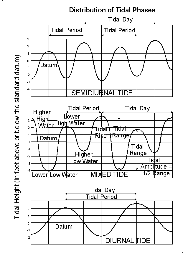
A tidal cycle is one high tide plus a successive low tide. Due to land masses, the movement of water moving around on the Earth's surface due to tides is impeded. The resulting tidal cycle or pattern, therefore, depends on geographic location. There are three basic types of tidal cycles that are globally distributed.
Semi-diurnal Tides
This is the most common tidal pattern, featuring two highs and two lows each day, with minimal variation in the height of successive high or low waters, and is very common along much of the east coast of North America.
Diurnal Tides
There is only a single high and a single low during each tidal day; successive high and low waters do not vary by a great deal. Such tides occur, for example, in the Gulf of Mexico, the Java Sea, and in the Tonkin Gulf.
Mixed Tides
These are characterized by wide variation in heights of successive high and low waters, and by longer tide cycles than those of the semidiurnal cycle. Such tides occur, for example, along the U.S. Pacific coast and many Pacific islands.

Plots showing the variation in tidal curves for diurnal, semidiurnal, and mixed semidiurnal tidal cycles during a tidal period and tidal day.
Semidiurnal Tide
Tidal period: Time between high tide peak (lower) to high tide peak (higher) or low tide trough (lower) to low tide trough (higher).
Tidal day: Time between higher high tide peak to higher high tide peak.
Mixed Tide
Tidal period: time going through the peak of lower high water, higher low water, and the peak higher high water.
Tidal day: From the peak of higher high water, to lower low water to lower high water to higher low water back to the peak of higher high water.
Diurnal tide
Tidal period = tidal day: between the peaks of high tide

Summary of Waves and Tides
Summary of Waves and TidesIn summary, waves and tides can have a profound influence on the morphology and evolution of a coast. In areas with large waves and thus high wave energy, sediments can be extensively reworked by the erosive energy of the waves and widely distributed by the process of longshore transport. In high-energy coastal areas with strong tidal currents, large volumes of sediment can be transported or reworked by the tidal currents to create deposits that are aligned perpendicular to the coastline but parallel to the flow direction of rising and falling tides. In coastal areas that have large tidal ranges or are low gradient, some parts of the shoreline may be exposed for several hours each day before the next rise in tide, and extensive mudflats can develop for very large horizontal distances.
For more information on tides and waves:
- Why does the ocean have waves?
- Wikipedia website with a discussion of tidal range
- Wikipedia website with a discussion of longshore transport
Video: Longshore Transport (2:19) (Video is not narrated.)
Wave, Mixed Energy, and Tide Dominated Hydrographic Regimes
Wave, Mixed Energy, and Tide Dominated Hydrographic RegimesOur understanding of waves and tides now sets the stage for a more thorough understanding of how they interact to shape a coastal zone. In the context of the hydrographic regime, there are two fundamental things that must be considered: the wave and tidal energy of a coast.
- Wave energy (E) is a function of wave height (H) with the energy (E) of a wave approximately equal to the square of the wave height (H2).
- Tidal energy can be equated with tidal range because it is the rise and fall of the tides that produce tidal currents. Tidal range (TR) is the vertical difference between high and low tides, which are commonly categorized into three ranges:
Microtidal: TR < 2.0 m
Mesotidal: 2.0 m < TR < 4.0 m
Macrotidal: TR > 4.0 m
The relative dominance of wave versus tidal energy dictates coastal morphology, and three general regimes exist along depositional coasts:
- Wave Dominated Coasts
- Mixed Energy Coasts
- Tide-dominated Coasts
Wave Dominated Coasts
Along wave-dominated coasts, the role of the waves and, thus, longshore transport processes is the dominant factor controlling the coastal morphology. Because longshore transport carries sediment along the shore, these types of coasts tend to have long linear barrier islands and beaches with relatively few inlets or passes between the open ocean and the more interior bays and waterways. The reason for this is that the longshore transported sediment tends to fill in these inlets and passes. Since the tidal currents are relatively weak, there is no energy available to keep the inlets open as a connection between the open ocean and interior waterways.

Mixed Energy Coasts
Mixed energy coasts are a product of both wave and tidal processes and neither process exerts an excessive influence on the coastal morphology, although some mixed energy coasts show tidal or wave dominance. Rarely in nature are processes in equilibrium. These types of coasts typically contain short stubby barrier islands, have numerous tidal inlets and passes, and are separated from a mainland by extensive marshes and an array of tidal creeks.


Tide Dominated Coasts
Tide dominated coasts are those where strong tidal currents act to redistribute sediment along the vector of falling and rising tidal currents, which are orientated perpendicular to the trend of the coastline. Quite often, the highest energy tidal currents develop in locations where large tidal ranges are present in conjunction with a shoreline morphology that accentuates tidal flow by constricting tidal currents into funnel-shaped embayments. Sediment is reworked by the resulting tidal currents to create subaerial and subaqueous tidal shoals and islands that are aligned parallel to the tidal flow direction, perpendicular to the coastline. Moreover, in areas with very large tidal ranges, extensive tidal flats, and marsh or mangrove systems form along the borders of the embayment and can cover large areas.


Learning Check Point
Learning Check PointPlease take a few minutes to think about what you just learned, then answer the question below.
There is no credit for this activity, but this point, you should know that the relative energy of tides and waves along a coast strongly affects how sediment is transported and the morphology of the coast. You should be able to explain how you think different coastal zones look in the context of the relative strength of tides or waves.