Module 9: Managed Retreat
Module 9: Managed RetreatIntroduction
In Module 9, we will explore questions around whether rebuilding after a major hurricane or repeated coastal flooding is the best approach. Here, we will look at some of the alternatives to rebuilding in place and strengthening the flood defenses with larger and stronger structures. We will consider the concepts of managed retreat, moving entire communities, and alternate approaches for achieving more resilient coastal communities.
Goals and Objectives
Goals and ObjectivesStudents will be introduced to ideas of managed retreat and relocation of communities in coastal environments due to repeated impacts from coastal hazards; they will consider the idea of multi-layered defenses and continue to examine the rebuild versus retreat debate.
Learning Objectives
By the end of this module, students should be able to:
- investigate alternative methods for non-structural shoreline hazard mitigation, including managed retreat and multi-layered defenses;
- explore the pros and cons, including cost-benefits of managed retreat case studies and consider examples of communities facing retreat as an option and the factors leading to these decisions;
- analyze hypothetical storm surge impacts on communities on the Louisiana coast using Google Earth and online tools.
Module 9 Roadmap
| Activity Type | Assignment |
|---|---|
| To Read | In addition to reading all of the required materials here on the course website, before you begin working through this module, please read the following required readings to make sure you are familiar with the content so you can complete the assignments.
Extra readings are clearly noted throughout the module and can be pursued as your time and interest allow. |
| To Do |
|
Questions?
If you have any questions, please use the Canvas email tool to contact the instructor.
Alternate Approaches to Coastal Hazard Mitigation
Alternate Approaches to Coastal Hazard MitigationAfter Super Storm Sandy devastated the New Jersey coast and flooded coastal New York, including parts of Manhattan, the debate about rebuilding in place or implementing more sustainable coastal hazard mitigation practices has raged in the U.S.
The traditional practices in the U.S. and in other countries around the world have been to armor the shorelines and replenish beaches to prevent or mitigate erosion. Here in the U.S., recovery from flooding has relied on programs such as the National Flood Insurance Program, the Federal Emergency Management Agency (FEMA), and others, to allow home and business owners to rebuild.
Around the world, there is a growing recognition that hard structure protection and rebuilding in place are not sustainable practices, especially as we become increasingly aware that storms of Sandy and Katrina magnitude may be occurring more frequently with our changing climate. Greater emphasis is now being placed on coastal communities developing better resilience to repeated coastal flood events and sea level rise.
Following the devastation of Sandy in the northeast, some geologists weighed in on the debate to advocate alternatives to rebuilding, such as managed retreat. Here, we will take a look at some ideas from one leading group of coastal scientists, led by Orrin Pilkey, who has spent his career thinking and writing about how to live with dynamic shorelines. Here, he is vocal in making the call that there needs to be a change in policy in the U.S. when it comes to trying to combat catastrophic flooding along our coasts. The case study focusing on rebuilding after Sandy on the Jersey Shore in the reading "Rebuild or Retreat from the Jersey Shore", in which a piece from WNYC follows homeowners debating on the future of their community after Sandy, highlights once more the dichotomy of opinions about the need to retreat from the shoreline versus the need to maintain a lucrative tourism and vacation home economy by holding things in place, at least for now.
Required Readings
Read the following two articles in which Orrin H. Pilkey, emeritus professor of earth sciences at Duke University, explains the rationale behind moving away from the “madness” of rebuilding in places that have proven to have high rates of repetitive impacts of coastal hazards such as hurricane storm surges. In the second piece, other opinions are voiced in relation to the dilemma on the Jersey Shore. As you consider the range of opinions, make a list of key points, and use these to answer the Learning Check Point questions below to reflect on the ideas put forth and develop your own ideas about the need to change the way things are done on built shorelines in the U.S.
After reading both articles, please complete the Learning Check Point below before moving onto the next section.
Learning Check Point
While this Learning Check Point is not for credit, you will be expected to know the material for the Module 9 Quiz.
Please take a few minutes and answer the questions below.
What is Managed Retreat?
What is Managed Retreat?In the readings on the previous page, much of the thinking was in response to a catastrophic event, such as Hurricane Sandy. On the Jersey Shore, the emphasis has been on building higher dunes to mitigate the problem of coastal hazards threatening human infrastructure. However, as the coastal scientists point out, dunes and other beach features have a tendency to migrate landward. As sea levels rise, this natural migration will accelerate. Options that involve working with these natural processes rather than trying to control them involve a longer-term approach and, as we have seen, can be controversial. We will look at some examples of places where these alternative methods have been employed using the principles of managed retreat or managed realignment, which are in contrast to the more reactionary approach of rebuilding structures in place and protecting them with dunes and other engineered lines of defense.
Managed retreat or managed realignment is a coastal management strategy that allows the shoreline to move inland, instead of attempting to hold the line with structural engineering. At the same time, natural coastal habitat is enhanced seaward of a new line of defense. This approach is relatively new, but is gaining traction among coastal policymakers and managers in the face of increased coastal hazard risks. There is a growing recognition that attempting to “hold the line” in many places is a losing battle.
In many cases of managed retreat, human development is “moved” out of harm’s way and natural areas are restored to enhance their ecosystem services. Typically, flood defenses are set back from the shoreline, and flooding is allowed in the previously defended area. Usually, natural coastal habitat is preserved seaward of the man-made defense, and it provides extra protection or a buffer from flooding.
Managed retreat can be complex and often contentious, as it can include delineating a new line to which structures can be built and home and business owners must be bought out.
Components of managed retreat may include:
- coastal planning;
- relocation and buy-back and buy-out programs;
- regulating types of development allowed;
- designating no-build areas;
- habitat restoration;
- replacement of built environment with green space.
For managed retreat or managed realignment to be successful, a number of criteria or conditions must be met, according to authors Gardiner et al., and Rupp and Nicholls. These are listed below. Perhaps points 4-6 are the criteria that are lacking most often. As we will read in the following case studies, few managed retreat projects are accomplished without controversy and lengthy debate. In places where the level of development on the shoreline is high, managed realignment may not be an option at all, at least in the present conditions.
"Six of the most important conditions are given below (Gardiner et al., 2007; Rupp-Armstrong and Nicholls, forthcoming):
- presence of coastal defenses
- availability of low-lying land
- desire or need to improve flood or coastal defense systems
- presence of a sustainability-oriented coastal management attitude
- desire or need to create intertidal habitats
- societal awareness about the benefits of managed realignment"
In this module, we will explore examples of managed retreat in the U.S. and the U.K. to gain an understanding of the complexities of implementing these projects. We will also consider the discussions of managed retreat options in large cities that are particularly vulnerable to inundation.
In addition, we will look at the dilemma of whole communities facing decisions to relocate in the face of repeated flooding, as well as other mitigation measures such as elevating homes and changing building codes.
Learning Check Point
Objective
Investigate alternative methods for non-structural shoreline hazard mitigation, including managed retreat and multi-layered defenses.
While this Learning Check Point is not for credit, you will be expected to know the material in Module 9 Quiz.
Explore the examples of managed retreat in this ArcGIS Story Map, created by Virginia Institute for Marine Sciences: After reading, consider how you would answer the questions on the cards below. Click "Turn" to see the correct answer on the reverse side of each card.
Examples of Managed Retreat in the U.S.
Examples of Managed Retreat in the U.S.California Coast
On this page, you will visit two locations on the California coast where the process of managed retreat has been used to address shoreline erosion problems. In the first example, at Ventura Beach near Santa Barbara in southern California, stakeholders worked together to find a solution to a chronic shoreline erosion problem. In the second example, at Pacifica Beach near San Francisco, wetland and riparian habitat were enhanced while at the same time moving structures out of the way of flooding and erosion. As you will see, both examples are in locations that have a medium level of human development, a motivated group of residents, and diverse stakeholders who collaborated to produce and execute a long-term plan. Both areas are in economically healthy areas, which makes raising funds more feasible. However, none of these things are easy to accomplish. These small-scale, less than ten-acre projects serve as valuable learning experiences, but larger-scale projects of similar kinds will likely need to be implemented in the near future, on the scale of, for example, Ocean Beach, which you studied in Module 8 Lab.
In the Ventura Beach example (Climate.gov - Restoring Surfer's Point), Surfers' Point Shoreline Managed Retreat Project is described and illustrated. The article outlines the challenges that had to be overcome to find consensus among the many stakeholders, with the project taking a decade to come to fruition. The stakeholders found that "Focusing on goals they had in common and identifying a bounded problem helped the groups converge on a single solution strategy. The decision to retreat from the ocean—pulling existing structures inland to make room for natural beach processes—allayed concerns that a hardened solution such as a seawall would degrade conditions for surfing, opened opportunities to rehabilitate the beach ecosystem, and enhanced the natural protection of assets on land." In this example, the road and parking areas are moved back and the beach and dunes widened. Volunteers planted native vegetation on the dunes, which serve as natural habitat and protection for the human structures behind the beach.
Restoration and Managed Retreat of Pacifica State Beach examines the Pacifica Beach effort to create climate change coastal community resilience. At Pacifica Beach, the managed realignment project is touted as a success.
Examples of Managed Retreat in the U.K.
Examples of Managed Retreat in the U.K.The U.K., being a relatively small island nation with a dense population, has a somewhat different approach to coastal management than the U.S. As a result, managed retreat, or managed realignment as it is called in the U.K., has been under serious consideration for a longer period of time than in the U.S. In the winter of 2013 -2014, tremendous storms caused extensive coastal flooding, bringing coastal management to the forefront.
Required Readings
- There are several examples of managed realignment in the U.K., Three are outlined in this article: Managed coastal realignment projects in the UK: ‘working with nature. Read the article, and begin a list of pros and cons of managed retreat vs. “hold the line” strategies involving hard structures such as higher sea walls and rock barriers.
Ecosystem Services of Coastal Marshes
Research shows that natural coastal marsh habitats provide many ecosystem services, including attenuation of storm surge. Attempts to quantify the amount of protection provided by coastal marsh has been elusive, but researchers conclude that “It is clear that coastal management decisions should consider the dynamics of natural coastal systems previous to human modification and be cautious about any actions that erode the natural benefits and ecosystem services provided by salt marshes.” (Shepard et al., 2011). This statement is based on the fact that research strongly indicates that coastal marshes play a very important role in protecting human infrastructure from coastal hazards, including sea level rise and storm surges. (Reference: Shepard CC, Crain CM, Beck MW (2011) The Protective Role of Coastal Marshes: A Systematic Review and Meta-analysis.)

Managed Retreat as a Response to Disaster
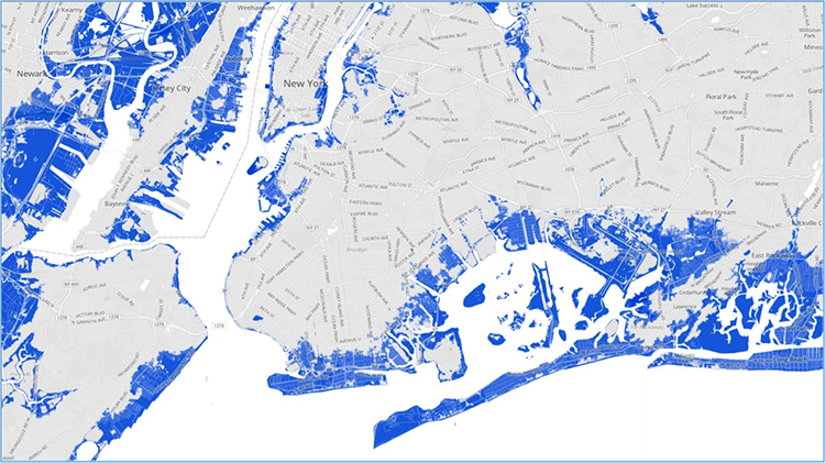
Managed Retreat as a Response to DisasterHurricane Sandy came ashore on the New York/ New Jersey shoreline on October 29, 2012. This late-season storm was dubbed “Superstorm Sandy” because of its massive size and because it coincided with a spring high tide (full moon), which exacerbated the height of the storm surge. The massive storm surge inundated a large swath of the coastline, which includes New York City. Parts of the New York Subway system were flooded, widespread power outages crippled the city, and low-lying neighborhoods were destroyed across the region. The statistics for New York alone sum up the storm’s magnitude:
- 43 deaths - 23 of whom perished on Staten Island.
- $19 billion in damages
- 90,000 buildings in the inundation zone
- Nearly 2 million people without power
The size of the area inundated is illustrated by the FEMA flood map image below.
Sandy’s massive impact on such a densely populated and economically important region of the United States precipitated an unprecedented response by area leaders. Both New York Governor Cuomo and former New York City Mayor Bloomberg have taken strides to encourage residents to consider the future of New York’s coast in light of sea level rise predictions.
Former Mayor Bloomberg and the New York City Government were proactive in the development of the NYC: Special Initiative for Rebuilding and Resilience which produced a comprehensive report calling for a “stronger, more resilient New York”. Recommendations found in the report include a multi-faceted approach, including flood protection systems (levees, floodwalls, floodgates, etc.), as well as the designation of certain areas to be set aside as green space. It takes into account the fact that 25% of the city is flood-prone and that sea level rise will only make matters worse.
New York Governor Cuomo, meanwhile, initiated a buyout program for homeowners whose homes were in areas likely to experience repeated flooding. This buyout program has been successful, particularly in Staten Island and in other New York neighborhoods especially hard hit by Sandy. Areas are being returned to green space rather than being rebuilt. Case studies are featured in this module.
A slightly different approach to managed retreat is sometimes necessary in the face of a natural disaster. So, rather than using the types of managed retreat projects described in the previous section, that are carefully planned and take place in discrete locations, moving homes and businesses to safer locations urgently comes to the forefront as we saw in Unit 2. In these cases, decisions are often made quickly and are driven by economic necessity.
Retreat as a Response to Disaster: New York Example
Retreat as a Response to Disaster: New York ExampleHurricane Sandy Recovery: Staten Island’s Fox Beach Community.
Following a natural disaster caused by a storm such as Sandy, a different approach to retreat is often considered. In this case, rather than using the managed retreat projects described previously in this module, which are carefully planned and take place in discrete locations with a long-term vision, the action of moving homes and businesses to safer locations urgently comes to the forefront. In these cases, decisions are often made quickly and are driven by economic necessity and the availability of funds resulting from the disaster itself.
Required Reading
The following two articles from the Module 9 Roadmap look at the case of the New York Smart Home Buyout Program in the Fox Beach community of Staten Island, initiated by Governor Cuomo in 2013 (see press release excerpt further below). The program provided funds to purchase homes in particularly flood-prone areas severely impacted by Sandy’s storm surge. In addition, the program was designed to discourage rebuilding after Hurricane Sandy, by providing a monetary incentive to move to higher ground, and was met with a measure of success in certain areas.
Learning Check Point
Government Buy-Out of At-Risk Coastal Properties – New York Example following Sandy
Objective: Investigate alternative methods for non-structural shoreline hazard mitigation, including managed retreat and multi-layered defenses.
Although this Learning Check Point is not for credit, you will be expected to know the material in the Module 9 Quiz. Once you read and understand the articles referenced above as well as the excerpt below, take a few minutes to answer the questions about the New York Home Buyout Program in the space provided.
Government Buy-Out of At-Risk Coastal Properties – New York Example following Sandy
Excerpted from a March 2013 press release from New York Governor Andrew Cuomo’s Office:
Recreate NY Smart Home Buyout Program - $171 million: Certain areas are at high risk for repeated flooding, causing damage to homes and risking the lives of residents and emergency responders. To reduce those risks and provide residents with an opportunity to leave their properties, New York State will offer voluntary Buyouts for homes that were:
- substantially damaged inside the 500-year flood plain, or
- located within designated buyout areas where damage has occurred and where property may be susceptible to future damage due to sea level rise and other factors. These enhanced buyout areas will be selected in consultation with county and local government officials.
- In very high-risk areas, there will be a prohibition on rebuilding and these areas will be used as buffer zones. Under the state's proposal, and subject to approval by HUD, re-development of property outside of the 100-year floodplain that is acquired through a buyout would be permitted, so long as the new structure is built to mitigate future flood impact. Homeowners will be notified if they are eligible for a buyout after HUD has approved this plan.
Definition for "500-year flood plain" and "100-year flood plain"
A "100-year flood" is not a flood that will occur once every 100 years. Instead, it should be thought of as flood elevation that has a 1-percent chance of being equaled or exceeded each year. Therefore, a 100-year flood could occur more than once in a relatively short period of time. A 500-year flood elevation has a 0.2% chance of being equaled or exceeded in any given year.
If the trend of more frequent storms and increased sea level rise continues, these types of solutions will likely become more common. Who will foot the bill to move coastal communities? Will it happen only after disasters, or in a more planned way? In the case of Isle de Jean Charles, government funding was found in the form of a grant awarded to relocate the entire community. However, many challenges have plagued even this small-scale relocation project. We saw that long-term planning was lacking in Ocean Beach, CA. What will the approaches to these dilemmas be in 10 or 15 years from today? These are questions for us to ponder at this point. Policymakers, planners, community leaders, and politicians will have to quickly find solutions to these challenges for many communities soon.
Relocating Coastal Communities: Isle de Jean Charles
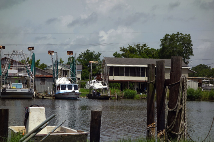
Relocating Coastal Communities: Isle de Jean CharlesCoastal Louisiana is home to hundreds of small communities, as well as several larger towns (such as Lafitte, Houma, and Thibodaux), that are not protected by the large federally subsidized hurricane protection levees such as those that surround New Orleans. The new hurricane protection system for the area, that is currently under construction, cannot incorporate all of these communities, although the Morganza to the Gulf levee* when it is completed, will include the larger towns listed here. One community that will not be included is the small town of Isle de Jean Charles in Terrebonne Parish. This small, mostly Native American community is grappling with relocating and creating a new community after receiving federal funds for resettlement.
Video: Isle de Jean Charles from the documentary LAST STAND ON THE ISLAND (11:23)
As the short film below will demonstrate, not all the residents agree with Chief Naquin’s decision.
Isle de Jean Charles from the documentary Last Stand on the Island
Visitor to island: You and I will enjoy this marsh. Our kids will enjoy some of it. Our grandkids don't stand a chance.
Island Resident's voice: The island was very big. We had a lot of trees on both sides of the island. But now, we ain't got no more trees, just a few. So, the saltwater messed up everything.
The oil company has digged some canals. The more canal you dig, the more water passes through. And then, after they dug the canals, saltwater start to come in. And then, that is when the erosion started. So, the saltwater messed up everything.
Visitor to island: And every time you're out there fishing, you see a nice clump of grass floating on down with the current. That's piece of marsh going.
Island Resident 1: I am what I am. Nobody gonna move me. And if you try enough to move me, you got a problem. First, that's my home, my land, and I like it down here. So, that's how we live and that's how we gonna stay.
Visitor: Don't stand a chance unless they get to know ya. It's almost like a gated community, but there's no gates.
Island Resident 2: Hurricanes start to come, left and right. Andrew in '92. We had a lot of water. For Andrew, we had about 3 foot of water in the house. My house was done. And then, the next one came in 2002: Lili. Then, we had some water. That's when we started raising up the house. Because they had five foot of water on the land, over here. And then, after that, every two years, two, three years, we had a hurricane.
Island Resident 1: We didn't really get that much water for them hurricanes, but there was hurricanes with plenty of water.
music
Island Resident 2: Like the people on the island, they can do. They do almost everything for themselves, ya know? We used to build our own house. With two, three men together. Build a house ya know?
Visitor: I got to admit I can understand why these Indians down here, they're so in love with this, with this little island. This is just like heaven down here. This beats any camp that I have ever been to. You try to just protect this little bitty piece of marsh, ya know? We don't really tell anybody about this down here. We try to keep it a secret.
music
Island Resident 2: We don't care about Albert. Albert don't run the island. He's the chief, but he don't run us you know? We do what we please.
music
Chief Albert Naquin: My deal is to get a big enough piece of land and not have to worry about oil spills or hurricanes. Let's say we'll take this reservation here, and we'll take it and we'll move it here. And this is the reservation.
Interviewer: So, you wouldn't want the reservation to be on the island?
Chief: Well, would you?
music
Chief: Consider the deal we got right now, with the Morganza-to-the- to the Gulf, and leaves us out in the open? We'll just wash away.
Resident 2: Maybe they want to take the island. Give that to the rich people, the millionaire.
Resident 1: We're not gonna sell the island. Ain't nobody can buy that island, partner. Before they buy that island, there gonna be a war. You see, when they was talking about moving the people off the island, I bought 200 dollars worth of ammunition - me. And I got four guns. Only thing I don't got is a machine gun. But I'm fixing to put my hands on one.
music
Resident 1: We know how to shoot guns. We got bows and arrows, we got hatchets. We can throw hatchets. I can throw a hatchet to that tree and stick it in that tree.
music
Resident 1: See, the people think we're stupid on the island. But we're not.
Isle de Jean Charles Resettlement Story
The Isle de Jean Charles residents have long been aware that the island's days are numbered as sea level rises and erosion of the marshes continues. Their houses are flooded and damaged regularly. Even so, many residents are resistant to the idea of leaving the island because of their strong attachment to the land and the way of life, including living off the water by fishing, shrimping, and crabbing. In 2016, the community of Isle de Jean Charles was the recipient of a $48 million grant from the Department of Urban Development - HUD to relocate the families of the "Island" to a safer location, 40 miles inland near the community of Schriever. This is the first time a community has received federal funding and support for a relocation of this kind. The resettlement plan, which is still in progress, has not progressed smoothly. The original intention of tribal Chief Albert Naquin was to keep the tribal community intact and create a new community that allowed displaced members who had previously left the island to rejoin the community. There are many details and concerns to be worked out between the tribe and the state. To date, 23 families have committed to relocating to the new community. Others are staying behind. The actual move is still several years ahead. The difficulties encountered highlight how challenging relocating a community can be, especially if the community wishes to stay intact. The dilemmas and challenges met by Isle de Jean Charles are likely to play out in many places as sea level rise claims other coastal communities.
Recommended Reading
- Read about the Morganza to the Gulf Levee in this U.S. Army Corps of Engineers: Morganza to the Gulf fact sheet.
For a more in-depth look at the story of the resettlement of IDJC residents, please read the following two articles:
Learning Check Point
The resettlement website has details of this plan and a video in which Chief Naquin and others outline the plan. Read the articles and watch the video on Isle de Jean Charles to help you understand the dilemma faced by such a small, tight-knit community. Consider how you would answer the questions on the cards below. Click "Turn" to see the correct answer on the reverse side of each card.
Multi-Layered Defenses
Multi-Layered DefensesLouisiana is an example of a very low-profile coastal area characterized by relatively newly deposited delta sediment (less than 10 thousand years) of the Mississippi River delta. Land loss has been ongoing at a rapid pace over the past century, peaking in the late 20th century, and is currently occurring at a rate of approximately 10 – 20 square miles per year. The communities in coastal Louisiana are all at risk of storm surge inundation, to varying degrees. We have already looked at New Orleans in detail and seen that it has a system of flood defenses recently upgraded after Hurricane Katrina. Many smaller communities that are located close to the Gulf of Mexico have no protection from federally funded flood protection. Many have levees built and maintained at a parish level. New federally-funded hurricane protection levees, such as the Morganza to the Gulf levee system are planned to protect towns such as Houma and Thibodaux. It is approximately 100-mile-long levee that averages 6 meters (20 ft) in height. But some small communities such as Cocodrie and Isle De Jean Charles will not be within the footprint of this levee. It is not feasible in terms of available funding and engineering options to protect some communities. This presents a dilemma for many communities.
Louisiana's Coastal Master Plan and Multi-layered Protection
Levees are not the only form of protection for coastal communities. Louisiana’s Coastal Master Plan incorporates the concept of a multi-layered defense system that includes maximizing the flood mitigation potential of barrier islands, marsh, and natural ridge restoration projects, (many of which involve pumping sediment from a designated location, often from the bottom of the Gulf of Mexico), as well as the use of fresh water and sediment diversions from the Mississippi River to build new land.
Recommended Reading
Learn more about this complex plan by visiting Louisiana’s 2023 Coastal Master Plan. At this site, you can read an overview of the plan, its objectives, its progress to date, and the principles upon which it is founded.
What is Multi-layered Protection?
A clear explanation of the concept of Multi-layered protection is presented by the Lake Pontchartrain Basin Foundation outlined at Multiple Lines of Defense Strategy. This conceptual approach identifies eleven “lines of defense”, which work in concert to ameliorate the effects of a storm surge by creating friction and reducing storm surge and wave height as it moves inland across the low-lying delta land. This plan was published and incorporated into Louisiana's Coastal Master Plan in the years after Hurricane Katrina. The eleven layers of protection are shown in the diagram below:
- Offshore shelf
- Barrier islands
- Sound
- Marsh land bridge
- Natural ridge
- Highway
- Flood gate
- Levee
- Pump station
- Elevated buildings
- Evacuation route

Video: FPA East Virtual Tour (16:06)
This is a virtual tour of the 17th St Canal Pump Station and the Surge Barrier in New Orleans. The first part focuses on Hurricane Katrina's destruction, while the second part showcases the flood protection system: Hurricane Storm Damage and Risk Reduction System (HSDRRS).
FPA East Virtual Tour
[DIAL TONE]
PRESENTER 1: Devastating damage expected. Hurricane Katrina, a most powerful hurricane with unprecedented strength rivaling the intensity of Hurricane Camille in 1969. Most of the area will be uninhabitable for weeks, perhaps longer. At least 1/2 of well-constructed homes will have roof and wall failure. All [INAUDIBLE] leaving those homes severely damaged or destroyed. The majority of industrial buildings will become nonfunctional.
Partial to complete wall and roof failure is expected. All wood-frame low-rising apartment buildings will be destroyed. Concrete block low-rise apartments will sustain major damage, including some wall and roof failure.
High-rise office and apartment buildings will sway dangerously, a few to the point of total collapse. All windows will blow out. Airborne debris will be widespread and may include items such as household appliances and even light vehicles.
Sport utility vehicles and light trucks will be moved. The blown debris will create additional destruction. Persons, pets, and livestock exposed to the winds will face certain death if struck. Power outages will last for weeks as most power down and transformers destroyed.
Water shortages will make human suffering incredible by modern standards. The vast majority of native trees will be snapped or uprooted. Only the heartiest will remain standing but be totally de-foliated.
Few crops will remain. Livestock left exposed to the winds will be carried. A [INAUDIBLE] hurricane wind warning is issued when sustained winds near hurricane force [INAUDIBLE] hurricane force are certain within the next 12 to 24 hours. Once tropical storm and hurricane-force [INAUDIBLE], do not venture outside.
[ALARM SOUNDING]
PRESENTER 2: On August 29, 2005, Hurricane Katrina made landfall in Louisiana, forever reshaping the landscape and the lives of those in its path. In addition to a path of destruction, the storm left people of New Orleans with uncertainty. Could New Orleans rebuild? And if so, how would the Crescent City survive if another storm similar to Katrina's strength was to strike?
With that question in mind, the federal government and the US Army Corps of Engineers went to work planning, designing and building one of the most ambitious flood protection systems in the world. The result is what you see today. The levees, barriers, and pumps that make up the Hurricane Storm Damage Risk Reduction System, known as HSDRRS.
Today, this system is operated and maintained by the team at the Southeast Louisiana Flood Protection Authority East.
[MUSIC PLAYING]
Welcome to the pump station at the 17th Street Canal. In the aftermath of Hurricane Katrina, the US Army Corps of Engineers constructed interim closures with temporary pumps at the mouths of the 17th Street, Orleans Avenue, and London Avenue outfall canals. The goal here was to prevent storm surge from Lake Pontchartrain from entering the canals during a tropical event, thereby reducing the risk of a failure along the canals.
The Corps' intent was to follow this temporary measure with the construction of a permanent, highly-automated, more sustainable solution. Soon we'll take an in-depth look at the more permanent solution. Let's begin our tour.
To your right, you will see the hydraulic gates that, when closed, cut off the lake from the canal. These gates are a critical part of the system. The brick building in front of you houses the pumps. We will head in there shortly. But first, let's head around to the back of the building.
You might be wondering what is significant about this side of the building. Well, for starters that is the 17th Street Canal in front of you. During a tropical event, any time the city pumps drainage water into the canal, we, in turn, pump the canal water into the lake. The goal is to prevent levee failure by reducing the stress on the canal walls.
The other thing you will notice is the metal structures coming up from the canal and towering over you. That is part of the mechanical screen and, when turned on, it will filter out debris from the water entering the pump station. Large screens catch the debris and then travel up the large metal tracks you see before you.
As they round the top, the debris falls onto the concrete pad that you're standing on. All right, it's hot out here. Let's head inside and get out of the sun. The building that we are now in houses the pumps at the end of the 17th Street Canal.
The giant machines that surround you are the pumps that help keep New Orleans safe, thus ensuring when the sewage and water board pumps are running the flow of water is one-directional, moving from the canal into the lake. Our two smallest pumps, which are all the way down on your left, can move 900 cubic feet of water a second, while our more numerous larger pumps can move double that-- 1,800 cubic feet of water in a single second.
To fully grasp how large these pumps are, notice how small Maintenance Mike looks when standing next to one. Let's move closer so you can take a look around some more. In order to protect New Orleans from flooding during a Hurricane, the pumps themselves need to be protected. This building has been designed to withstand sustained winds of 155 miles per hour and gusts up to 200 miles per hour.
From up here, you can get a better understanding of just how large these pumps truly are. Hang here for a bit and spend some time taking in the sights and sounds. It's OK to feel a little overwhelmed. It's quite impressive.
Now let's head down to the basement. Welcome to the basement of the pump station. Feel free to look around. And we'll start the tour back up in a moment.
Down here, we are standing 25 feet below the canalside water level. If you know anything about New Orleans, you know that basements are, well, rare. Each of these pipes is over 9 feet in diameter.
You'll notice Maintenance Mike taking his time inspecting the nuts and bolts holding these intake pipes in place. Each nut is striped with a yellow line so that we can easily tell over the course of time if they have come loose. When the yellow stripe on the nut lines up with the stripe on the bolt, we know they are tight and safe.
Interestingly enough, the water is not just pumped through the facility. But it is actually pumped from the bottom of the canal, up these pipes, and out through the lake side of the building. While the water is discharged below the surface, it has enough force to create a noticeably large wave.
So what does it take to move this much water? A whole lot of power. Welcome to the generator bay. Here you will find 15 2.6 megawatt generators. Take a look around for a bit.
When it comes to protecting the city of New Orleans from flooding, redundancy is everything. Each pump has two of these generators dedicated to it. In addition to that, this facility has generators and an on-site fuel storage facility allowing for full operation and off-grid protection.
The first thing many people think of when it comes to flood protection are the giant pumps that we just saw. However, those pumps only remove water from the city. What prevents water from entering New Orleans? Hold on tight.
Welcome to the IHNC Lake Borgne Surge Barrier. Consisting of over 3,000 piles, including 1,271 concrete cylinder piles that measure 66 inches in diameter and are driven to a depth of 130 feet into the ground, this is one serious barrier. So how does this all work?
Woo, back on solid ground. Directly in front of you is the main sector gate. When closed, you can walk across the Gulf Intracoastal Waterway, which is a major artery of marine commerce from Florida to Texas. Millions of dollars of shipments travel through this waterway on a daily basis.
Later on, we will take a look at the gate closing process. But for now, let's continue our tour. Further along is the Bayou Bienvenu Vertical Lift Gate and Bridge that help connect this nearly two-mile-long structure.
In fact, authorized vehicles are able to drive across for inspection and maintenance. Although it can be hard to see from here, the barge gate is exactly what it sounds like. It's a large barge that can be swung on in front of the barrier opening and then sunk to seal the opening off.
To your right and somewhat behind you is the primary control room. This is where the gate can be monitored and where the controls to open and close the gate are located. Take a minute to look around.
All right, ready to move on? Let's explore. Out here you can get a better view of the gate as well as see beyond the gate. Additionally, you will notice the building across the way. If you think this looks similar to the control room you saw earlier, you'd be right. That building is actually a secondary control room, allowing for the gate to be managed from both sides of the waterway.
Before we dive deeper into the gates, let's take a look at the surge barrier itself. As you look around, you'll notice on your right the levee portion of the flood protection system. While the pumps remove water from the city and the barrier closes off the flow of water, the levee helps protect against the storm surge typically associated with a major weather event. Let's move in a little closer to the levee.
Maintenance Mike is going to help us out now with a little demonstration. If you look slightly to your left, you'll see Mike standing next to the old levees which were part of the original flood protection system. These levees originally protected New Orleans against storm surges measuring up to 16 feet in elevation.
When standing next to the top of one, Mike is able to clearly see over it. These levees did the best they could. But to give you an idea of how challenging it was to prevent, the storm surge created by Hurricane Katrina was over 9 feet higher than these levees, topping out around an unprecedented 25 feet high. Now, Mike has moved across to the levees that are part of the new flood protection system.
As you can see, these are significantly higher than the old ones. In fact, at the highest point, the new levees are double the height of the old ones, topping out at 32 feet tall. Ready to move on?
Let's head back up to the gate and see if they are ready to start the closing process. Here we are in the control room, where our crew is about to get things started. Let's say a quick thanks to Patrick Brown for operating the gate for us today.
Now, let's head back outside to check out the action. Wow. Look at those gates close.
If you think they aren't moving, that's certainly understandable, as they do take over 15 minutes to move into place. But don't worry. You won't have to stand here in the heat for 15 minutes. Let's speed things up a bit.
Much better. All right, we're coming to the end of our tour. Before we leave, take a moment or two and look around some more.
We're back at the pump station and out of the sun. Thank you for joining us on the tour today. If you have any questions about something you saw, please do not hesitate to reach out to the New Orleans Flood Protection Authority East. Have a good one.
[MUSIC PLAYING]
Learning Check Point
Please take a few moments to think about what you just learned then answer the following questions to test your knowledge.
Module 9 Lab
Module 9 LabIntroduction
The objective of this Lab is to explore a low profile coastal area in Louisiana and use tools in Google Earth to measure the slope and evaluate the protective potential of the coastal wetlands and man-made levees separating the coastal communities from the Gulf of Mexico
For this Lab, you will be using Google Earth to explore the coastal area of Isle de Jean Charles and use data from a storm surge model to analyze the potential impacts of storm surges on this and nearby communities. You will consider the protective functions of the coastal marshes as well as the new hurricane levee that is designed to protect some communities but not Isle de Jean Charles.
Required Reading
Be sure you have read the U.S. Army Corps of Engineers: Morganza to the Gulf - Fact Sheet located on the Module 9 Roadmap.
Lab Overview
After you thoroughly read the U.S. Army Corps of Engineers fact sheet about the Morganza to the Gulf levee project (mentioned above), follow the steps in the Module 9 Lab Worksheet below.
Downloads/Resources
 Statement of Use of AI on Exams, Quizzes, and Labs
Instructions
Before you begin the Lab, you will need to download the Lab worksheet. We advise you to either print or download/save the Lab worksheet, as it contains the steps you need to take to complete the Lab in Google Earth. In addition, it contains prompts for questions that you should take note of (by writing down or typing in) as you work through the Lab.
Once you have worked through all of the steps, you will go to the Module 9 Lab. to complete the Lab by answering multiple-choice questions. The answers to questions on this Lab worksheet will match choices in the multiple-choice questions. Submit the quiz for credit.
Summary and Final Tasks
Summary and Final TasksIn Module 9, you investigated alternatives for coastal hazard mitigation, including managed retreat and multi-layered protection. You considered the pros and cons of managed retreat versus traditional solutions such as structural protection. You used online tools to make measurements of bed slope on the Louisiana coast in order to estimate storm surge impacts on a real community. You took into consideration the physical, social, and economic challenges that face coastal managers today to make recommendations for the future for a coastal community in Louisiana.
Reminder - Complete all of the Module 9 tasks!
You have reached the end of Module 9! Double-check the Module 9 Roadmap to make sure you have completed all of the activities listed there before you begin Module 10.
References and Recommended Reading
- Barbier, EB. Georgiou, IY, Enchelmeyer, B., Reed, DJ, (2013). The Value of Wetlands in Protecting Southeast Louisiana from Hurricane Storm Surges.
- Coastal Planning and Restoration Authority of Louisiana (CPRA) Louisiana’s 2012 Coastal Master Plan
- Deltares
- Shepard CC, Crain CM, Beck MW (2011) The Protective Role of Coastal Marshes: A Systematic Review and Meta-analysis.
- University of Minnesota Institute on the Environment (Ensia)