Building with Nature
Building with NatureMitigating Risks While Preserving Natural Processes
The simple concept of sediment supply along the coast and the unified concept of the coastal cell can be applied to other systems. For example, similar to the way a groin disrupts sediment transport downdrift of the structure, resulting in downdrift erosion until sufficient bypassing takes place, land reclamation practices, and the construction of levees, seawalls, and other storm protection structures including gates have their effects. On the one hand, land reclamation in tidal systems can alter the tidal exchange of water between the interior basin and the coastal ocean, and may yield sedimentation issues within the basin and near the tidal inlets. On the other hand, erosion within the basin, such as wetland loss, may have the opposite effect, resulting in widespread erosion at the inlets and sediment export due to the increase in tidal exchange. Levees that enclose open or semi-enclosed basins disrupt water, sediment, and nutrient exchange and may adversely affect submerged and intertidal habitat, including fish and other aquatic organisms.
Climate change sea level rise will continue to erode coastlines throughout the world for decades to come, and during these transgressive times, we cannot afford to be working against nature. This means that we must first understand the underlying processes governing the transport in the system experiencing these erosional cycles, determine accretion cycles, if any, and establish the best approach. Hardening the shorelines by seawalls and levees often implies a permanent boundary. Recall that sea levels rise and fall over geologic time with coastal imprints that span over generations; therefore, if we do not deal with issues now, the next generation will have to. Best approaches, for the most part, imply that we turn to soft, process-driven nourishment of eroding coasts that utilize natural processes – as opposed to mechanical placement – for the distribution of materials. Often these soft methods are the least disruptive to nature, including local and proximal ecosystems.
But we cannot protect cities by nourishment methods alone. In many cases, the installation of levees and other flood control structures will be necessary, especially if cities are already established. The relocation of cities or portions of cities will have catastrophic economic influence. When floodgates are needed, modern designs that utilize natural processes will be favored. An example we saw in the video from the Netherlands is the installation of gates that remain open most times to allow for tidal exchange and facilitate small changes in tidal range to maintain ecosystem function, closing only when cities are threatened by storms. Coupled with layered defenses, a concept introduced in Module 9, smart building in many cases can afford the needed protection while helping to lower future energy demands and maintenance costs and achieving overall higher ecosystem services and functions.
The following five case studies will help you learn about how some communities have built with nature to mitigate risks while preserving their natural resources.
Case Study 1: The Thames Barrier
Case Study 1: The Thames BarrierThe Thames Barrier spans 520 meters across the River Thames near Woolwich, protecting 125 square kilometers of central London from flooding caused by tidal surges and storms from the North Sea. The barrier became operational in 1982 with 10 steel gates that can be raised into position across the River Thames. When raised, the main gates stand as high as a 5-story building, are as wide as the opening of Tower Bridge, and weigh about 3,300 tons. The barrier is closed under storm surge conditions to protect London from flooding from the sea, but may also be closed during periods of high flow, to reduce the risk of fluvial (river) flooding in some areas of west London including Richmond and Twickenham. The Environment Agency (the agency responsible for the barrier operation) receives information on a potential surge from a variety of sources including weather satellites, oil rigs, weather ships, and coastal stations. At the onset of a predicted surge, the Thames Barrier will close just after low tide, or about 4 hours before the peak of the incoming surge tide reaches the barrier, a process that takes about 1.5 hours for all 10 gates. The Barrier will remain closed until the water level downstream of the Thames Barrier has reduced to the same level as upstream. As of March 2014, the Environment Agency has closed the Thames Barrier 174 times since it became operational in 1982. Of these closures, 87 were to protect against tidal flooding, and 87 were to alleviate river flooding.
Video: How does the Thames barrier protect London from floodings (00:43)
How does the Thames barrier protect London from floodings
The Thames barrier was built in 1982 on the River Thames on the eastern side of the capital at Woollett. The barrier made up of ten steel gates has a span of 520 meters across the river. Each gate is 15 meters tall. In an open position, the gates lie flat, allowing the Thames to flow freely and ships to pass through the gates. When the closed position is activated, it takes 75 to 90 minutes for the gates to rotate upwards and create a steel wall that blocks the river in an under-spill position. It allows a controlled amount of water to pass under the gate and up the Thames.

Case Study 2: The New Hondsbossche Dunes – Netherlands
Case Study 2: The New Hondsbossche Dunes – NetherlandsThe New Hondsbossche Dunes project – one of many examples of the Dutch government’s approach to smart building that utilizes natural processes – initiates and sustains continued dune nourishment. The principle of 'building with nature' is fully exploited to strengthen the Dutch coastline using a plan that couples smart building with layered protection. Superior to fixed solutions or hardscape approaches, the project employs nature to create a place with varied topography, complete with existing dunes overgrown with native vegetation, young drifting dunes and dune valleys, and a beach of varying width, all designed to be consistent with the existing dunes and to minimize dune erosion. The dunes offer natural mitigation from storm surges, with the added benefit of supporting a diverse population of plant and animal species. The plan is considered to be a dynamic solution because shifting sands and vegetation interact with the beach environment and continue to evolve organically and further bolster recreational activities.

Recommended Reading
For more information and project details visit: The New Hondsbossche Dunes
Case Study 3: The Sand Engine – Netherlands
Case Study 3: The Sand Engine – NetherlandsSimilar to dune restoration or creation, beach nourishment is a common soft approach to offset erosion. Sand can be mechanically pumped to replenish a beach following a storm or as part of a beach or barrier island restoration project. Alternatively, the natural process of longshore drift transports sand along the coast, not only eroding beaches but also accreting sand and building beaches. In either the mechanical or natural case, the addition of sand to the nearshore zone or beach increases local sediment supply. Mechanical spreading of pumped sand along the coast is common but can have a large ecological footprint and can be very expensive because the sand must be dredged, then transported, and finally distributed along the shoreline – sometimes over considerable distances. To minimize ecological damage and reduce cost, the Dutch developed an innovative way to let nature distribute the sediment instead, making the processes originally responsible for erosion now work on helping to accrete the beaches, at least locally. The concept is not new, but this was the first time that a natural nourishment project of this magnitude was carried out.
Recommended Reading and Viewing
- Please read the following article: How The Netherlands Became The Biggest Exporter Of Resilience.
- Please watch The Sand Engine Churns to Bring Sand to the Beach (3:08)

Case Study 4: MOSE flood barrier in Venice, Italy
Case Study 4: MOSE flood barrier in Venice, ItalyAlthough the threat is different from that in the case of the Thames Barrier, like London, the gated flood defenses of the MOSE project in Italy are designed to protect Venice from high tides and surges from the Adriatic Sea, thereby reducing flood frequency. The project takes advantage of the three main tidal inlets connecting the Venice lagoon to the sea, where a series of hollow gates on hinges initially resting on the bed will rise and close the inlets during periods of high tides. The MOSE barrier uses a completely different method than the approach used in the Thames Barrier. The idea, however, is similar in that for much of the time, when there is no imminent threat of flooding, the gates are filled with water and resting on the seabed; when floodwaters threaten Venice, the gates are closed in response to incoming high water. The smart building elements in this approach are in the design, the operation, and the utilization of processes and water properties to minimize operating costs, energy, and maintenance. The gates simply close under the influence of gravity by slowly filling up with seawater, and once fully open, the added weight of the steel when added to the weight of water keeps them submerged. To close the gates, the opposite of gravity, buoyancy, is used. Pumped air forces water out of the gates, and since the air density is more than a thousand times less than seawater, the gates are lifted into the closed position, rising above the water surface. The lack of mechanical infrastructure and arms to perform these steps keeps operating cost low, although, as we learned in earlier modules, the upfront capital costs for such projects can be in the billions of dollars.
Recommended Video: Venice - Lagoon: The MOSE System for the Defence Against High Waters (6:28)
Venice - Lagoon: The MOSE System for the Defence Against High Waters
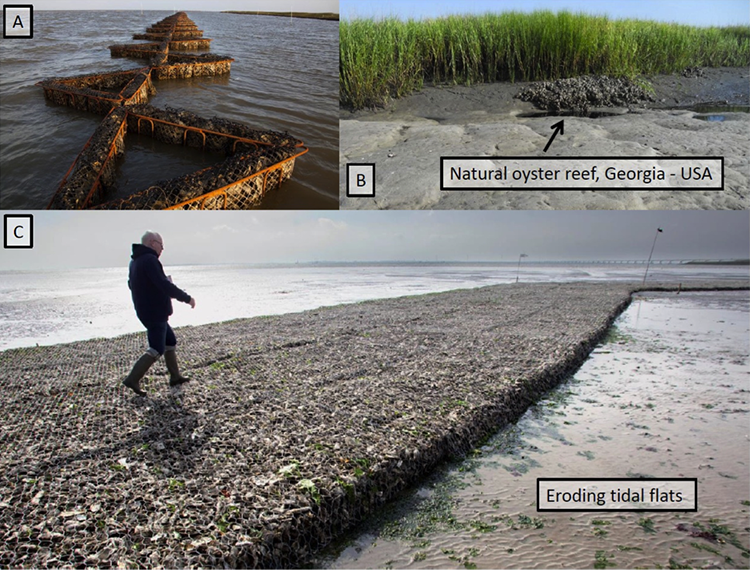
Case Study 5: Protecting Tidal Flats and Marsh Edges with Artificial Oyster Reefs
Case Study 5: Protecting Tidal Flats and Marsh Edges with Artificial Oyster Reefs“Ecosystem engineers” use ecosystems whose species’ activities are able to modify the local physical environment, for instance promoting sedimentation or assisting in the self-organization of landscapes. Ecosystem engineers have found that salt marshes, mangroves, and other habitats that can be effective agents for enhancing coastal protection.
In one of the most versatile ecosystems used by ecosystem engineers, oysters transform soft sediments into hard to form complex 3D structures (i.e., reefs) that modify the near-bed water flow and dissipate wave energy, thus influencing sediment transport dynamics and promoting sedimentation in nearby environments. Oyster reefs offer additional ecosystem services, such as water filtration, and their aggregations and biogenic structures facilitate dense assemblages of invertebrate species, as well as provide shelter and foraging grounds for juvenile fish and crustaceans. Oyster reefs are among the most diverse marine habitats.
In one instance of ecosystem engineering, oysters are used in clusters within arrangements of rebar to provide the basis of what will eventually become a reef and help reduce wave energy transmission onto the marsh edge and platform. This approach helps reduce the direct breaking wave energy arriving at the marsh edge and ultimately reduces shoreline erosion. Applications using such solutions include navigation channels and natural waterways where commercial and/or recreational traffic produces above-normal wave energy. The area between the reef and the marsh experiences increased sedimentation, which helps deliver more sediment onto the marsh platform; over time, this sediment accretes to a shallow slope that helps dissipate energy further, and potentially offsets erosion.
Another application uses gabions filled with oysters and oyster substrate to protect tidal flats. Tidal flats provide a variety of ecosystem services, but sea level rise and human-induced stresses are causing widespread erosion. To combat this erosion, experiments in the Eastern Scheldt estuary in the Netherlands (which you saw earlier in this module) use oysters to help reduce wave energy during sub-tidal conditions, trap sediment, and reduce erosion of the tidal flats. Reducing erosion sustains the landform, thereby extending the longevity of the flats and their habitat.
Learning Check Point
Learning Check PointTake a few minutes to think about what you just learned.
Objective: Understand the benefits of building with nature and distinguish smart building approaches.
Look at the image below.

